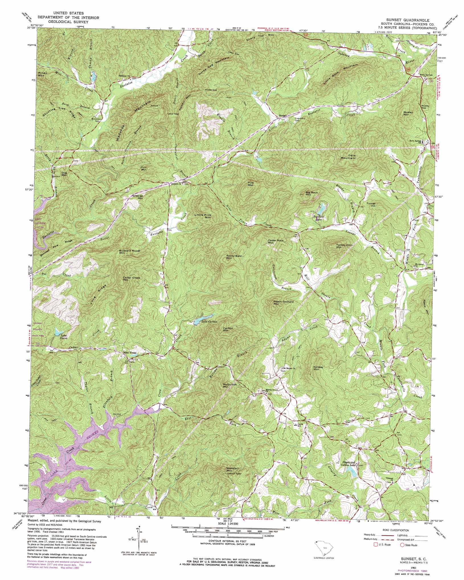
Sunset Topo Map South Carolina
To zoom in, hover over the map of Sunset
USGS Topo Quad 34082h7 - 1:24,000 scale
| Topo Map Name: | Sunset |
| USGS Topo Quad ID: | 34082h7 |
| Print Size: | ca. 21 1/4" wide x 27" high |
| Southeast Coordinates: | 34.875° N latitude / 82.75° W longitude |
| Map Center Coordinates: | 34.9375° N latitude / 82.8125° W longitude |
| U.S. State: | SC |
| Filename: | o34082h7.jpg |
| Download Map JPG Image: | Sunset topo map 1:24,000 scale |
| Map Type: | Topographic |
| Topo Series: | 7.5´ |
| Map Scale: | 1:24,000 |
| Source of Map Images: | United States Geological Survey (USGS) |
| Alternate Map Versions: |
Sunset SC 1961, updated 1963 Download PDF Buy paper map Sunset SC 1961, updated 1975 Download PDF Buy paper map Sunset SC 2011 Download PDF Buy paper map Sunset SC 2014 Download PDF Buy paper map |
1:24,000 Topo Quads surrounding Sunset
Big Ridge |
Lake Toxaway |
Rosman |
Brevard |
Standingstone Mountain |
Cashiers |
Reid |
Eastatoe Gap |
Table Rock |
Cleveland |
Tamassee |
Salem |
Sunset |
Pickens |
Dacusville |
Walhalla |
Old Pickens |
Six Mile |
Liberty |
Easley |
Westminster |
Seneca |
Clemson |
Five Forks |
Piercetown |
> Back to 34082e1 at 1:100,000 scale
> Back to 34082a1 at 1:250,000 scale
> Back to U.S. Topo Maps home
Sunset topo map: Gazetteer
Sunset: Dams
Big Rock Lake Dam D-1960 elevation 353m 1158′Keasler Pond Dam D-1979 elevation 297m 974′
South Carolina Noname 39008 D-1965 Dam elevation 285m 935′
South Carolina Noname 39009 D-1954 Dam elevation 301m 987′
South Carolina Noname 39013 D-1968 Dam elevation 282m 925′
South Carolina Noname 39021 D-1969 Dam elevation 278m 912′
South Carolina Noname 39025 D-1961 Dam elevation 294m 964′
Summey Pond Dam D-1959 elevation 323m 1059′
Sunset: Gaps
Cove Gap elevation 403m 1322′Horse Gap elevation 445m 1459′
Lays Gap elevation 446m 1463′
Mosley Gap elevation 366m 1200′
Sunset: Populated Places
Crow Creek elevation 316m 1036′Nimmons elevation 299m 980′
Nine Times elevation 301m 987′
Prices Store (historical) elevation 330m 1082′
Sunset elevation 310m 1017′
Sunset: Reservoirs
Big Rock Lake elevation 315m 1033′Big Rock Lake elevation 353m 1158′
Country Club Lake elevation 301m 987′
Harris Pond elevation 282m 925′
Hayes and Collins Lake elevation 300m 984′
Keasler Pond elevation 297m 974′
Lake Carlton elevation 285m 935′
Lake Carlton elevation 301m 987′
Lake Diana elevation 278m 912′
Lake Diana elevation 330m 1082′
Summey Pond elevation 323m 1059′
Sunset: Ridges
Long Ridge elevation 435m 1427′Shooting Tree Ridge elevation 341m 1118′
Skinned Pine Ridge elevation 336m 1102′
Sunset: Streams
Adams Creek elevation 292m 958′Barn Branch elevation 278m 912′
Blacks Branch elevation 325m 1066′
California Branch elevation 308m 1010′
Chucky Branch elevation 286m 938′
Clearwater Branch elevation 291m 954′
Cove Creek elevation 315m 1033′
East Fork Crow Creek elevation 244m 800′
Ellenburg Branch elevation 244m 800′
Emory Creek elevation 310m 1017′
Jewell Branch elevation 287m 941′
Katoma Branch elevation 250m 820′
Kinney Branch elevation 292m 958′
Little Crow Creek elevation 244m 800′
Little Eastatoe Creek elevation 248m 813′
Mill Creek elevation 322m 1056′
Mill Shoals Creek elevation 291m 954′
Nine Times Creek elevation 292m 958′
Peach Orchard Branch elevation 269m 882′
Smith Creek elevation 292m 958′
Taylor Branch elevation 244m 800′
West Fork Gregory Creek elevation 286m 938′
Willis Creek elevation 313m 1026′
Winnie Branch elevation 298m 977′
Youngs Branch elevation 311m 1020′
Sunset: Summits
Big Rock Mountain elevation 549m 1801′Buzzard Roost Mountain elevation 468m 1535′
Carlton Mountain elevation 479m 1571′
Cedar Creek Mountain elevation 539m 1768′
Cedar Rock Mountain elevation 508m 1666′
Dug Mountain elevation 374m 1227′
Gilstrap Mountain elevation 384m 1259′
Horse Gap Mountain elevation 551m 1807′
Howell Mountain elevation 510m 1673′
Kirksey Mountain elevation 456m 1496′
Little Pink Mountain elevation 457m 1499′
Little Rock Mountain elevation 479m 1571′
McGullion Mountain elevation 414m 1358′
Mosley Mountain elevation 472m 1548′
Odle Mountain elevation 555m 1820′
Peach Orchard Mountain elevation 465m 1525′
Pine Mountain elevation 401m 1315′
Pink Mountain elevation 550m 1804′
Reece Mountain elevation 450m 1476′
Rocky Bald Mountain elevation 563m 1847′
Sharp Top Mountain elevation 573m 1879′
Turkey Cock Mountain elevation 504m 1653′
Turner Hill elevation 427m 1400′
Wadakoe Mountain elevation 565m 1853′
Woodall Mountain elevation 451m 1479′
Sunset digital topo map on disk
Buy this Sunset topo map showing relief, roads, GPS coordinates and other geographical features, as a high-resolution digital map file on DVD:
South Carolina, Western North Carolina & Northeastern Georgia
Buy digital topo maps: South Carolina, Western North Carolina & Northeastern Georgia