Flowery Branch Topo Map Georgia
To zoom in, hover over the map of Flowery Branch
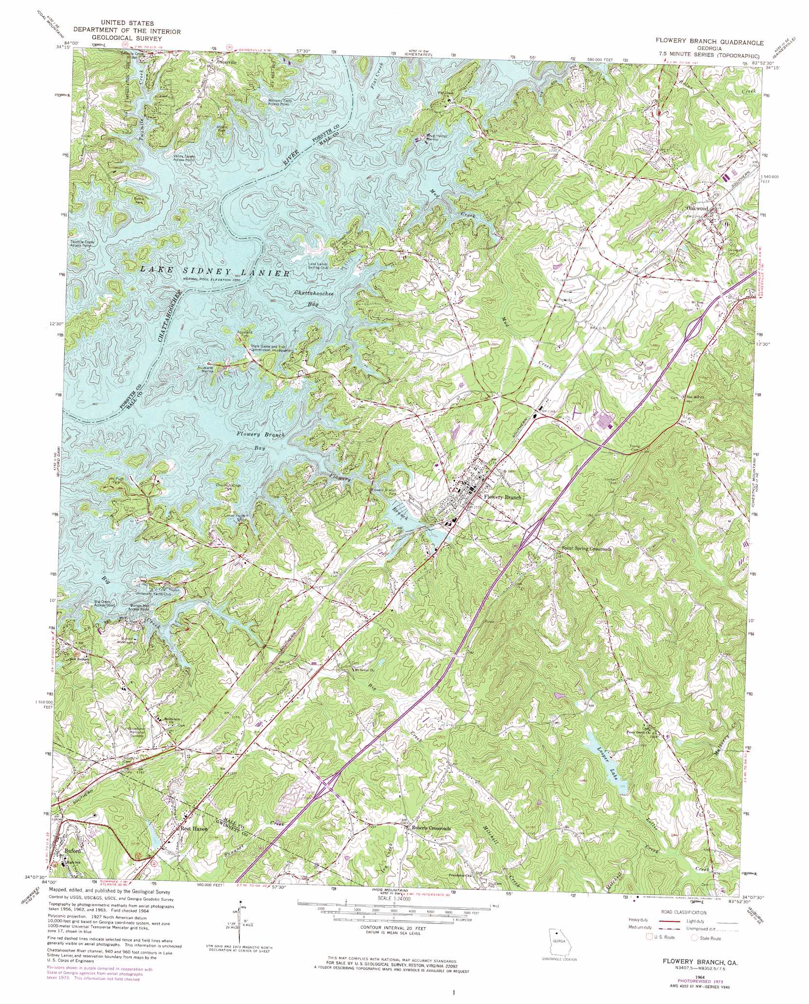
USGS Topo Quad 34083b8 - 1:24,000 scale
| Topo Map Name: | Flowery Branch |
| USGS Topo Quad ID: | 34083b8 |
| Print Size: | ca. 21 1/4" wide x 27" high |
| Southeast Coordinates: | 34.125° N latitude / 83.875° W longitude |
| Map Center Coordinates: | 34.1875° N latitude / 83.9375° W longitude |
| U.S. State: | GA |
| Filename: | o34083b8.jpg |
| Download Map JPG Image: | Flowery Branch topo map 1:24,000 scale |
| Map Type: | Topographic |
| Topo Series: | 7.5´ |
| Map Scale: | 1:24,000 |
| Source of Map Images: | United States Geological Survey (USGS) |
| Alternate Map Versions: |
Flowery Branch GA 1964, updated 1965 Download PDF Buy paper map Flowery Branch GA 1964, updated 1972 Download PDF Buy paper map Flowery Branch GA 1964, updated 1974 Download PDF Buy paper map Flowery Branch GA 1964, updated 1975 Download PDF Buy paper map Flowery Branch GA 1999, updated 2003 Download PDF Buy paper map Flowery Branch GA 2011 Download PDF Buy paper map Flowery Branch GA 2014 Download PDF Buy paper map |
1:24,000 Topo Quads surrounding Flowery Branch
Juno |
Dawsonville |
Murrayville |
Clermont |
Lula |
Matt |
Coal Mountain |
Chestatee |
Gainesville |
Gillsville |
Cumming |
Buford Dam |
Flowery Branch |
Chestnut Mountain |
Pendergrass |
Duluth |
Suwanee |
Hog Mountain |
Auburn |
Winder North |
Norcross |
Luxomni |
Lawrenceville |
Bold Springs |
Winder South |
> Back to 34083a1 at 1:100,000 scale
> Back to 34082a1 at 1:250,000 scale
> Back to U.S. Topo Maps home
Flowery Branch topo map: Gazetteer
Flowery Branch: Bays
Chattahoochee Bay elevation 326m 1069′Flowery Branch Bay elevation 326m 1069′
Flowery Branch: Bridges
Twomile Creek Bridge elevation 327m 1072′Flowery Branch: Crossings
Exit 2 elevation 373m 1223′Exit 3 elevation 347m 1138′
Gaines Ferry (historical) elevation 326m 1069′
Goddards Ford (historical) elevation 326m 1069′
Lights Ferry (historical) elevation 326m 1069′
Winns Ferry (historical) elevation 326m 1069′
Flowery Branch: Dams
Looper Lake Dam elevation 277m 908′Flowery Branch: Parks
Alberta Banks Park elevation 379m 1243′Aqualand Park elevation 334m 1095′
Athens Park elevation 333m 1092′
Bethel Park elevation 326m 1069′
Chestnut Ridge Park elevation 341m 1118′
Flowery Branch Commercial Historic District elevation 343m 1125′
Flowery Branch Park elevation 329m 1079′
Old Federal Road Park elevation 330m 1082′
Van Pugh Park elevation 342m 1122′
Flowery Branch: Populated Places
Balus Creek elevation 342m 1122′Beard elevation 365m 1197′
Bentwood elevation 371m 1217′
Byers elevation 365m 1197′
Flat Creek elevation 353m 1158′
Flowery Branch elevation 342m 1122′
Forest Park elevation 360m 1181′
Gay Lan elevation 335m 1099′
Green Crossing elevation 363m 1190′
Green Meadows elevation 356m 1167′
Hammer elevation 355m 1164′
Hidden Harbor elevation 365m 1197′
Holiday Meadows elevation 362m 1187′
Holiday Villa elevation 354m 1161′
Holland elevation 373m 1223′
Johnson elevation 348m 1141′
Lake Forest elevation 366m 1200′
Loch Arbor elevation 350m 1148′
McClure elevation 348m 1141′
Misty Cove elevation 340m 1115′
Oakwood elevation 353m 1158′
Olde Federal Pointe elevation 335m 1099′
Oscarville elevation 362m 1187′
Pleasant View elevation 359m 1177′
Quail Run elevation 347m 1138′
Raintree East elevation 368m 1207′
Raintree West elevation 360m 1181′
Reed elevation 357m 1171′
Rest Haven elevation 336m 1102′
Roberts Crossroads elevation 378m 1240′
Sagefield elevation 363m 1190′
Sallee Heights elevation 353m 1158′
Scotts Cove elevation 344m 1128′
Southgate elevation 372m 1220′
Spout Spring Crossroads elevation 365m 1197′
Trudy Estates elevation 346m 1135′
Vista Brook elevation 357m 1171′
Waverly Way elevation 361m 1184′
Wayne elevation 348m 1141′
Woodbridge elevation 366m 1200′
Woodlake elevation 339m 1112′
Flowery Branch: Post Offices
Flowery Branch Post Office elevation 346m 1135′Flowery Branch: Reservoirs
Looper Lake elevation 277m 908′Looper Lake Dam elevation 342m 1122′
Flowery Branch: Streams
Big Creek elevation 326m 1069′Flat Creek elevation 326m 1069′
Flowery Branch elevation 326m 1069′
Lott Creek elevation 268m 879′
Mitchell Creek elevation 267m 875′
Mud Creek elevation 326m 1069′
Twomile Creek elevation 326m 1069′
Flowery Branch: Summits
Fox Hill elevation 389m 1276′Flowery Branch digital topo map on disk
Buy this Flowery Branch topo map showing relief, roads, GPS coordinates and other geographical features, as a high-resolution digital map file on DVD:
South Carolina, Western North Carolina & Northeastern Georgia
Buy digital topo maps: South Carolina, Western North Carolina & Northeastern Georgia