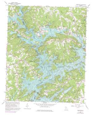
Chestatee Topo Map Georgia
To zoom in, hover over the map of Chestatee
USGS Topo Quad 34083c8 - 1:24,000 scale
| Topo Map Name: | Chestatee |
| USGS Topo Quad ID: | 34083c8 |
| Print Size: | ca. 21 1/4" wide x 27" high |
| Southeast Coordinates: | 34.25° N latitude / 83.875° W longitude |
| Map Center Coordinates: | 34.3125° N latitude / 83.9375° W longitude |
| U.S. State: | GA |
| Filename: | o34083c8.jpg |
| Download Map JPG Image: | Chestatee topo map 1:24,000 scale |
| Map Type: | Topographic |
| Topo Series: | 7.5´ |
| Map Scale: | 1:24,000 |
| Source of Map Images: | United States Geological Survey (USGS) |
| Alternate Map Versions: |
Chestatee GA 1964, updated 1965 Download PDF Buy paper map Chestatee GA 1964, updated 1973 Download PDF Buy paper map Chestatee GA 1964, updated 1974 Download PDF Buy paper map Chestatee GA 2011 Download PDF Buy paper map Chestatee GA 2014 Download PDF Buy paper map |
1:24,000 Topo Quads surrounding Chestatee
> Back to 34083a1 at 1:100,000 scale
> Back to 34082a1 at 1:250,000 scale
> Back to U.S. Topo Maps home
Chestatee topo map: Gazetteer
Chestatee: Airports
Latham Creek Heliport elevation 337m 1105′Chestatee: Bays
Chestatee Bay elevation 326m 1069′Chestatee: Bridges
Bolding Bridge (historical) elevation 326m 1069′Bolling Bridge elevation 326m 1069′
Browns Bridge elevation 326m 1069′
Davis Bridge Access Point elevation 331m 1085′
Keith Bridge (historical) elevation 326m 1069′
Keith Bridge Access Point elevation 326m 1069′
Lanier Bridge elevation 326m 1069′
Nix Bridge Access Point elevation 329m 1079′
Chestatee: Crossings
Goddards Old Ford elevation 326m 1069′Keith Ferry (historical) elevation 326m 1069′
Rocky Bottom Ford (historical) elevation 326m 1069′
Shallow Ford (historical) elevation 326m 1069′
Wooley Ford (historical) elevation 326m 1069′
Chestatee: Parks
Cool Springs Access Point elevation 331m 1085′Gainesville Park Access Point elevation 331m 1085′
Johnson Creek Access Point elevation 326m 1069′
Latham Creek Access Point elevation 326m 1069′
Upper Latham Creek Access Point elevation 326m 1069′
Chestatee: Populated Places
Absalom (historical) elevation 361m 1184′Barnes elevation 355m 1164′
Beach Haven Heights elevation 348m 1141′
Cameron Point elevation 360m 1181′
Cherokee Hills elevation 360m 1181′
Cherokee Trail elevation 364m 1194′
Chestatee elevation 385m 1263′
Chestatee North elevation 334m 1095′
Crown Point elevation 360m 1181′
Fox Trace elevation 359m 1177′
Fran Mar Heights elevation 352m 1154′
Holiday Heights elevation 367m 1204′
Holiday Hills elevation 370m 1213′
Lake Farm elevation 353m 1158′
Lake Ranch elevation 351m 1151′
Lanier Northwest elevation 409m 1341′
Looper Lake elevation 357m 1171′
Maple Forge elevation 372m 1220′
McEver elevation 379m 1243′
Mill Ridge elevation 346m 1135′
Moore elevation 346m 1135′
Mountain View elevation 366m 1200′
Mundys Point elevation 344m 1128′
Pine Forest elevation 347m 1138′
Pine Haven elevation 363m 1190′
Pine Hills elevation 359m 1177′
Pinecrest Heights elevation 362m 1187′
Point View Landing elevation 355m 1164′
Reed elevation 365m 1197′
Sardis Shores elevation 342m 1122′
Serene Shores elevation 369m 1210′
Sidney on Lanier elevation 374m 1227′
Springdale elevation 357m 1171′
Springdale Forest elevation 359m 1177′
Summer Point elevation 367m 1204′
Tanner elevation 373m 1223′
Trudy elevation 366m 1200′
Twin Rivers elevation 361m 1184′
Venture Cove elevation 340m 1115′
Vickers elevation 351m 1151′
Weatherford elevation 360m 1181′
Westview elevation 348m 1141′
White elevation 353m 1158′
Whitmire elevation 349m 1145′
Wolfs Head elevation 349m 1145′
Chestatee: Streams
Balus Creek elevation 326m 1069′Chestatee River elevation 326m 1069′
Johnson Creek elevation 326m 1069′
Latham Creek elevation 326m 1069′
Martin Creek elevation 326m 1069′
Sardis Creek elevation 326m 1069′
Taylor Creek elevation 326m 1069′
Thompson Creek elevation 326m 1069′
Chestatee: Summits
Banks Mountain elevation 374m 1227′Chestatee digital topo map on disk
Buy this Chestatee topo map showing relief, roads, GPS coordinates and other geographical features, as a high-resolution digital map file on DVD:
South Carolina, Western North Carolina & Northeastern Georgia
Buy digital topo maps: South Carolina, Western North Carolina & Northeastern Georgia


