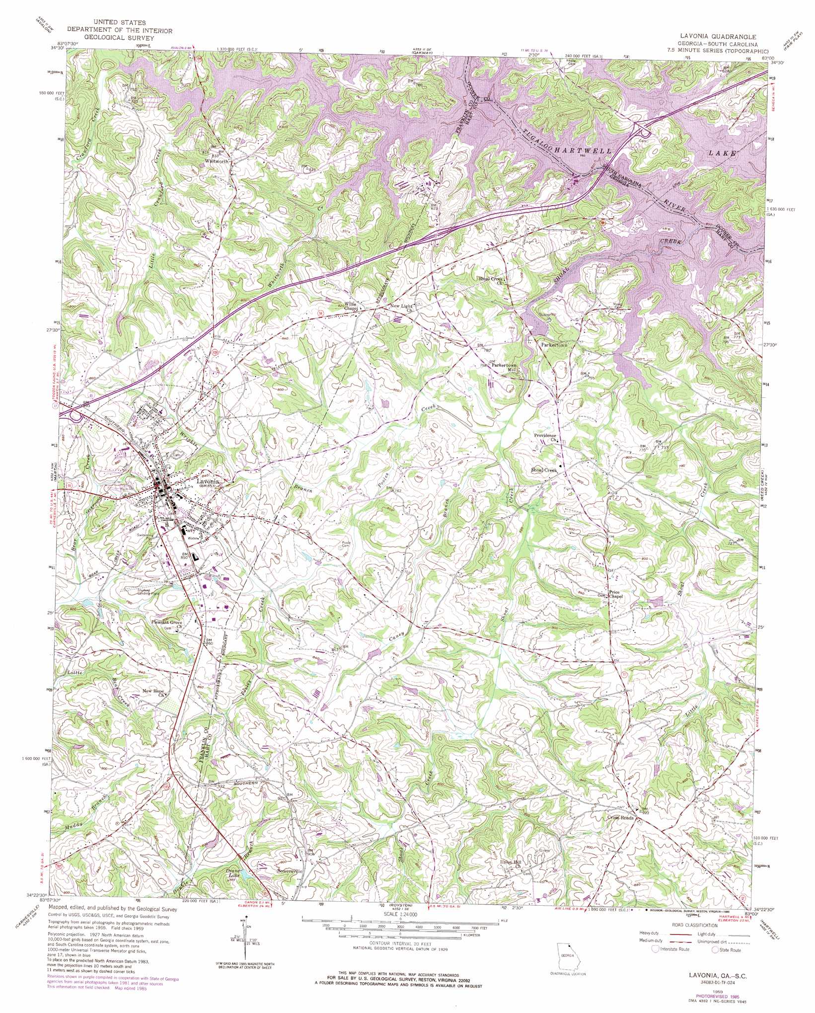
Lavonia Topo Map Georgia
To zoom in, hover over the map of Lavonia
USGS Topo Quad 34083d1 - 1:24,000 scale
| Topo Map Name: | Lavonia |
| USGS Topo Quad ID: | 34083d1 |
| Print Size: | ca. 21 1/4" wide x 27" high |
| Southeast Coordinates: | 34.375° N latitude / 83° W longitude |
| Map Center Coordinates: | 34.4375° N latitude / 83.0625° W longitude |
| U.S. States: | GA, SC |
| Filename: | o34083d1.jpg |
| Download Map JPG Image: | Lavonia topo map 1:24,000 scale |
| Map Type: | Topographic |
| Topo Series: | 7.5´ |
| Map Scale: | 1:24,000 |
| Source of Map Images: | United States Geological Survey (USGS) |
| Alternate Map Versions: |
Lavonia GA 1959, updated 1961 Download PDF Buy paper map Lavonia GA 1959, updated 1975 Download PDF Buy paper map Lavonia GA 1985, updated 1986 Download PDF Buy paper map Lavonia GA 2011 Download PDF Buy paper map Lavonia GA 2014 Download PDF Buy paper map |
1:24,000 Topo Quads surrounding Lavonia
Tugaloo Lake |
Holly Springs |
Westminster |
Seneca |
Clemson |
Toccoa |
Avalon |
Oakway |
Fair Play |
La France |
Red Hill |
Martin |
Lavonia |
Reed Creek |
Hartwell Ne |
Ashland |
Carnesville |
Royston |
Hartwell |
Hartwell Dam |
Ila |
Danielsville North |
Bowman |
Dewy Rose |
Rock Branch |
> Back to 34083a1 at 1:100,000 scale
> Back to 34082a1 at 1:250,000 scale
> Back to U.S. Topo Maps home
Lavonia topo map: Gazetteer
Lavonia: Airports
Shuford Municipal Airport elevation 245m 803′Lavonia: Bridges
Knox Bridge (historical) elevation 201m 659′Knox Bridge (historical) elevation 201m 659′
Lavonia: Crossings
Cleveland Ferry (historical) elevation 201m 659′Cleveland Ferry (historical) elevation 201m 659′
Exit 58 elevation 267m 875′
Exit 59 elevation 232m 761′
Interchange 1 elevation 216m 708′
Lavonia: Mines
Taylor Mine elevation 265m 869′Lavonia: Parks
Fred E Lee Memorial elevation 244m 800′Jones Street Residential Historic District elevation 258m 846′
Lavonia Commercial Historic District elevation 261m 856′
Tugaloo State Park elevation 212m 695′
West Avenue-Roberts Street Residential Historic District elevation 261m 856′
Lavonia: Populated Places
Cross Roads elevation 285m 935′Gumlog elevation 223m 731′
Lavonia elevation 260m 853′
Parkertown elevation 215m 705′
Parkertown Mill elevation 207m 679′
Shoal Creek elevation 236m 774′
Whitworth elevation 256m 839′
Lavonia: Reservoirs
Deans Lake elevation 248m 813′Lavonia: Streams
Caney Branch elevation 212m 695′Crawford Creek elevation 201m 659′
Gum Log Creek elevation 201m 659′
Little Crawford Creek elevation 202m 662′
Little Shoal Creek elevation 201m 659′
Pooles Creek elevation 210m 688′
Shoal Creek elevation 201m 659′
Whitworth Creek elevation 201m 659′
Wrights Branch elevation 213m 698′
Lavonia digital topo map on disk
Buy this Lavonia topo map showing relief, roads, GPS coordinates and other geographical features, as a high-resolution digital map file on DVD:
South Carolina, Western North Carolina & Northeastern Georgia
Buy digital topo maps: South Carolina, Western North Carolina & Northeastern Georgia