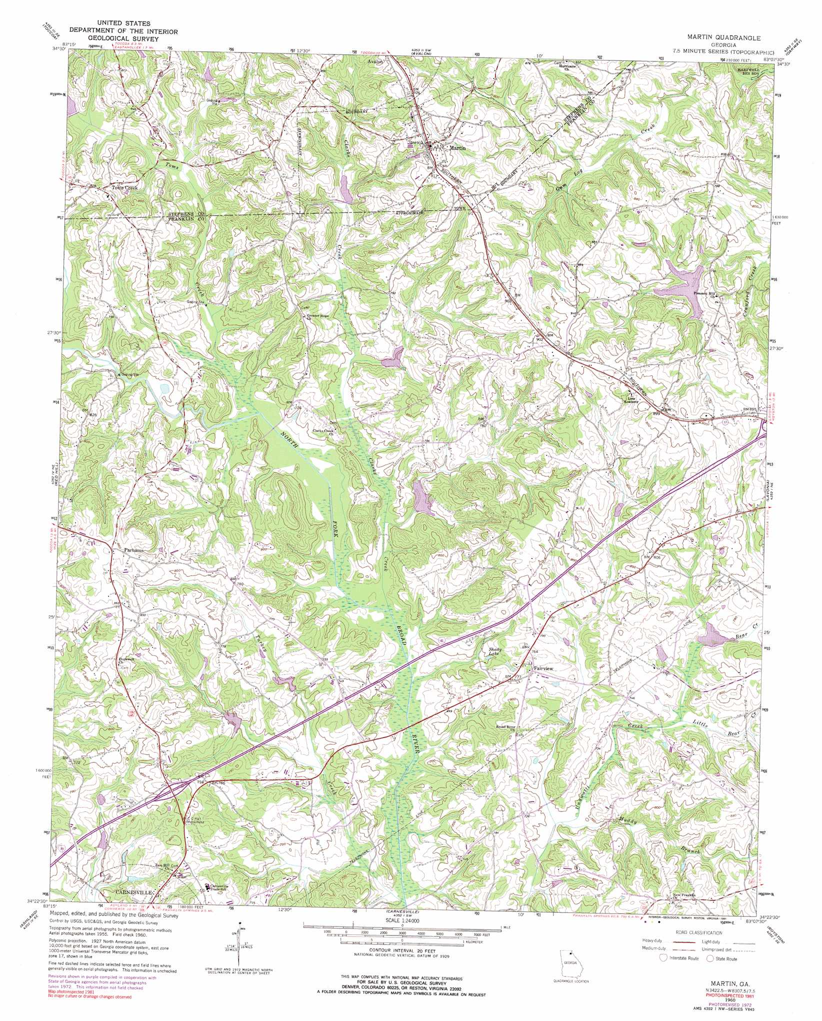
Martin Topo Map Georgia
To zoom in, hover over the map of Martin
USGS Topo Quad 34083d2 - 1:24,000 scale
| Topo Map Name: | Martin |
| USGS Topo Quad ID: | 34083d2 |
| Print Size: | ca. 21 1/4" wide x 27" high |
| Southeast Coordinates: | 34.375° N latitude / 83.125° W longitude |
| Map Center Coordinates: | 34.4375° N latitude / 83.1875° W longitude |
| U.S. State: | GA |
| Filename: | o34083d2.jpg |
| Download Map JPG Image: | Martin topo map 1:24,000 scale |
| Map Type: | Topographic |
| Topo Series: | 7.5´ |
| Map Scale: | 1:24,000 |
| Source of Map Images: | United States Geological Survey (USGS) |
| Alternate Map Versions: |
Martin GA 1960, updated 1962 Download PDF Buy paper map Martin GA 1960, updated 1975 Download PDF Buy paper map Martin GA 1960, updated 1991 Download PDF Buy paper map Martin GA 2011 Download PDF Buy paper map Martin GA 2014 Download PDF Buy paper map |
1:24,000 Topo Quads surrounding Martin
Tallulah Falls |
Tugaloo Lake |
Holly Springs |
Westminster |
Seneca |
Ayersville |
Toccoa |
Avalon |
Oakway |
Fair Play |
Russell Lake |
Red Hill |
Martin |
Lavonia |
Reed Creek |
Homer |
Ashland |
Carnesville |
Royston |
Hartwell |
Commerce |
Ila |
Danielsville North |
Bowman |
Dewy Rose |
> Back to 34083a1 at 1:100,000 scale
> Back to 34082a1 at 1:250,000 scale
> Back to U.S. Topo Maps home
Martin topo map: Gazetteer
Martin: Crossings
Exit 57 elevation 250m 820′Martin: Dams
Lavonia Water Works Dam elevation 229m 751′North Broad River Structure 33 Dam elevation 208m 682′
North Broad River Structure Four Dam elevation 217m 711′
North Broad River Structure Number 32 Dam elevation 216m 708′
North Broad River Structure Number 38 Dam elevation 223m 731′
North Broad River Structure Number Five Dam elevation 214m 702′
North Broad River Structure Number One Dam elevation 223m 731′
North Fork Broad River Dam Number 13 elevation 230m 754′
North Fork Broad River Structure 11 Dam elevation 230m 754′
North Fork Broad River Structure 14 Dam elevation 226m 741′
North Fork Broad River Structure 15 Dam elevation 240m 787′
Martin: Parks
C C Hall Monument elevation 244m 800′Martin: Populated Places
Fairview elevation 232m 761′Martin elevation 280m 918′
Parhams elevation 267m 875′
Salubrity (historical) elevation 238m 780′
Toms Creek elevation 257m 843′
Martin: Reservoirs
Ayers Pond elevation 226m 741′Lavonia Water Works Lake elevation 229m 751′
North Fork Broad River elevation 230m 754′
Reservoir 11 elevation 230m 754′
Reservoir 14 elevation 226m 741′
Reservoir 15 elevation 240m 787′
Reservoir 32 elevation 216m 708′
Reservoir 33 elevation 208m 682′
Reservoir 38 elevation 223m 731′
Reservoir Five elevation 214m 702′
Reservoir Four elevation 217m 711′
Reservoir Number One elevation 223m 731′
Shady Lake elevation 218m 715′
Martin: Streams
Bear Creek elevation 223m 731′Clarks Creek elevation 201m 659′
Little Bear Creek elevation 219m 718′
Muddy Branch elevation 207m 679′
Toms Creek elevation 207m 679′
Turkey Creek elevation 195m 639′
Martin digital topo map on disk
Buy this Martin topo map showing relief, roads, GPS coordinates and other geographical features, as a high-resolution digital map file on DVD:
South Carolina, Western North Carolina & Northeastern Georgia
Buy digital topo maps: South Carolina, Western North Carolina & Northeastern Georgia