Ayersville Topo Map Georgia
To zoom in, hover over the map of Ayersville
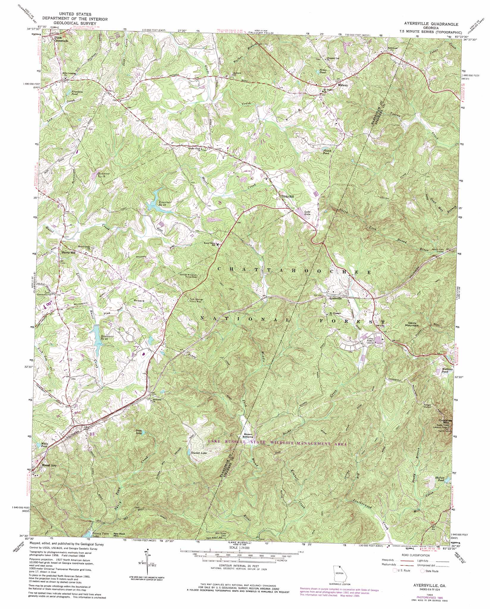
USGS Topo Quad 34083e4 - 1:24,000 scale
| Topo Map Name: | Ayersville |
| USGS Topo Quad ID: | 34083e4 |
| Print Size: | ca. 21 1/4" wide x 27" high |
| Southeast Coordinates: | 34.5° N latitude / 83.375° W longitude |
| Map Center Coordinates: | 34.5625° N latitude / 83.4375° W longitude |
| U.S. State: | GA |
| Filename: | o34083e4.jpg |
| Download Map JPG Image: | Ayersville topo map 1:24,000 scale |
| Map Type: | Topographic |
| Topo Series: | 7.5´ |
| Map Scale: | 1:24,000 |
| Source of Map Images: | United States Geological Survey (USGS) |
| Alternate Map Versions: |
Ayersville GA 1964, updated 1965 Download PDF Buy paper map Ayersville GA 1964, updated 1979 Download PDF Buy paper map Ayersville GA 1964, updated 1986 Download PDF Buy paper map Ayersville GA 2011 Download PDF Buy paper map Ayersville GA 2014 Download PDF Buy paper map |
| FStopo: | US Forest Service topo Ayersville is available: Download FStopo PDF Download FStopo TIF |
1:24,000 Topo Quads surrounding Ayersville
Tray Mountain |
Lake Burton |
Tiger |
Rainy Mountain |
Whetstone |
Helen |
Clarkesville Ne |
Tallulah Falls |
Tugaloo Lake |
Holly Springs |
Leaf |
Clarkesville |
Ayersville |
Toccoa |
Avalon |
Lula |
Baldwin |
Russell Lake |
Red Hill |
Martin |
Gillsville |
Maysville |
Homer |
Ashland |
Carnesville |
> Back to 34083e1 at 1:100,000 scale
> Back to 34082a1 at 1:250,000 scale
> Back to U.S. Topo Maps home
Ayersville topo map: Gazetteer
Ayersville: Bends
Brown Bottoms elevation 292m 958′Ayersville: Bridges
North Fork Trestle elevation 285m 935′Ayersville: Dams
Hazel Creek Structure 12 Dam elevation 418m 1371′Hazel Creek Structure 19 Dam elevation 415m 1361′
Hazel Creek Structure 21 Dam elevation 419m 1374′
North Fork Broad River Structure Eight Dam elevation 262m 859′
Ayersville: Parks
Lake Russell State Wildlife Management Area elevation 294m 964′Locust Stake ORV Area elevation 362m 1187′
Ayersville: Populated Places
Ayersville elevation 374m 1227′Dicks Hill elevation 464m 1522′
Midway elevation 476m 1561′
New Switzerland elevation 439m 1440′
Shorts Mill elevation 409m 1341′
Stottsville elevation 456m 1496′
Ayersville: Reservoirs
Ducket Lake elevation 426m 1397′Franklin Pond elevation 436m 1430′
Irvin Lake elevation 403m 1322′
Lake Irvin elevation 461m 1512′
Nems Pond elevation 456m 1496′
Penick Pond elevation 454m 1489′
Reservoir 12 elevation 418m 1371′
Reservoir 19 elevation 416m 1364′
Reservoir 21 elevation 419m 1374′
Reservoir Number 12 elevation 418m 1371′
Reservoir Number 19 elevation 415m 1361′
Reservoir Number 21 elevation 419m 1374′
Shiflett Pond elevation 250m 820′
Warren Franklin Pond elevation 428m 1404′
Watkins Pond elevation 262m 859′
Wells Pond elevation 441m 1446′
Ayersville: Streams
Dicks Creek elevation 291m 954′Erady Branch elevation 234m 767′
Kimbell Creek elevation 271m 889′
Mill Creek elevation 228m 748′
Pink Dill Branch elevation 414m 1358′
Rock Ford Branch elevation 419m 1374′
Ayersville: Summits
Currahee Mountain elevation 517m 1696′Davis Mountain elevation 411m 1348′
Ayersville digital topo map on disk
Buy this Ayersville topo map showing relief, roads, GPS coordinates and other geographical features, as a high-resolution digital map file on DVD:
South Carolina, Western North Carolina & Northeastern Georgia
Buy digital topo maps: South Carolina, Western North Carolina & Northeastern Georgia