Tugaloo Lake Topo Map South Carolina
To zoom in, hover over the map of Tugaloo Lake
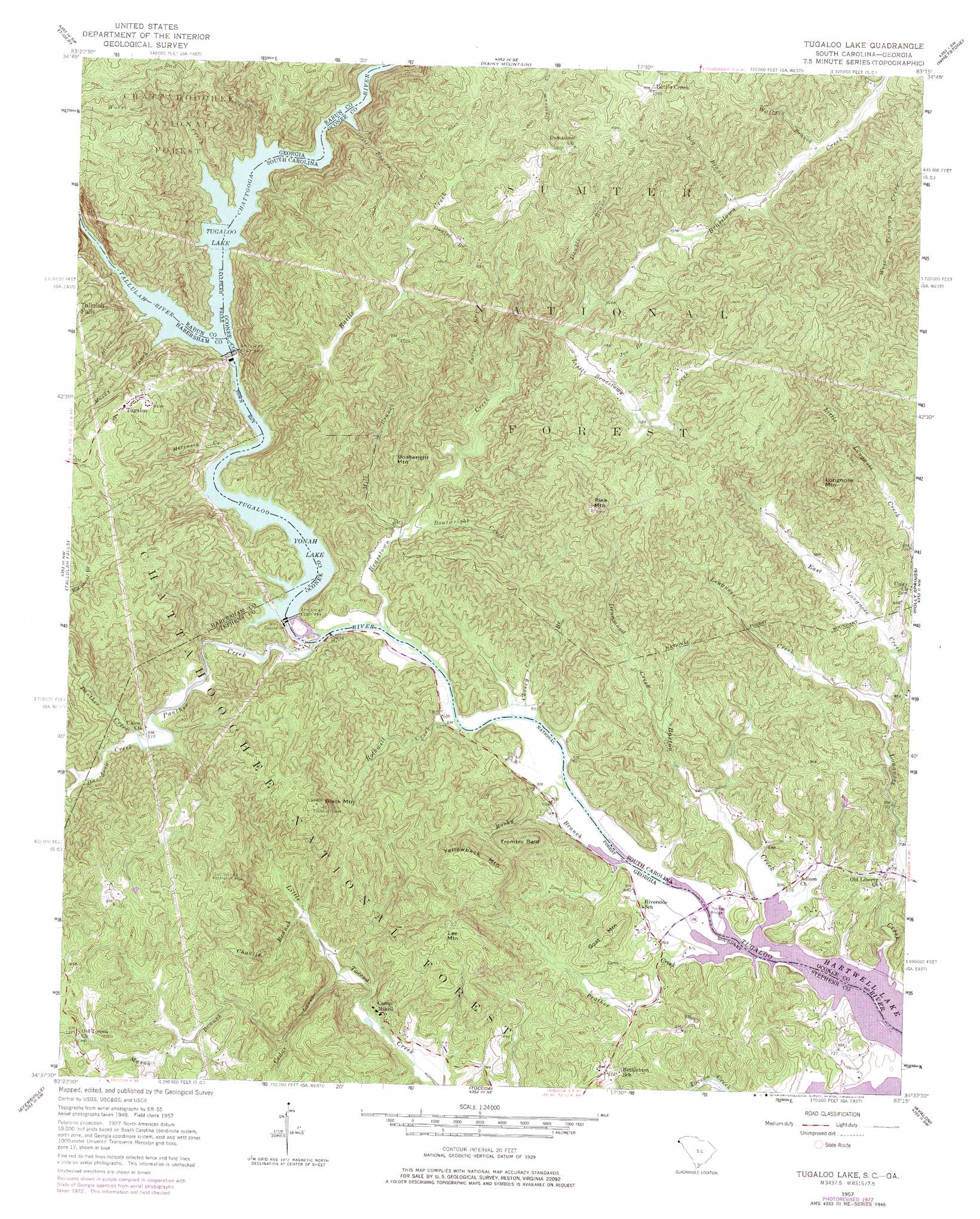
USGS Topo Quad 34083f3 - 1:24,000 scale
| Topo Map Name: | Tugaloo Lake |
| USGS Topo Quad ID: | 34083f3 |
| Print Size: | ca. 21 1/4" wide x 27" high |
| Southeast Coordinates: | 34.625° N latitude / 83.25° W longitude |
| Map Center Coordinates: | 34.6875° N latitude / 83.3125° W longitude |
| U.S. States: | SC, GA |
| Filename: | o34083f3.jpg |
| Download Map JPG Image: | Tugaloo Lake topo map 1:24,000 scale |
| Map Type: | Topographic |
| Topo Series: | 7.5´ |
| Map Scale: | 1:24,000 |
| Source of Map Images: | United States Geological Survey (USGS) |
| Alternate Map Versions: |
Tugaloo Lake GA 1957, updated 1958 Download PDF Buy paper map Tugaloo Lake GA 1957, updated 1967 Download PDF Buy paper map Tugaloo Lake GA 1957, updated 1975 Download PDF Buy paper map Tugaloo Lake GA 1957, updated 1975 Download PDF Buy paper map Tugaloo Lake GA 1997, updated 2001 Download PDF Buy paper map Tugaloo Lake GA 2011 Download PDF Buy paper map Tugaloo Lake GA 2014 Download PDF Buy paper map |
| FStopo: | US Forest Service topo Tugaloo Lake is available: Download FStopo PDF Download FStopo TIF |
1:24,000 Topo Quads surrounding Tugaloo Lake
Hightower Bald |
Dillard |
Rabun Bald |
Satolah |
Tamassee |
Lake Burton |
Tiger |
Rainy Mountain |
Whetstone |
Walhalla |
Clarkesville Ne |
Tallulah Falls |
Tugaloo Lake |
Holly Springs |
Westminster |
Clarkesville |
Ayersville |
Toccoa |
Avalon |
Oakway |
Baldwin |
Russell Lake |
Red Hill |
Martin |
Lavonia |
> Back to 34083e1 at 1:100,000 scale
> Back to 34082a1 at 1:250,000 scale
> Back to U.S. Topo Maps home
Tugaloo Lake topo map: Gazetteer
Tugaloo Lake: Bridges
Prather Bridge elevation 202m 662′Prather Bridge elevation 202m 662′
Tugaloo Lake: Crossings
McCracken Ford (historical) elevation 272m 892′Tugaloo Lake: Dams
Roletter Pond Dam D-1664 elevation 353m 1158′Tugaloo Dam elevation 272m 892′
Yonah Dam elevation 225m 738′
Tugaloo Lake: Parks
Cool Springs Recreation Area elevation 429m 1407′Tugaloo Lake: Populated Places
Battle Creek elevation 492m 1614′Tugaloo elevation 452m 1482′
Tugaloo Lake: Reservoirs
Lake Yonah elevation 207m 679′Roletter Pond elevation 353m 1158′
Tugaloo Lake elevation 272m 892′
Yonah Lake elevation 221m 725′
Tugaloo Lake: Streams
Bad Creek elevation 293m 961′Barton Creek elevation 202m 662′
Battle Creek elevation 228m 748′
Big Branch elevation 329m 1079′
Big Shoal Branch elevation 268m 879′
Black Branch elevation 274m 898′
Boatwright Creek elevation 211m 692′
Brasstown Creek elevation 205m 672′
Cedar Creek elevation 238m 780′
Charlie Branch elevation 250m 820′
Chattooga River elevation 272m 892′
Cherry Cove Branch elevation 206m 675′
Daniel Branch elevation 414m 1358′
Davidson Creek elevation 219m 718′
Devil Den Creek elevation 219m 718′
Devil Hole Branch elevation 354m 1161′
Devils Branch elevation 272m 892′
Double Branch elevation 315m 1033′
Drummond Creek elevation 225m 738′
East Longnose Creek elevation 220m 721′
Joe Branch elevation 334m 1095′
Little Brasstown Creek elevation 314m 1030′
Longnose Creek elevation 202m 662′
Mason Branch elevation 309m 1013′
Mill Branch elevation 211m 692′
Moccasin Creek elevation 228m 748′
Moody Branch elevation 275m 902′
Panther Creek elevation 206m 675′
Porter Branch elevation 231m 757′
Prather Creek elevation 202m 662′
Rocky Branch elevation 204m 669′
Rothwell Creek elevation 203m 666′
Tallulah River elevation 272m 892′
Toccoa Creek elevation 204m 669′
Wallace Branch elevation 341m 1118′
Worse Creek elevation 273m 895′
Tugaloo Lake: Summits
Abram Mountain elevation 460m 1509′Black Mountain elevation 464m 1522′
Boatwright Mountain elevation 369m 1210′
Goat Mountain elevation 282m 925′
Lee Mountain elevation 379m 1243′
Longnose Mountain elevation 531m 1742′
Pine Mountain elevation 520m 1706′
Trembly Bald elevation 351m 1151′
Yellowback Mountain elevation 398m 1305′
Tugaloo Lake: Valleys
Tallulah Gorge elevation 272m 892′Tugaloo Lake digital topo map on disk
Buy this Tugaloo Lake topo map showing relief, roads, GPS coordinates and other geographical features, as a high-resolution digital map file on DVD:
South Carolina, Western North Carolina & Northeastern Georgia
Buy digital topo maps: South Carolina, Western North Carolina & Northeastern Georgia