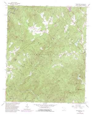
Whetstone Topo Map South Carolina
To zoom in, hover over the map of Whetstone
USGS Topo Quad 34083g2 - 1:24,000 scale
| Topo Map Name: | Whetstone |
| USGS Topo Quad ID: | 34083g2 |
| Print Size: | ca. 21 1/4" wide x 27" high |
| Southeast Coordinates: | 34.75° N latitude / 83.125° W longitude |
| Map Center Coordinates: | 34.8125° N latitude / 83.1875° W longitude |
| U.S. States: | SC, GA |
| Filename: | o34083g2.jpg |
| Download Map JPG Image: | Whetstone topo map 1:24,000 scale |
| Map Type: | Topographic |
| Topo Series: | 7.5´ |
| Map Scale: | 1:24,000 |
| Source of Map Images: | United States Geological Survey (USGS) |
| Alternate Map Versions: |
Whetstone SC 1961, updated 1964 Download PDF Buy paper map Whetstone SC 1961, updated 1973 Download PDF Buy paper map Whetstone SC 1961, updated 1981 Download PDF Buy paper map Whetstone SC 1961, updated 1988 Download PDF Buy paper map Whetstone SC 1997, updated 2001 Download PDF Buy paper map Whetstone SC 2011 Download PDF Buy paper map Whetstone SC 2014 Download PDF Buy paper map |
| FStopo: | US Forest Service topo Whetstone is available: Download FStopo PDF Download FStopo TIF |
1:24,000 Topo Quads surrounding Whetstone
> Back to 34083e1 at 1:100,000 scale
> Back to 34082a1 at 1:250,000 scale
> Back to U.S. Topo Maps home
Whetstone topo map: Gazetteer
Whetstone: Bridges
Blackwell Bridge elevation 439m 1440′Cassidy Bridge elevation 374m 1227′
Land Bridge elevation 450m 1476′
Whetstone: Crossings
Sandy Ford elevation 428m 1404′Whetstone: Dams
Crystal Lake Dam D-1645 elevation 477m 1564′Lake Jemike Number One Dam D-1648 elevation 324m 1062′
Lake Jemike Number Two Dam D-1649 elevation 340m 1115′
Lake Leroy Dam D-1639 elevation 515m 1689′
South Carolina Noname 37030 D-1644 Dam elevation 504m 1653′
Whetstone: Gaps
Mongold Gap elevation 568m 1863′Rocky Gap elevation 567m 1860′
Whetstone: Parks
Chauga River Scenic Area elevation 445m 1459′Whetstone: Populated Places
Whetstone elevation 516m 1692′Whetstone: Reservoirs
Crystal Lake elevation 477m 1564′Crystal Lake elevation 518m 1699′
Lake Jemike elevation 324m 1062′
Lake Leroy elevation 515m 1689′
Whetstone: Streams
Baker Branch elevation 376m 1233′Bone Camp Creek elevation 397m 1302′
Cedar Creek elevation 277m 908′
Chambers Branch elevation 413m 1354′
Coppermine Branch elevation 407m 1335′
Crooked Creek elevation 290m 951′
Dicks Creek elevation 439m 1440′
Doran Creek elevation 316m 1036′
Double Branch elevation 364m 1194′
East Village Creek elevation 469m 1538′
Flint Creek elevation 289m 948′
Grapevine Branch elevation 461m 1512′
Harts Branch elevation 505m 1656′
Hell Hole Creek elevation 391m 1282′
Hickory Flat Branch elevation 382m 1253′
Jerry Creek elevation 451m 1479′
Laurel Creek elevation 353m 1158′
Limestone Creek elevation 409m 1341′
Long Branch elevation 473m 1551′
Mill Creek elevation 375m 1230′
Miller Field Branch elevation 451m 1479′
Orchard Branch elevation 481m 1578′
Orrs Mill Creek elevation 486m 1594′
Otter Creek elevation 324m 1062′
Rhoda Branch elevation 374m 1227′
Rock Creek elevation 429m 1407′
Sand Branch elevation 346m 1135′
Sawyer Branch elevation 473m 1551′
Shingle Mill Branch elevation 398m 1305′
Spider Valley Creek elevation 343m 1125′
Spy Rock Creek elevation 272m 892′
Swaford Creek elevation 462m 1515′
Taylor Creek elevation 470m 1541′
Tyler Branch elevation 479m 1571′
Village Creek elevation 469m 1538′
West Village Creek elevation 478m 1568′
Whetstone Creek elevation 432m 1417′
Woodall Branch elevation 393m 1289′
Yellow Branch elevation 328m 1076′
Whetstone: Summits
Buzzard Roost Mountain elevation 529m 1735′Hurricane Mountain elevation 476m 1561′
John Mountain elevation 674m 2211′
Long Mountain elevation 623m 2043′
Moss Mountain elevation 538m 1765′
Old Field Mountain elevation 624m 2047′
Poor Mountain elevation 526m 1725′
Rich Mountain elevation 530m 1738′
Round Mountain elevation 658m 2158′
Tunnel Hill elevation 537m 1761′
Whetstone Mountain elevation 674m 2211′
Whetstone: Tunnels
Stumphouse Mountain Tunnel elevation 536m 1758′Whetstone digital topo map on disk
Buy this Whetstone topo map showing relief, roads, GPS coordinates and other geographical features, as a high-resolution digital map file on DVD:
South Carolina, Western North Carolina & Northeastern Georgia
Buy digital topo maps: South Carolina, Western North Carolina & Northeastern Georgia


