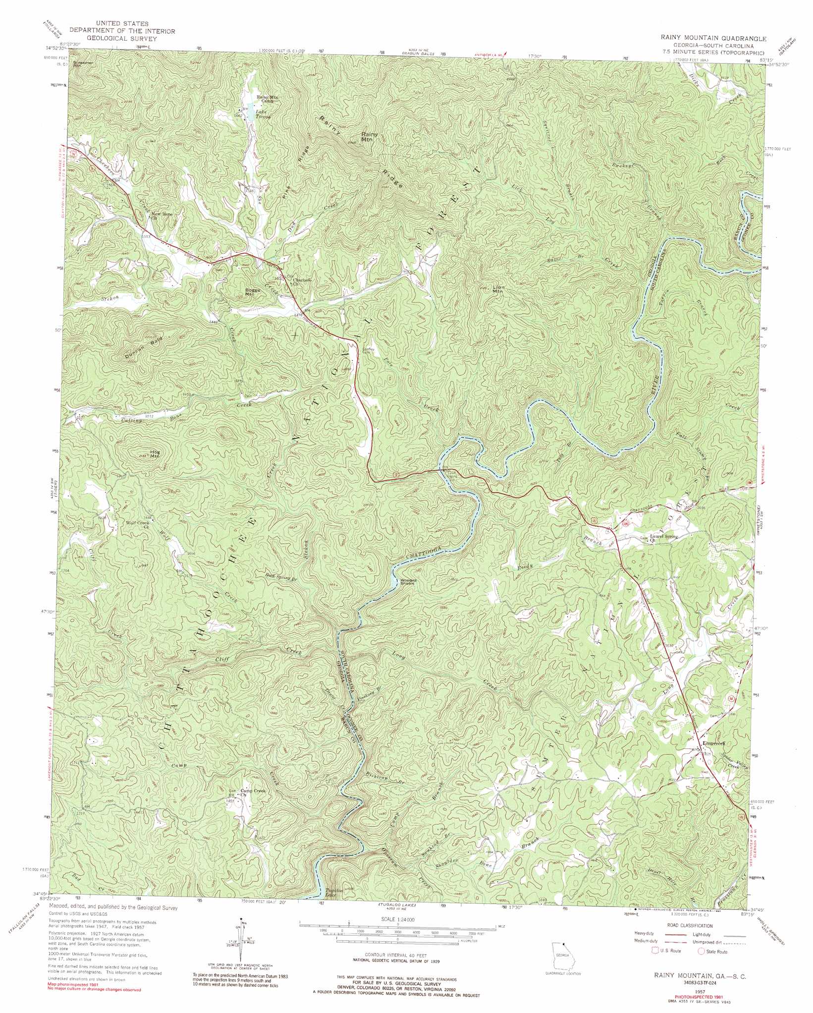
Rainy Mountain Topo Map Georgia
To zoom in, hover over the map of Rainy Mountain
USGS Topo Quad 34083g3 - 1:24,000 scale
| Topo Map Name: | Rainy Mountain |
| USGS Topo Quad ID: | 34083g3 |
| Print Size: | ca. 21 1/4" wide x 27" high |
| Southeast Coordinates: | 34.75° N latitude / 83.25° W longitude |
| Map Center Coordinates: | 34.8125° N latitude / 83.3125° W longitude |
| U.S. States: | GA, SC |
| Filename: | o34083g3.jpg |
| Download Map JPG Image: | Rainy Mountain topo map 1:24,000 scale |
| Map Type: | Topographic |
| Topo Series: | 7.5´ |
| Map Scale: | 1:24,000 |
| Source of Map Images: | United States Geological Survey (USGS) |
| Alternate Map Versions: |
Rainy Mountain GA 1957, updated 1958 Download PDF Buy paper map Rainy Mountain GA 1957, updated 1966 Download PDF Buy paper map Rainy Mountain GA 1957, updated 1990 Download PDF Buy paper map Rainy Mountain GA 1997, updated 2001 Download PDF Buy paper map Rainy Mountain GA 2011 Download PDF Buy paper map Rainy Mountain GA 2014 Download PDF Buy paper map |
| FStopo: | US Forest Service topo Rainy Mountain is available: Download FStopo PDF Download FStopo TIF |
1:24,000 Topo Quads surrounding Rainy Mountain
Rainbow Springs |
Prentiss |
Scaly Mountain |
Highlands |
Cashiers |
Hightower Bald |
Dillard |
Rabun Bald |
Satolah |
Tamassee |
Lake Burton |
Tiger |
Rainy Mountain |
Whetstone |
Walhalla |
Clarkesville Ne |
Tallulah Falls |
Tugaloo Lake |
Holly Springs |
Westminster |
Clarkesville |
Ayersville |
Toccoa |
Avalon |
Oakway |
> Back to 34083e1 at 1:100,000 scale
> Back to 34082a1 at 1:250,000 scale
> Back to U.S. Topo Maps home
Rainy Mountain topo map: Gazetteer
Rainy Mountain: Bars
Woodall Shoals elevation 335m 1099′Woodall Shoals elevation 336m 1102′
Rainy Mountain: Bridges
Highway 76 Bridge elevation 358m 1174′Iron Bridge elevation 361m 1184′
Rainy Mountain: Crossings
Rouges Ford elevation 371m 1217′Rouges Ford elevation 371m 1217′
Rainy Mountain: Dams
Horseshoe Lake Dam D-1650 elevation 496m 1627′Lake Toccoa Dam elevation 501m 1643′
Rainy Mountain: Populated Places
Longcreek elevation 495m 1624′Rainy Mountain: Reservoirs
Horseshoe Lake elevation 496m 1627′Lake Toccoa elevation 501m 1643′
Rainy Mountain: Ridges
Duncan Bald elevation 617m 2024′Pine Ridge elevation 585m 1919′
Rainy Ridge elevation 732m 2401′
Rainy Mountain: Streams
Buckeye Branch elevation 397m 1302′Camp Branch elevation 304m 997′
Camp Creek elevation 299m 980′
Chechero Creek elevation 458m 1502′
Cliff Creek elevation 315m 1033′
Cutting Bone Creek elevation 424m 1391′
Daniel Creek elevation 303m 994′
Dud Creek elevation 464m 1522′
Fall Creek elevation 387m 1269′
Fishtrap Branch elevation 306m 1003′
Lick Log Creek elevation 397m 1302′
Long Creek elevation 337m 1105′
North Fork Fall Creek elevation 433m 1420′
Opossum Creek elevation 279m 915′
Persimmon Branch elevation 476m 1561′
Pinckney Branch elevation 317m 1040′
Pole Creek elevation 361m 1184′
Razor Branch elevation 440m 1443′
Reedy Branch elevation 346m 1135′
Rock Spring Branch elevation 373m 1223′
Sawhead Branch elevation 378m 1240′
She Creek elevation 448m 1469′
Shoulder Bone Branch elevation 420m 1377′
Squirrel Branch elevation 461m 1512′
Stekoa Creek elevation 310m 1017′
Stump Branch elevation 429m 1407′
Tilly Branch elevation 385m 1263′
Turpin Branch elevation 398m 1305′
Wolf Creek elevation 368m 1207′
Rainy Mountain: Summits
Boggs Mountain elevation 536m 1758′Hog Mountain elevation 642m 2106′
Lion Mountain elevation 649m 2129′
Rainy Mountain elevation 888m 2913′
Rainy Mountain: Trails
Bartram Trail elevation 745m 2444′Chattooga Trail elevation 521m 1709′
Rainy Mountain digital topo map on disk
Buy this Rainy Mountain topo map showing relief, roads, GPS coordinates and other geographical features, as a high-resolution digital map file on DVD:
South Carolina, Western North Carolina & Northeastern Georgia
Buy digital topo maps: South Carolina, Western North Carolina & Northeastern Georgia