Acworth Topo Map Georgia
To zoom in, hover over the map of Acworth
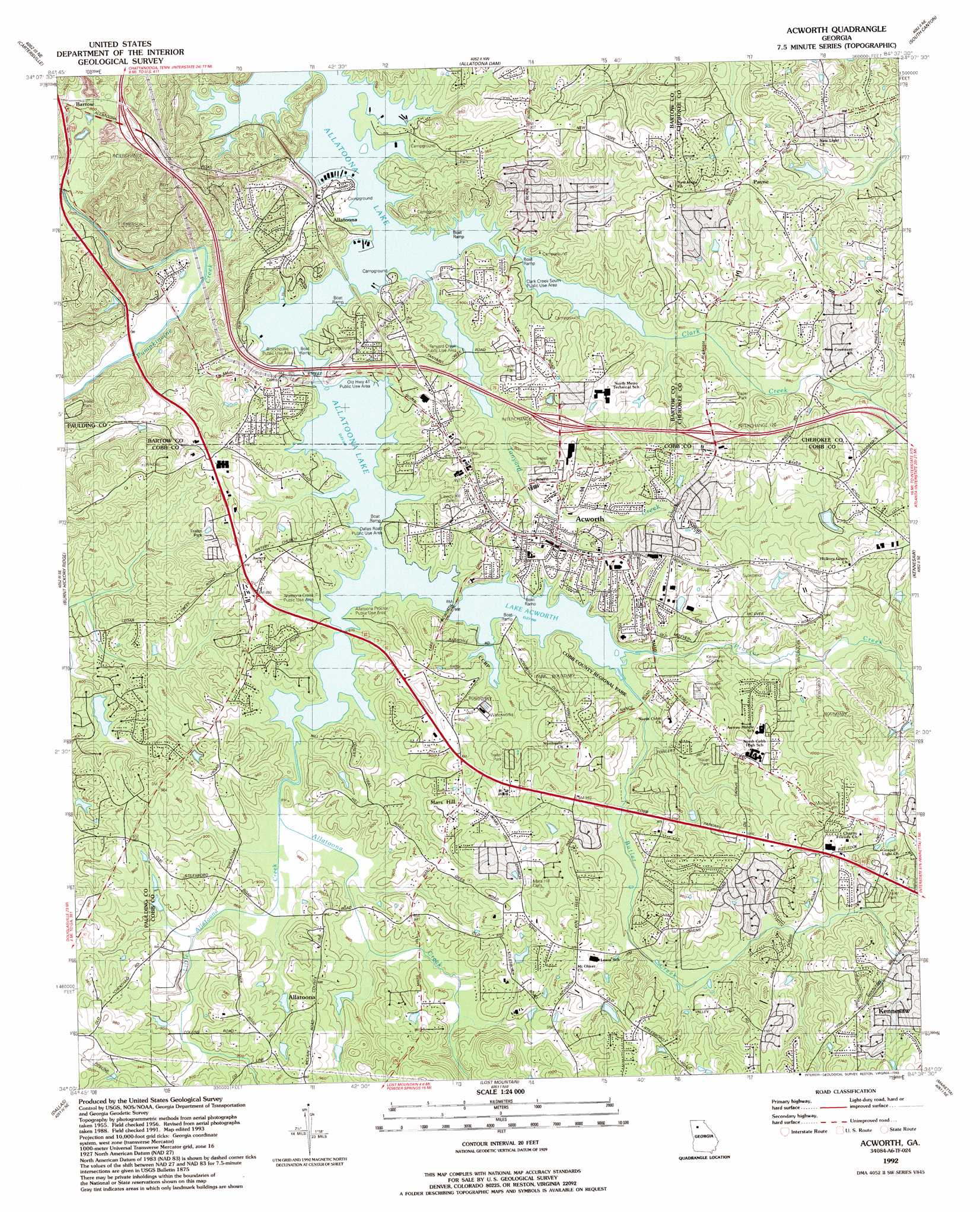
USGS Topo Quad 34084a6 - 1:24,000 scale
| Topo Map Name: | Acworth |
| USGS Topo Quad ID: | 34084a6 |
| Print Size: | ca. 21 1/4" wide x 27" high |
| Southeast Coordinates: | 34° N latitude / 84.625° W longitude |
| Map Center Coordinates: | 34.0625° N latitude / 84.6875° W longitude |
| U.S. State: | GA |
| Filename: | o34084a6.jpg |
| Download Map JPG Image: | Acworth topo map 1:24,000 scale |
| Map Type: | Topographic |
| Topo Series: | 7.5´ |
| Map Scale: | 1:24,000 |
| Source of Map Images: | United States Geological Survey (USGS) |
| Alternate Map Versions: |
Acworth GA 1956, updated 1957 Download PDF Buy paper map Acworth GA 1956, updated 1969 Download PDF Buy paper map Acworth GA 1956, updated 1974 Download PDF Buy paper map Acworth GA 1956, updated 1986 Download PDF Buy paper map Acworth GA 1992, updated 1993 Download PDF Buy paper map Acworth GA 2011 Download PDF Buy paper map Acworth GA 2014 Download PDF Buy paper map |
1:24,000 Topo Quads surrounding Acworth
Adairsville |
White West |
White East |
Waleska |
Ball Ground West |
Kingston |
Cartersville |
Allatoona Dam |
South Canton |
Canton |
Tayorsville |
Burnt Hickory Ridge |
Acworth |
Kennesaw |
Mountain Park |
Yorkville |
Dallas |
Lost Mountain |
Marietta |
Sandy Springs |
New Georgia |
Nebo |
Austell |
Mableton |
Northwest Atlanta |
> Back to 34084a1 at 1:100,000 scale
> Back to 34084a1 at 1:250,000 scale
> Back to U.S. Topo Maps home
Acworth topo map: Gazetteer
Acworth: Airports
Georgia Lite Flite Airport elevation 283m 928′Acworth: Beaches
Upper Tanyard Creek Swimming Beach elevation 256m 839′Acworth: Crossings
Interchange 120 elevation 292m 958′Interchange 121 elevation 274m 898′
Interchange 122 elevation 237m 777′
Acworth: Dams
Bobe Lake Dam elevation 275m 902′Kellner Lake Dam elevation 302m 990′
Whites Lake Dam elevation 297m 974′
Acworth: Lakes
Lake Acworth elevation 258m 846′Acworth: Mines
Glade Mine elevation 298m 977′Acworth: Parks
Clark Creek South Public Use Area elevation 258m 846′Coats and Clark Park elevation 280m 918′
Cobb County Regional Park elevation 258m 846′
Kenworth Park elevation 263m 862′
Old Highway 41 Recreation Area elevation 267m 875′
Acworth: Populated Places
Acworth elevation 277m 908′Acworth Beach elevation 266m 872′
Acworth Meadows elevation 283m 928′
Allatoona elevation 269m 882′
Allatoona Bay elevation 273m 895′
Allatoona Beach elevation 264m 866′
Allatoona Heights elevation 263m 862′
Allatoona Quarters elevation 277m 908′
Allatoona Ridge elevation 267m 875′
Allatoona Shores elevation 276m 905′
Baker Ridge elevation 322m 1056′
Bartow elevation 261m 856′
Big Shanty Hills elevation 341m 1118′
Blue Springs elevation 292m 958′
Blue Springs Village Mobile Home Park elevation 293m 961′
Brookwood elevation 276m 905′
Calumet Woods elevation 286m 938′
Cedar Crest Plantation elevation 236m 774′
Cedar Mill Crossing elevation 296m 971′
Country Creek elevation 302m 990′
Countryside Estates elevation 293m 961′
Davenport Trace elevation 287m 941′
Edgewood Estates elevation 282m 925′
Emerald Forest elevation 286m 938′
Emerald Willows elevation 268m 879′
Etheridge Glen elevation 300m 984′
Etowah Cove elevation 277m 908′
Etowah Mills elevation 281m 921′
Falcon Shores elevation 279m 915′
Green Hills Estates elevation 289m 948′
Greyfield North elevation 324m 1062′
Harris Woods elevation 298m 977′
Hill Forest Estates elevation 285m 935′
Hills-A-Rolling elevation 288m 944′
Homestead Acres elevation 275m 902′
Hunt Club elevation 304m 997′
Hunters Cove elevation 270m 885′
Indian Village elevation 292m 958′
Iron Hill elevation 275m 902′
Jarratt Crossing elevation 274m 898′
Kennesaw Acres elevation 310m 1017′
Lake Manor elevation 277m 908′
Lakeview Heights elevation 275m 902′
Lakewood Heights elevation 270m 885′
Laurel Hills elevation 285m 935′
Logan Meadow elevation 283m 928′
Logan Trace elevation 280m 918′
Mars Hill elevation 288m 944′
Mars Hill Acres elevation 284m 931′
Mars Hill Downs elevation 280m 918′
McCollum Acres elevation 290m 951′
McGuire Heights elevation 291m 954′
Mitchell Hill elevation 286m 938′
Modern Living Mobile Home Park elevation 278m 912′
North Bend elevation 285m 935′
North Shores elevation 276m 905′
Northwind elevation 294m 964′
Nowlin Woods elevation 293m 961′
Old Cedar Creek elevation 287m 941′
Owens Meadows elevation 319m 1046′
Pages Mobile Home Park elevation 280m 918′
Payne elevation 299m 980′
Payne Mobile Home Park elevation 298m 977′
Picketts Crossing elevation 280m 918′
Picketts Mill elevation 294m 964′
Picketts Plantation elevation 288m 944′
Pinehurst elevation 287m 941′
Plantation Walk elevation 281m 921′
Salem Woods elevation 305m 1000′
Sequoyah Estates elevation 289m 948′
Shiloh West elevation 305m 1000′
Signal Point elevation 336m 1102′
Stilesboro Hills elevation 323m 1059′
Summer Trace elevation 276m 905′
Twin Pines elevation 288m 944′
Valley Hill Estates elevation 303m 994′
Vestavia Estates elevation 289m 948′
Westwood Station elevation 288m 944′
Whites Lake elevation 300m 984′
Whitney Station elevation 287m 941′
Yacht Club Estates elevation 290m 951′
Acworth: Post Offices
Acworth Post Office elevation 277m 908′Acworth: Reservoirs
Bobe Lake elevation 275m 902′Kellner Lake elevation 302m 990′
Whites Lake elevation 297m 974′
Acworth: Streams
Butler Creek elevation 259m 849′Clark Creek elevation 258m 846′
Little Allatoona Creek elevation 258m 846′
Proctor Creek elevation 258m 846′
Tanyard Creek elevation 263m 862′
Acworth digital topo map on disk
Buy this Acworth topo map showing relief, roads, GPS coordinates and other geographical features, as a high-resolution digital map file on DVD: