Tayorsville Topo Map Georgia
To zoom in, hover over the map of Tayorsville
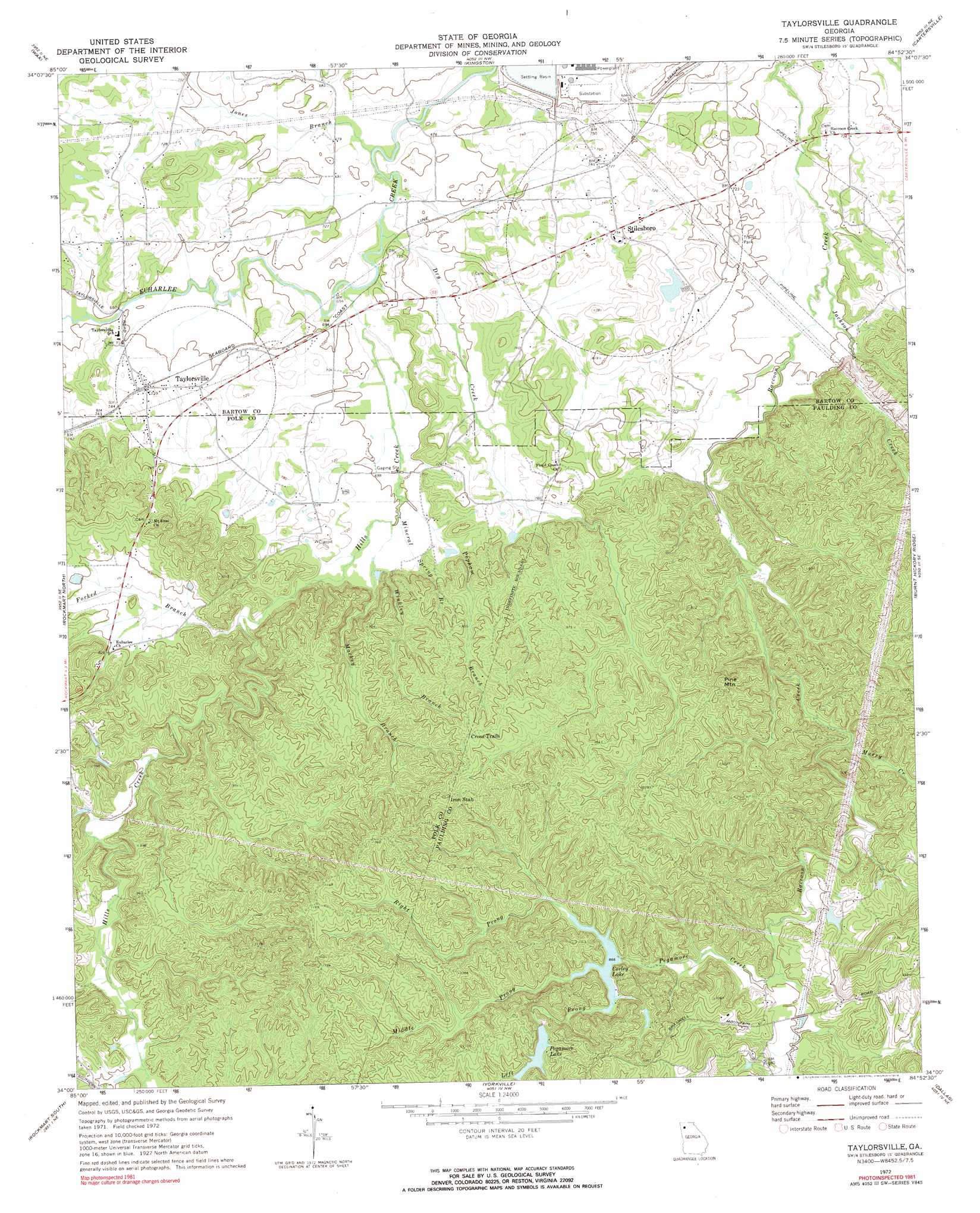
USGS Topo Quad 34084a8 - 1:24,000 scale
| Topo Map Name: | Tayorsville |
| USGS Topo Quad ID: | 34084a8 |
| Print Size: | ca. 21 1/4" wide x 27" high |
| Southeast Coordinates: | 34° N latitude / 84.875° W longitude |
| Map Center Coordinates: | 34.0625° N latitude / 84.9375° W longitude |
| U.S. State: | GA |
| Filename: | o34084a8.jpg |
| Download Map JPG Image: | Tayorsville topo map 1:24,000 scale |
| Map Type: | Topographic |
| Topo Series: | 7.5´ |
| Map Scale: | 1:24,000 |
| Source of Map Images: | United States Geological Survey (USGS) |
| Alternate Map Versions: |
Taylorsville GA 1972, updated 1974 Download PDF Buy paper map Taylorsville GA 2011 Download PDF Buy paper map Taylorsville GA 2014 Download PDF Buy paper map |
1:24,000 Topo Quads surrounding Tayorsville
Rome North |
Shannon |
Adairsville |
White West |
White East |
Rome South |
Wax |
Kingston |
Cartersville |
Allatoona Dam |
Cedartown East |
Rockmart North |
Tayorsville |
Burnt Hickory Ridge |
Acworth |
Felton |
Rockmart South |
Yorkville |
Dallas |
Lost Mountain |
Buchanan |
Draketown |
New Georgia |
Nebo |
Austell |
> Back to 34084a1 at 1:100,000 scale
> Back to 34084a1 at 1:250,000 scale
> Back to U.S. Topo Maps home
Tayorsville topo map: Gazetteer
Tayorsville: Dams
Corley Lake Dam elevation 263m 862′Pegamore Lake Dam elevation 282m 925′
Tayorsville: Populated Places
Braswell Corners elevation 293m 961′Don (historical) elevation 280m 918′
Iron Stab elevation 330m 1082′
McGinnis (historical) elevation 207m 679′
Stilesboro elevation 225m 738′
Taylorsville elevation 223m 731′
Tayorsville: Reservoirs
Corley Lake elevation 263m 862′Pegamore Lake elevation 282m 925′
Tayorsville: Streams
Dry Creek elevation 207m 679′Forked Branch elevation 224m 734′
Hills Creek elevation 207m 679′
Jackson Creek elevation 207m 679′
Jones Branch elevation 201m 659′
Left Prong Pegamore Creek elevation 266m 872′
Mackey Branch elevation 214m 702′
Middle Prong Pegamore Creek elevation 264m 866′
Mineral Spring Branch elevation 214m 702′
Murry Creek elevation 225m 738′
Pegamore Creek elevation 242m 793′
Popham Branch elevation 213m 698′
Right Prong Pegamore Creek elevation 268m 879′
Winkley Branch elevation 214m 702′
Tayorsville: Summits
Pine Mountain elevation 323m 1059′Tayorsville digital topo map on disk
Buy this Tayorsville topo map showing relief, roads, GPS coordinates and other geographical features, as a high-resolution digital map file on DVD: