Buford Dam Topo Map Georgia
To zoom in, hover over the map of Buford Dam
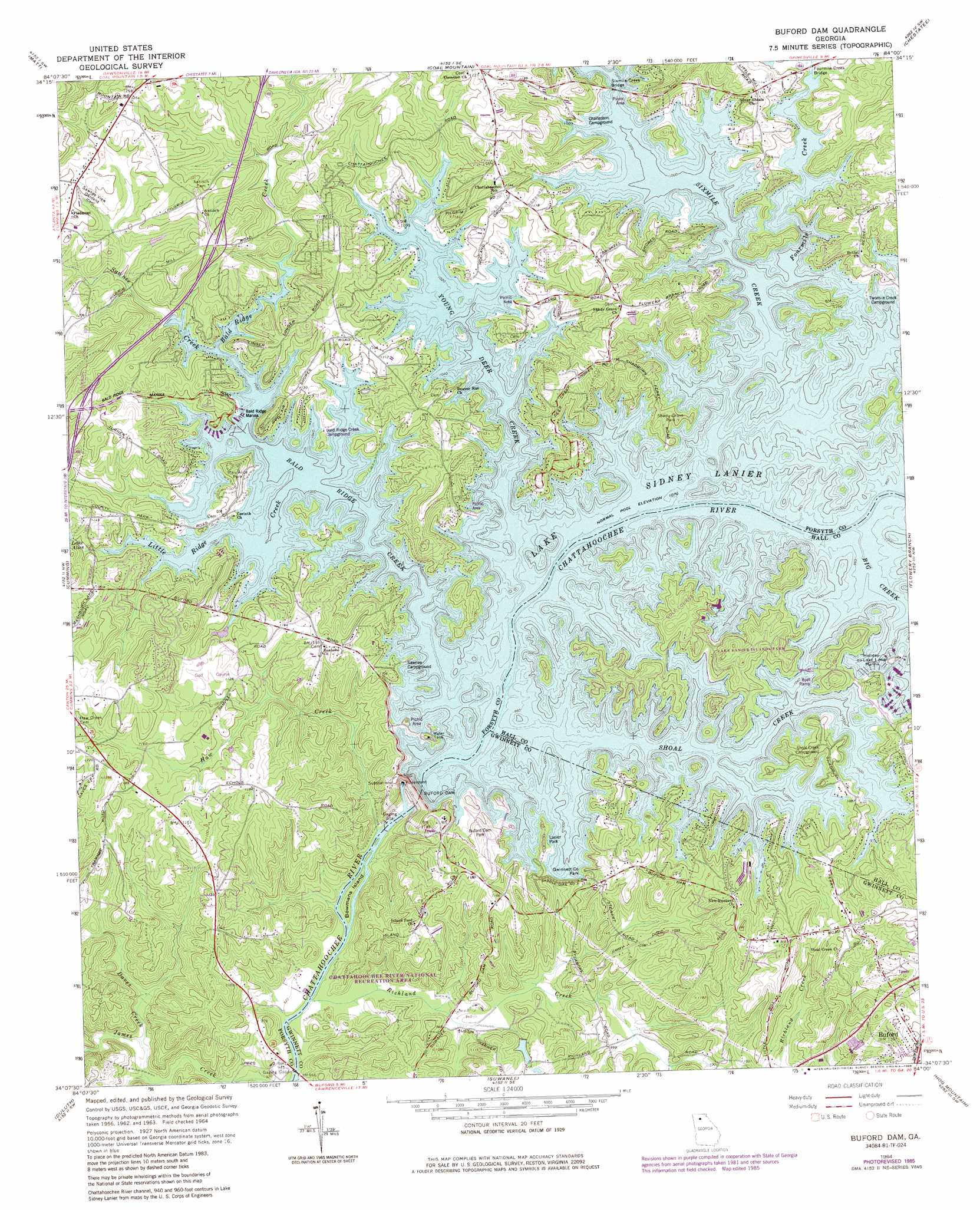
USGS Topo Quad 34084b1 - 1:24,000 scale
| Topo Map Name: | Buford Dam |
| USGS Topo Quad ID: | 34084b1 |
| Print Size: | ca. 21 1/4" wide x 27" high |
| Southeast Coordinates: | 34.125° N latitude / 84° W longitude |
| Map Center Coordinates: | 34.1875° N latitude / 84.0625° W longitude |
| U.S. State: | GA |
| Filename: | o34084b1.jpg |
| Download Map JPG Image: | Buford Dam topo map 1:24,000 scale |
| Map Type: | Topographic |
| Topo Series: | 7.5´ |
| Map Scale: | 1:24,000 |
| Source of Map Images: | United States Geological Survey (USGS) |
| Alternate Map Versions: |
Buford Dam GA 1964, updated 1965 Download PDF Buy paper map Buford Dam GA 1964, updated 1971 Download PDF Buy paper map Buford Dam GA 1964, updated 1974 Download PDF Buy paper map Buford Dam GA 1964, updated 1986 Download PDF Buy paper map Buford Dam GA 1993, updated 2000 Download PDF Buy paper map Buford Dam GA 1999, updated 2003 Download PDF Buy paper map Buford Dam GA 2011 Download PDF Buy paper map Buford Dam GA 2014 Download PDF Buy paper map |
1:24,000 Topo Quads surrounding Buford Dam
Nelson |
Juno |
Dawsonville |
Murrayville |
Clermont |
Ball Ground East |
Matt |
Coal Mountain |
Chestatee |
Gainesville |
Birmingham |
Cumming |
Buford Dam |
Flowery Branch |
Chestnut Mountain |
Roswell |
Duluth |
Suwanee |
Hog Mountain |
Auburn |
Chamblee |
Norcross |
Luxomni |
Lawrenceville |
Bold Springs |
> Back to 34084a1 at 1:100,000 scale
> Back to 34084a1 at 1:250,000 scale
> Back to U.S. Topo Maps home
Buford Dam topo map: Gazetteer
Buford Dam: Airports
Ebeneezer Airport elevation 368m 1207′McDonald Heliport elevation 336m 1102′
Stouffer Pine Isle Resort Heliport elevation 331m 1085′
Buford Dam: Bars
Bowmans Island Shoals elevation 279m 915′Buford Dam: Bridges
Fourmile Creek Bridge elevation 329m 1079′Sixmile Creek Bridge elevation 326m 1069′
Buford Dam: Crossings
Orrs Ferry (historical) elevation 278m 912′Shadburn Ferry (historical) elevation 326m 1069′
Buford Dam: Dams
Buford Dam elevation 328m 1076′Mashburn Mill Dam elevation 339m 1112′
Buford Dam: Islands
Bowmans Island elevation 281m 921′Buford Dam: Parks
Bald Ridge Creek Public Use Area elevation 329m 1079′Buford Park elevation 336m 1102′
Central Park elevation 369m 1210′
Chattahoochee River National Recreation Area elevation 324m 1062′
Gwinnett County Park elevation 336m 1102′
Lake Lanier Islands Park elevation 355m 1164′
Little Shoal Creek Public Use Area elevation 338m 1108′
Mary Alice Park elevation 351m 1151′
Shady Grove Park elevation 346m 1135′
Tri-County Park elevation 352m 1154′
West Bank Public Use Area elevation 332m 1089′
Buford Dam: Populated Places
Lake Forest elevation 342m 1122′Lake Lanier Vista elevation 350m 1148′
Northwest Harbor elevation 346m 1135′
Buford Dam: Reservoirs
Lake Alice elevation 341m 1118′Lake Sidney Lanier elevation 328m 1076′
Mashburn Mill Lake elevation 339m 1112′
Buford Dam: Streams
Baldridge Creek elevation 326m 1069′Daves Creek elevation 286m 938′
Fourmile Creek elevation 326m 1069′
Haw Creek elevation 279m 915′
Little Ridge Creek elevation 326m 1069′
Richland Creek elevation 281m 921′
Sawnee Creek elevation 326m 1069′
Shoal Creek elevation 326m 1069′
Sixmile Creek elevation 326m 1069′
Young Deer Creek elevation 326m 1069′
Buford Dam digital topo map on disk
Buy this Buford Dam topo map showing relief, roads, GPS coordinates and other geographical features, as a high-resolution digital map file on DVD: