Cumming Topo Map Georgia
To zoom in, hover over the map of Cumming
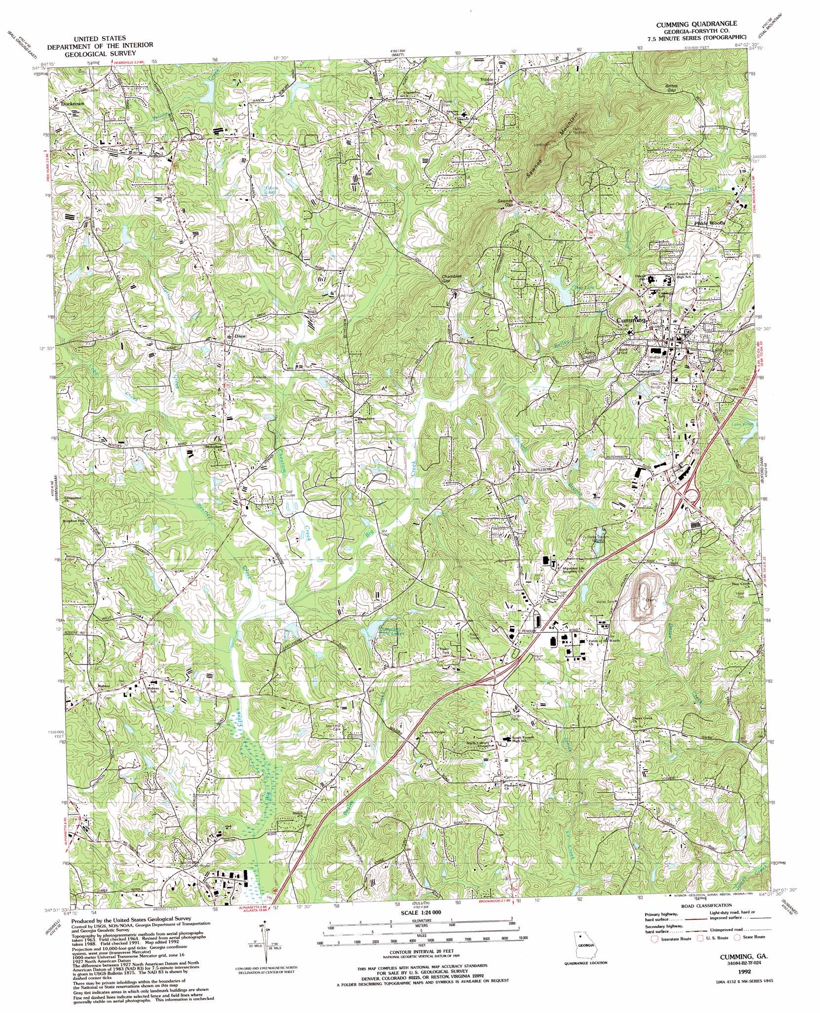
USGS Topo Quad 34084b2 - 1:24,000 scale
| Topo Map Name: | Cumming |
| USGS Topo Quad ID: | 34084b2 |
| Print Size: | ca. 21 1/4" wide x 27" high |
| Southeast Coordinates: | 34.125° N latitude / 84.125° W longitude |
| Map Center Coordinates: | 34.1875° N latitude / 84.1875° W longitude |
| U.S. State: | GA |
| Filename: | o34084b2.jpg |
| Download Map JPG Image: | Cumming topo map 1:24,000 scale |
| Map Type: | Topographic |
| Topo Series: | 7.5´ |
| Map Scale: | 1:24,000 |
| Source of Map Images: | United States Geological Survey (USGS) |
| Alternate Map Versions: |
Cumming GA 1964, updated 1965 Download PDF Buy paper map Cumming GA 1964, updated 1973 Download PDF Buy paper map Cumming GA 1964, updated 1974 Download PDF Buy paper map Cumming GA 1964, updated 1986 Download PDF Buy paper map Cumming GA 1992, updated 1993 Download PDF Buy paper map Cumming GA 1999, updated 2003 Download PDF Buy paper map Cumming GA 2011 Download PDF Buy paper map Cumming GA 2014 Download PDF Buy paper map |
1:24,000 Topo Quads surrounding Cumming
Jasper |
Nelson |
Juno |
Dawsonville |
Murrayville |
Ball Ground West |
Ball Ground East |
Matt |
Coal Mountain |
Chestatee |
Canton |
Birmingham |
Cumming |
Buford Dam |
Flowery Branch |
Mountain Park |
Roswell |
Duluth |
Suwanee |
Hog Mountain |
Sandy Springs |
Chamblee |
Norcross |
Luxomni |
Lawrenceville |
> Back to 34084a1 at 1:100,000 scale
> Back to 34084a1 at 1:250,000 scale
> Back to U.S. Topo Maps home
Cumming topo map: Gazetteer
Cumming: Airports
Downing Airport elevation 349m 1145′Cumming: Dams
Cumming Twin Lake Number One Dam elevation 333m 1092′Cumming Twin Lake Number Two Dam elevation 333m 1092′
Johnsen Dam elevation 352m 1154′
Mcwilliams Lake Dam elevation 339m 1112′
Pine Lake Dam elevation 340m 1115′
Sawnee Lake Dam elevation 311m 1020′
Settingdown Creek Structure 30-A Dam elevation 347m 1138′
Settingdown Creek Structure 30-B Dam elevation 341m 1118′
Wilkie Dam elevation 355m 1164′
Cumming: Gaps
Bettes Gap elevation 411m 1348′Chamblee Gap elevation 395m 1295′
Sawnee Gap elevation 405m 1328′
Tribble Gap elevation 371m 1217′
Cumming: Lakes
Pine Lake elevation 347m 1138′Cumming: Parks
Cumming City Park elevation 380m 1246′Midway Park elevation 338m 1108′
Cumming: Populated Places
Cumming elevation 371m 1217′Drew elevation 350m 1148′
Ducktown elevation 383m 1256′
Dunn elevation 372m 1220′
Mars Hill Crossroads elevation 347m 1138′
Pirkle Woods elevation 370m 1213′
The Polo Fields elevation 331m 1085′
Cumming: Post Offices
Cumming Post Office elevation 369m 1210′Cumming: Reservoirs
Cumming Twin Lake Number One elevation 333m 1092′Cumming Twin Lake Number Two elevation 333m 1092′
Cumming Twin Lakes elevation 333m 1092′
Johnsen Lake elevation 352m 1154′
Mcwilliams Lake elevation 339m 1112′
Odum Lake elevation 341m 1118′
Pine Lake elevation 340m 1115′
Reservoir 30-A elevation 347m 1138′
Reservoir 30-B elevation 341m 1118′
Sawnee Lake elevation 311m 1020′
Wilkie elevation 355m 1164′
Cumming: Streams
Bentley Creek elevation 310m 1017′Cheatam Creek elevation 311m 1020′
Cobb Creek elevation 317m 1040′
Harris Creek elevation 317m 1040′
Kelley Mill Branch elevation 326m 1069′
Sawmill Branch elevation 322m 1056′
Cumming: Summits
Sawnee Mountain elevation 592m 1942′Cumming: Trails
Brookshire Creek Trail elevation 378m 1240′Cumming digital topo map on disk
Buy this Cumming topo map showing relief, roads, GPS coordinates and other geographical features, as a high-resolution digital map file on DVD: