Canton Topo Map Georgia
To zoom in, hover over the map of Canton
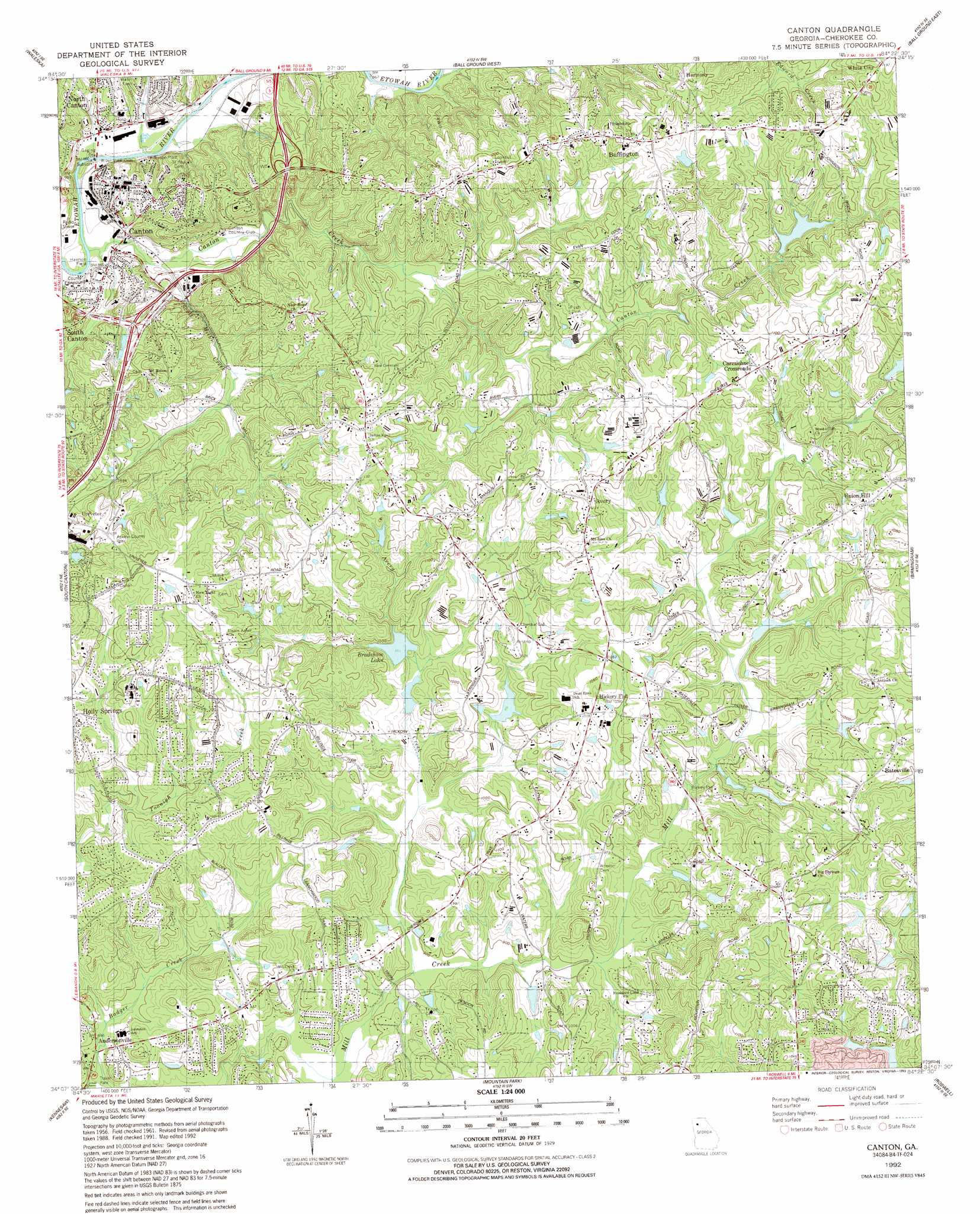
USGS Topo Quad 34084b4 - 1:24,000 scale
| Topo Map Name: | Canton |
| USGS Topo Quad ID: | 34084b4 |
| Print Size: | ca. 21 1/4" wide x 27" high |
| Southeast Coordinates: | 34.125° N latitude / 84.375° W longitude |
| Map Center Coordinates: | 34.1875° N latitude / 84.4375° W longitude |
| U.S. State: | GA |
| Filename: | o34084b4.jpg |
| Download Map JPG Image: | Canton topo map 1:24,000 scale |
| Map Type: | Topographic |
| Topo Series: | 7.5´ |
| Map Scale: | 1:24,000 |
| Source of Map Images: | United States Geological Survey (USGS) |
| Alternate Map Versions: |
Canton GA 1961, updated 1963 Download PDF Buy paper map Canton GA 1961, updated 1969 Download PDF Buy paper map Canton GA 1961, updated 1986 Download PDF Buy paper map Canton GA 1992, updated 1993 Download PDF Buy paper map Canton GA 2011 Download PDF Buy paper map Canton GA 2014 Download PDF Buy paper map |
1:24,000 Topo Quads surrounding Canton
Fairmount |
Ludville |
Jasper |
Nelson |
Juno |
White East |
Waleska |
Ball Ground West |
Ball Ground East |
Matt |
Allatoona Dam |
South Canton |
Canton |
Birmingham |
Cumming |
Acworth |
Kennesaw |
Mountain Park |
Roswell |
Duluth |
Lost Mountain |
Marietta |
Sandy Springs |
Chamblee |
Norcross |
> Back to 34084a1 at 1:100,000 scale
> Back to 34084a1 at 1:250,000 scale
> Back to U.S. Topo Maps home
Canton topo map: Gazetteer
Canton: Airports
Stringer Airport elevation 311m 1020′Canton: Dams
Blalock Lake Dam elevation 286m 938′Bradshaw Lake Dam elevation 289m 948′
Carmichael Lake Dam elevation 318m 1043′
Cherokee Estates Lake Dam elevation 290m 951′
Lacy Lake Dam elevation 319m 1046′
Mill Canton Creek Structure Number 10 Dam elevation 288m 944′
Mill Canton Creek Structure Number 12 Dam elevation 290m 951′
Mill Canton Creek Structure Number Four Dam elevation 321m 1053′
Mill Canton Creek Structure Number Seven Dam elevation 324m 1062′
Mill Canton Creek Structure Number Six Dam elevation 280m 918′
Sellers Lake Dam elevation 295m 967′
Waters Lake Dam elevation 274m 898′
Canton: Parks
Brown Park elevation 291m 954′Canton Commerical Historic District elevation 295m 967′
Harmon Field elevation 265m 869′
Kenney Askew County Park elevation 341m 1118′
Canton: Populated Places
Andersonville elevation 264m 866′Avery elevation 342m 1122′
Batesville elevation 318m 1043′
Buffington elevation 367m 1204′
Canton elevation 295m 967′
Carmichael Crossroads elevation 331m 1085′
Harmony elevation 379m 1243′
Hickory Flat elevation 317m 1040′
North Canton elevation 272m 892′
Union Hill elevation 325m 1066′
White City elevation 366m 1200′
Canton: Post Offices
Canton Post Office elevation 295m 967′Canton: Reservoirs
Blalock Lake elevation 286m 938′Bradshaw Lake elevation 289m 948′
Cagle Lake elevation 290m 951′
Carmichael Lake elevation 318m 1043′
Garrison Lake elevation 324m 1062′
Great Southeastern Land Fund Lake elevation 311m 1020′
Hurte Lake elevation 321m 1053′
Lacy Lake elevation 319m 1046′
Lusk Lake elevation 288m 944′
Sellers Lake elevation 295m 967′
Waters Lake elevation 274m 898′
Canton: Streams
Avery Creek elevation 271m 889′Canton Creek elevation 262m 859′
Scott Mill Creek elevation 262m 859′
Canton digital topo map on disk
Buy this Canton topo map showing relief, roads, GPS coordinates and other geographical features, as a high-resolution digital map file on DVD: