Cartersville Topo Map Georgia
To zoom in, hover over the map of Cartersville
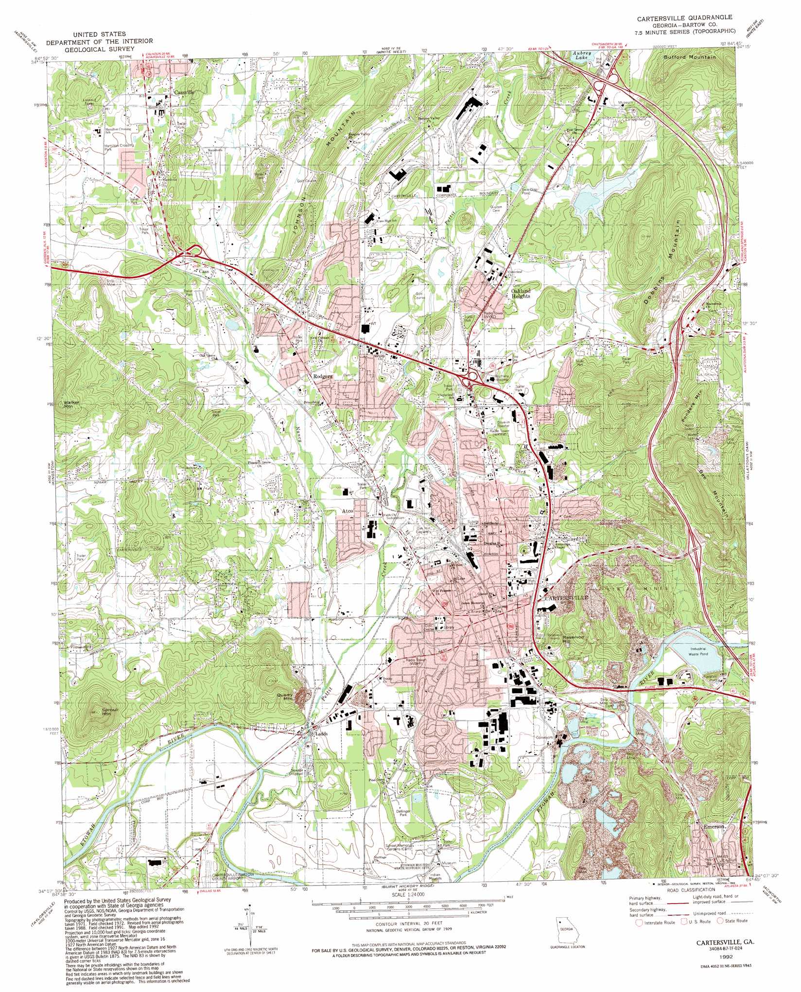
USGS Topo Quad 34084b7 - 1:24,000 scale
| Topo Map Name: | Cartersville |
| USGS Topo Quad ID: | 34084b7 |
| Print Size: | ca. 21 1/4" wide x 27" high |
| Southeast Coordinates: | 34.125° N latitude / 84.75° W longitude |
| Map Center Coordinates: | 34.1875° N latitude / 84.8125° W longitude |
| U.S. State: | GA |
| Filename: | o34084b7.jpg |
| Download Map JPG Image: | Cartersville topo map 1:24,000 scale |
| Map Type: | Topographic |
| Topo Series: | 7.5´ |
| Map Scale: | 1:24,000 |
| Source of Map Images: | United States Geological Survey (USGS) |
| Alternate Map Versions: |
Cartersville GA 1972, updated 1974 Download PDF Buy paper map Cartersville GA 1972, updated 1986 Download PDF Buy paper map Cartersville GA 1992, updated 1993 Download PDF Buy paper map Cartersville GA 2011 Download PDF Buy paper map Cartersville GA 2014 Download PDF Buy paper map |
1:24,000 Topo Quads surrounding Cartersville
Plainville |
Calhoun South |
Sonoraville |
Fairmount |
Ludville |
Shannon |
Adairsville |
White West |
White East |
Waleska |
Wax |
Kingston |
Cartersville |
Allatoona Dam |
South Canton |
Rockmart North |
Tayorsville |
Burnt Hickory Ridge |
Acworth |
Kennesaw |
Rockmart South |
Yorkville |
Dallas |
Lost Mountain |
Marietta |
> Back to 34084a1 at 1:100,000 scale
> Back to 34084a1 at 1:250,000 scale
> Back to U.S. Topo Maps home
Cartersville topo map: Gazetteer
Cartersville: Dams
Aubrey Lake Dam elevation 239m 784′Gene Tilley Lake Dam elevation 350m 1148′
Cartersville: Parks
Dellinger Park elevation 213m 698′Cartersville: Populated Places
Atco elevation 221m 725′Belaire elevation 260m 853′
Browns (historical) elevation 202m 662′
Buena Vista elevation 257m 843′
Burnt Hickory Hills elevation 243m 797′
Cartersville elevation 234m 767′
Cassville elevation 253m 830′
Conyers Estates elevation 245m 803′
Country Village elevation 246m 807′
County Manor elevation 245m 803′
Deerfield Estates elevation 213m 698′
Emerson elevation 254m 833′
Greenbriar elevation 227m 744′
Habersham elevation 237m 777′
Harvest Estates elevation 245m 803′
Hidden Hills elevation 320m 1049′
Interchange Village elevation 248m 813′
Jones Heights elevation 240m 787′
Junta elevation 226m 741′
Ladds elevation 210m 688′
Mission Estates elevation 250m 820′
Mission Hills elevation 239m 784′
North Highland elevation 227m 744′
Oakland Heights elevation 242m 793′
Rodgers elevation 225m 738′
Roving Hills Estates elevation 249m 816′
Shallwood elevation 233m 764′
Terrell Heights elevation 222m 728′
Walker Hills elevation 250m 820′
Wayfare Estates elevation 254m 833′
Wildwood elevation 262m 859′
Cartersville: Post Offices
Atco Post Office (historical) elevation 219m 718′Cartersville Post Office elevation 236m 774′
Cassville Post Office elevation 244m 800′
Emerson Post Office elevation 255m 836′
Cartersville: Reservoirs
Aubrey Lake elevation 239m 784′Gene Tilley Lake elevation 350m 1148′
Cartersville: Streams
Nancy Creek elevation 207m 679′Pettit Creek elevation 201m 659′
Ryle Creek elevation 201m 659′
Satterfield Branch elevation 218m 715′
Cartersville: Summits
Bee Mountain elevation 413m 1354′Bufford Mountain elevation 404m 1325′
Dobbins Mountain elevation 332m 1089′
Johnson Mountain elevation 283m 928′
Ponders Mountain elevation 387m 1269′
Quarry Mountain elevation 308m 1010′
Reservoir Hill elevation 295m 967′
Sproull Mountain elevation 360m 1181′
Walker Mountain elevation 332m 1089′
Cartersville: Valleys
Peeples Valley elevation 220m 721′Cartersville digital topo map on disk
Buy this Cartersville topo map showing relief, roads, GPS coordinates and other geographical features, as a high-resolution digital map file on DVD: