Matt Topo Map Georgia
To zoom in, hover over the map of Matt
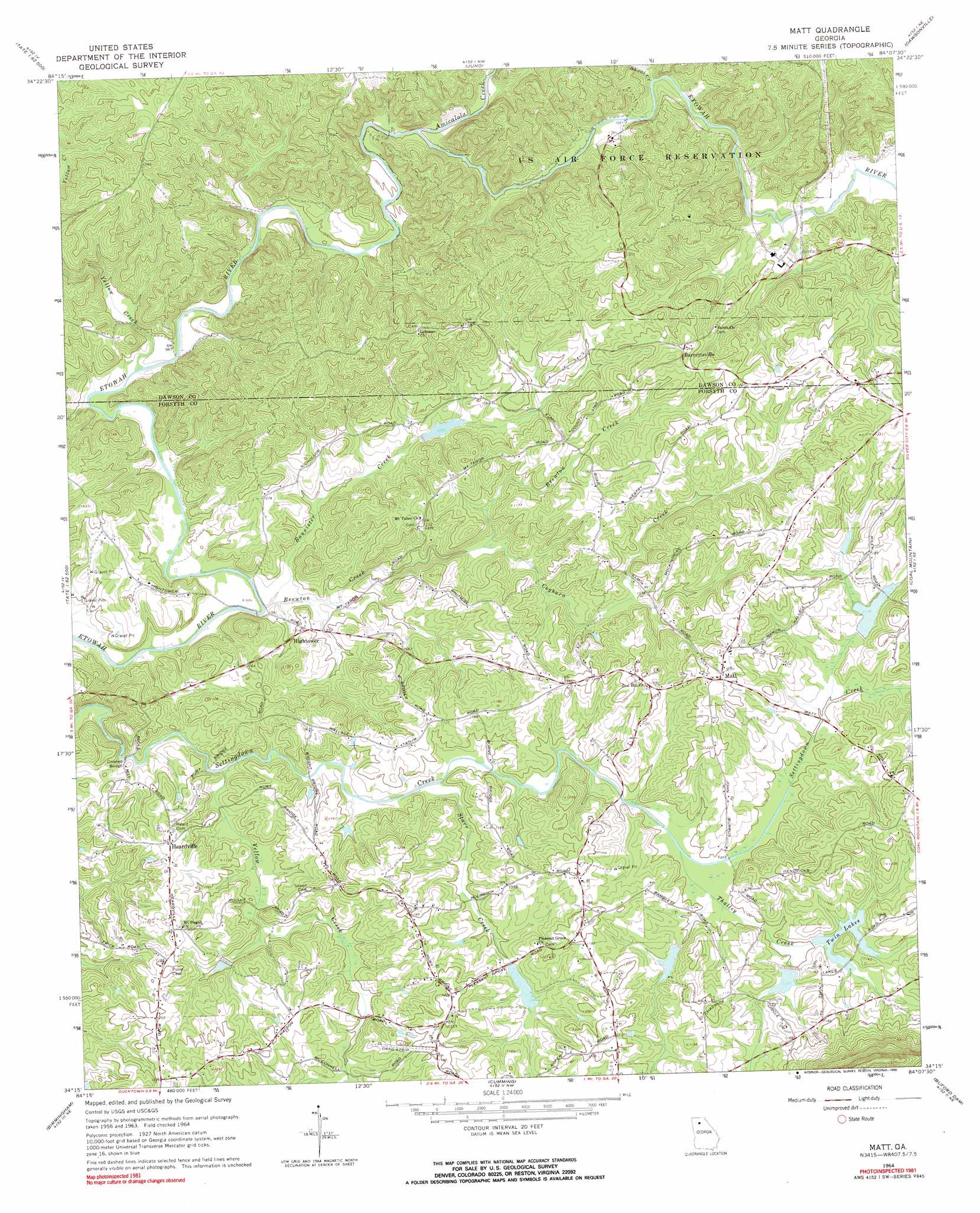
USGS Topo Quad 34084c2 - 1:24,000 scale
| Topo Map Name: | Matt |
| USGS Topo Quad ID: | 34084c2 |
| Print Size: | ca. 21 1/4" wide x 27" high |
| Southeast Coordinates: | 34.25° N latitude / 84.125° W longitude |
| Map Center Coordinates: | 34.3125° N latitude / 84.1875° W longitude |
| U.S. State: | GA |
| Filename: | o34084c2.jpg |
| Download Map JPG Image: | Matt topo map 1:24,000 scale |
| Map Type: | Topographic |
| Topo Series: | 7.5´ |
| Map Scale: | 1:24,000 |
| Source of Map Images: | United States Geological Survey (USGS) |
| Alternate Map Versions: |
Matt GA 1964, updated 1965 Download PDF Buy paper map Matt GA 1964, updated 1974 Download PDF Buy paper map Matt GA 1964, updated 1984 Download PDF Buy paper map Matt GA 1964, updated 1990 Download PDF Buy paper map Matt GA 1999, updated 2003 Download PDF Buy paper map Matt GA 2011 Download PDF Buy paper map Matt GA 2014 Download PDF Buy paper map |
1:24,000 Topo Quads surrounding Matt
Dyke |
Amicalola |
Nimblewill |
Campbell Mountain |
Dahlonega |
Jasper |
Nelson |
Juno |
Dawsonville |
Murrayville |
Ball Ground West |
Ball Ground East |
Matt |
Coal Mountain |
Chestatee |
Canton |
Birmingham |
Cumming |
Buford Dam |
Flowery Branch |
Mountain Park |
Roswell |
Duluth |
Suwanee |
Hog Mountain |
> Back to 34084a1 at 1:100,000 scale
> Back to 34084a1 at 1:250,000 scale
> Back to U.S. Topo Maps home
Matt topo map: Gazetteer
Matt: Bridges
Pooles Mill Covered Bridge elevation 312m 1023′Matt: Dams
Etowah River Structure Number Four Dam elevation 338m 1108′Etowah River Subwatershed Number One Dam elevation 307m 1007′
Settingdown Creek Structure 11 Dam elevation 343m 1125′
Settingdown Creek Structure 15 Dam elevation 339m 1112′
Settingdown Creek Structure 16 Dam elevation 339m 1112′
Settingdown Creek Structure 21 Dam elevation 340m 1115′
Settingdown Creek Structure 26 Dam elevation 336m 1102′
Matt: Populated Places
Barrettsville elevation 379m 1243′Heardville elevation 351m 1151′
Hightower elevation 308m 1010′
Hubbardsville elevation 394m 1292′
Matt elevation 371m 1217′
Matt: Reservoirs
Reservoir 15 elevation 339m 1112′Reservoir 21 elevation 340m 1115′
Reservoir 26 elevation 336m 1102′
Reservoir Four elevation 338m 1108′
Reservoir Number One elevation 307m 1007′
Settingdown Creek Reservoir Number Two elevation 341m 1118′
Twin Lakes elevation 339m 1112′
Matt: Streams
Amicalola Creek elevation 305m 1000′Bannister Creek elevation 293m 961′
Brewton Creek elevation 293m 961′
Cogburn Creek elevation 307m 1007′
Shoal Creek elevation 310m 1017′
Squattingdown Creek elevation 340m 1115′
Starr Creek elevation 323m 1059′
Thalley Creek elevation 334m 1095′
Yellow Creek elevation 298m 977′
Yellow Creek elevation 316m 1036′
Matt: Valleys
Big Savannah elevation 311m 1020′Matt digital topo map on disk
Buy this Matt topo map showing relief, roads, GPS coordinates and other geographical features, as a high-resolution digital map file on DVD: