Nelson Topo Map Georgia
To zoom in, hover over the map of Nelson
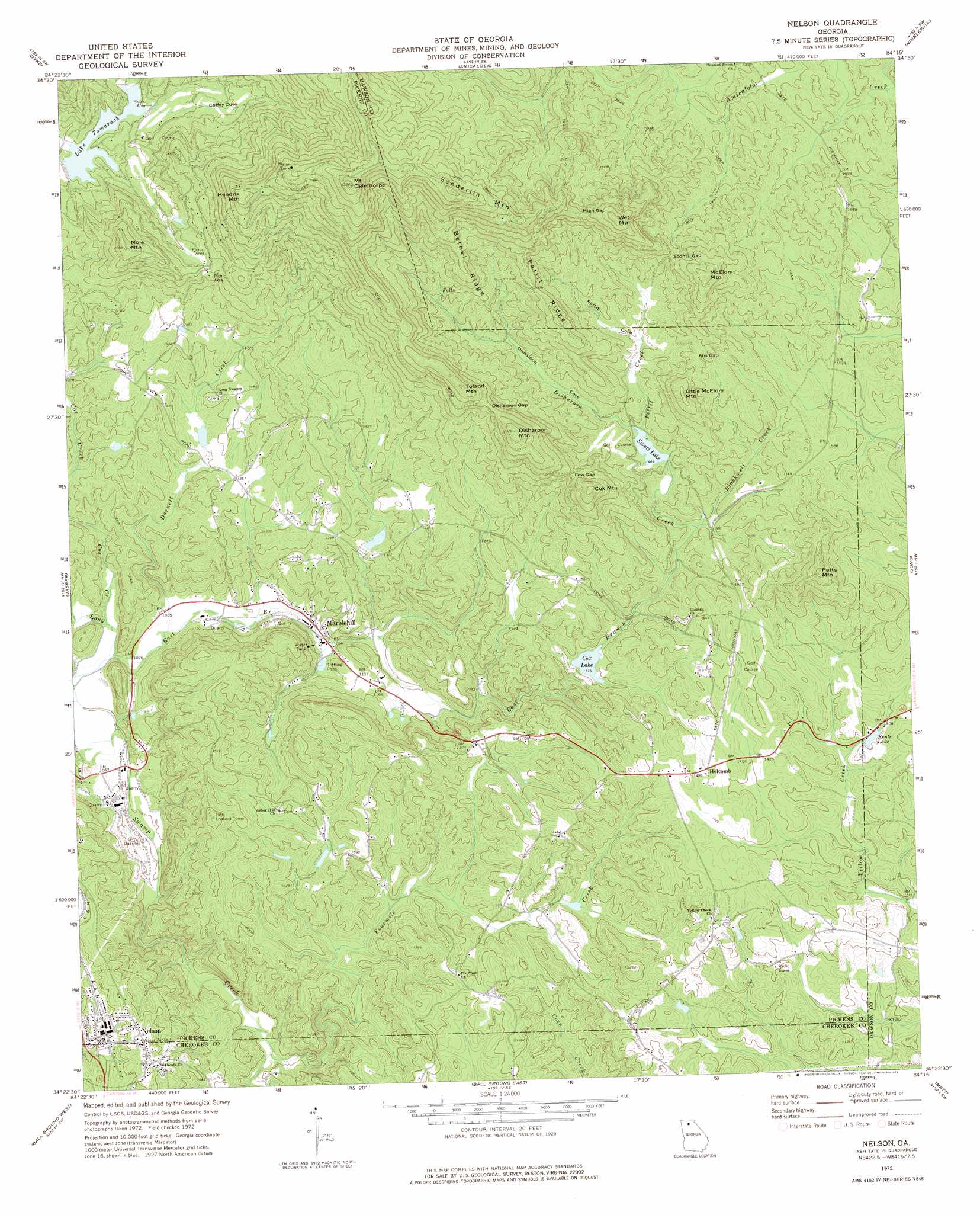
USGS Topo Quad 34084d3 - 1:24,000 scale
| Topo Map Name: | Nelson |
| USGS Topo Quad ID: | 34084d3 |
| Print Size: | ca. 21 1/4" wide x 27" high |
| Southeast Coordinates: | 34.375° N latitude / 84.25° W longitude |
| Map Center Coordinates: | 34.4375° N latitude / 84.3125° W longitude |
| U.S. State: | GA |
| Filename: | o34084d3.jpg |
| Download Map JPG Image: | Nelson topo map 1:24,000 scale |
| Map Type: | Topographic |
| Topo Series: | 7.5´ |
| Map Scale: | 1:24,000 |
| Source of Map Images: | United States Geological Survey (USGS) |
| Alternate Map Versions: |
Nelson GA 1972, updated 1975 Download PDF Buy paper map Nelson GA 1972, updated 1975 Download PDF Buy paper map Nelson GA 1997, updated 1999 Download PDF Buy paper map Nelson GA 2011 Download PDF Buy paper map Nelson GA 2014 Download PDF Buy paper map |
1:24,000 Topo Quads surrounding Nelson
Webb |
Ellijay |
Tickanetley |
Noontootla |
Suches |
Talking Rock |
Dyke |
Amicalola |
Nimblewill |
Campbell Mountain |
Ludville |
Jasper |
Nelson |
Juno |
Dawsonville |
Waleska |
Ball Ground West |
Ball Ground East |
Matt |
Coal Mountain |
South Canton |
Canton |
Birmingham |
Cumming |
Buford Dam |
> Back to 34084a1 at 1:100,000 scale
> Back to 34084a1 at 1:250,000 scale
> Back to U.S. Topo Maps home
Nelson topo map: Gazetteer
Nelson: Airports
Big Canoe Heliport elevation 447m 1466′Nelson: Bays
Coffey Cove elevation 512m 1679′Nelson: Dams
Bent Tree Dam elevation 454m 1489′Disharoon Lake Dam elevation 474m 1555′
Dubose Lake Dam elevation 425m 1394′
Harrison Lake Dam elevation 419m 1374′
Lake Petit Dam elevation 469m 1538′
Long Swamp Creek Watershed Dam Number Eight elevation 400m 1312′
Long Swamp Watershed Dam Number 14 elevation 396m 1299′
Long Swamp Watershed Dam Number 18 elevation 377m 1236′
Long Swamp Watershed Dam Number Nine elevation 396m 1299′
Sconti Lake Dam elevation 448m 1469′
Nelson: Gaps
Abs Gap elevation 531m 1742′Disharoon Gap elevation 641m 2103′
High Gap elevation 698m 2290′
Low Gap elevation 552m 1811′
Sconti Gap elevation 581m 1906′
Nelson: Populated Places
Daniels elevation 339m 1112′Holcomb elevation 442m 1450′
Marblehill elevation 330m 1082′
Nelson elevation 377m 1236′
Nelson: Post Offices
Marble Hill Post Office elevation 318m 1043′Nelson: Reservoirs
Anderson Lake elevation 396m 1299′Cox Lake elevation 396m 1299′
Disharoon Lake elevation 474m 1555′
Dubose Lake elevation 425m 1394′
Georgia Marble Company Lake elevation 400m 1312′
Harrison Lake elevation 419m 1374′
Kents Lake elevation 427m 1400′
Lake Petit elevation 469m 1538′
Lake Tamarack elevation 455m 1492′
Odum Lake elevation 377m 1236′
Sconti Lake elevation 448m 1469′
Nelson: Ridges
Bethel Ridge elevation 621m 2037′Pettit Ridge elevation 610m 2001′
Nelson: Streams
Blackwell Creek elevation 424m 1391′Cox Creek elevation 311m 1020′
Darnell Creek elevation 311m 1020′
Disharoon Creek elevation 424m 1391′
East Branch Long Swamp Creek elevation 311m 1020′
Fourmile Creek elevation 294m 964′
Pettit Creek elevation 451m 1479′
Nelson: Summits
Cox Mountain elevation 630m 2066′Disharoon Mountain elevation 694m 2276′
Hendrix Mountain elevation 832m 2729′
Little McElory Mountain elevation 609m 1998′
McElory Mountain elevation 673m 2208′
Mole Mountain elevation 669m 2194′
Mount Oglethorpe elevation 966m 3169′
Potts Mountain elevation 618m 2027′
Sanderlin Mountain elevation 910m 2985′
Toland Mountain elevation 725m 2378′
Wet Mountain elevation 758m 2486′
Nelson: Valleys
Disharoon Cove elevation 447m 1466′Pettit Cove elevation 490m 1607′
Nelson digital topo map on disk
Buy this Nelson topo map showing relief, roads, GPS coordinates and other geographical features, as a high-resolution digital map file on DVD: