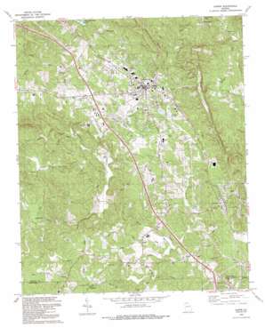
Jasper Topo Map Georgia
To zoom in, hover over the map of Jasper
USGS Topo Quad 34084d4 - 1:24,000 scale
| Topo Map Name: | Jasper |
| USGS Topo Quad ID: | 34084d4 |
| Print Size: | ca. 21 1/4" wide x 27" high |
| Southeast Coordinates: | 34.375° N latitude / 84.375° W longitude |
| Map Center Coordinates: | 34.4375° N latitude / 84.4375° W longitude |
| U.S. State: | GA |
| Filename: | o34084d4.jpg |
| Download Map JPG Image: | Jasper topo map 1:24,000 scale |
| Map Type: | Topographic |
| Topo Series: | 7.5´ |
| Map Scale: | 1:24,000 |
| Source of Map Images: | United States Geological Survey (USGS) |
| Alternate Map Versions: |
Jasper GA 1973, updated 1975 Download PDF Buy paper map Jasper GA 1973, updated 1986 Download PDF Buy paper map Jasper GA 1992, updated 1993 Download PDF Buy paper map Jasper GA 1997, updated 1999 Download PDF Buy paper map Jasper GA 2011 Download PDF Buy paper map Jasper GA 2014 Download PDF Buy paper map |
1:24,000 Topo Quads surrounding Jasper
> Back to 34084a1 at 1:100,000 scale
> Back to 34084a1 at 1:250,000 scale
> Back to U.S. Topo Maps home
Jasper topo map: Gazetteer
Jasper: Airports
Pickens County Airport elevation 462m 1515′Jasper: Dams
Bill Teague Lake Dam elevation 379m 1243′Georgia Marble Company Lake Dam elevation 344m 1128′
Griffith Lake Dam elevation 416m 1364′
Jewell Eaton Lake Dam elevation 358m 1174′
Lower Boswell Lake Dam elevation 369m 1210′
Perrow Lake Dam elevation 417m 1368′
Sharp Mountain Watershed Dam Number 12 elevation 396m 1299′
Sharp Mountain Watershed Dam Number 13 elevation 353m 1158′
Sharp Mountain Watershed Dam Number 14 elevation 353m 1158′
Sharp Mountain Watershed Dam Number 22 elevation 363m 1190′
Sharp Mountain Watershed Dam Number 28 elevation 395m 1295′
Sharp Mountain Watershed Dam Number 31 elevation 402m 1318′
Sharp Mountain Watershed Dam Number One elevation 375m 1230′
Sharp Mountain Watershed Dam Number Two elevation 373m 1223′
Twin Mountain Lakes Dam elevation 416m 1364′
Upper Boswell Lake Dam elevation 386m 1266′
Jasper: Falls
Padgett Falls elevation 416m 1364′Jasper: Parks
Jasper City Park elevation 443m 1453′Roper Park elevation 436m 1430′
Jasper: Populated Places
Cagle elevation 362m 1187′Grandview elevation 451m 1479′
Jasper elevation 446m 1463′
Ruden elevation 446m 1463′
Tate elevation 380m 1246′
West Brook elevation 452m 1482′
Worley Crossroads elevation 392m 1286′
Jasper: Post Offices
Jasper Post Office elevation 446m 1463′Tate Post Office elevation 391m 1282′
Jasper: Reservoirs
Bill Teague Lake elevation 379m 1243′Darnell Lake elevation 363m 1190′
Georgia Marble Company Lake elevation 344m 1128′
Griffith Lake elevation 416m 1364′
Jewell Eaton Lake elevation 358m 1174′
Jones Lake elevation 375m 1230′
Lagomarsino Lake elevation 373m 1223′
Lower Boswell Lake elevation 369m 1210′
Padgett Lake elevation 395m 1295′
Perrow Lake elevation 417m 1368′
Pittman-Shelton Lake elevation 396m 1299′
Reynolds Lake elevation 402m 1318′
Stephens Lake elevation 353m 1158′
Taylor Lake elevation 353m 1158′
Twin Mountain Lake elevation 416m 1364′
Upper Boswell Lake elevation 386m 1266′
Jasper: Streams
Cagle Branch elevation 327m 1072′Champion Creek elevation 364m 1194′
Hinton Creek elevation 336m 1102′
Pettit Creek elevation 370m 1213′
Polecat Branch elevation 327m 1072′
Rock Creek elevation 324m 1062′
Town Creek elevation 351m 1151′
Jasper digital topo map on disk
Buy this Jasper topo map showing relief, roads, GPS coordinates and other geographical features, as a high-resolution digital map file on DVD:


