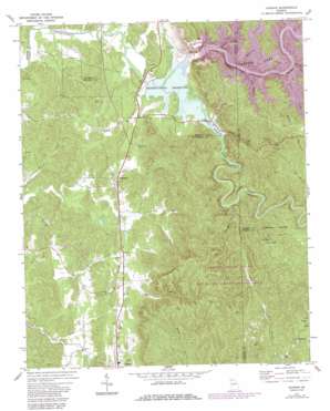
Oakman Topo Map Georgia
To zoom in, hover over the map of Oakman
USGS Topo Quad 34084e6 - 1:24,000 scale
| Topo Map Name: | Oakman |
| USGS Topo Quad ID: | 34084e6 |
| Print Size: | ca. 21 1/4" wide x 27" high |
| Southeast Coordinates: | 34.5° N latitude / 84.625° W longitude |
| Map Center Coordinates: | 34.5625° N latitude / 84.6875° W longitude |
| U.S. State: | GA |
| Filename: | o34084e6.jpg |
| Download Map JPG Image: | Oakman topo map 1:24,000 scale |
| Map Type: | Topographic |
| Topo Series: | 7.5´ |
| Map Scale: | 1:24,000 |
| Source of Map Images: | United States Geological Survey (USGS) |
| Alternate Map Versions: |
Oakman GA 1971, updated 1973 Download PDF Buy paper map Oakman GA 1971, updated 1986 Download PDF Buy paper map Oakman GA 2011 Download PDF Buy paper map Oakman GA 2014 Download PDF Buy paper map |
1:24,000 Topo Quads surrounding Oakman
> Back to 34084e1 at 1:100,000 scale
> Back to 34084a1 at 1:250,000 scale
> Back to U.S. Topo Maps home
Oakman topo map: Gazetteer
Oakman: Dams
Carters Dam elevation 305m 1000′Carters Reregulation Dam elevation 210m 688′
Evans Lake Dam elevation 241m 790′
Sallacoa Creek Watershed Dam Number 77 elevation 266m 872′
Tillman Lake Dam elevation 351m 1151′
Oakman: Parks
Damsite Recreation Area elevation 344m 1128′Harris Branch Recreation Area elevation 359m 1177′
Reregulation Dam Recreation Area elevation 208m 682′
Talking Rock Wildlife Management Area elevation 407m 1335′
Woodridge Branch Recreation Area elevation 359m 1177′
Oakman: Populated Places
Carters elevation 219m 718′Colima elevation 237m 777′
McDaniel elevation 403m 1322′
Oakman elevation 228m 748′
Petersburg elevation 233m 764′
Ranger elevation 228m 748′
Sweden elevation 361m 1184′
Wheeler (historical) elevation 210m 688′
Oakman: Post Offices
Oakman Post Office elevation 228m 748′Oakman: Reservoirs
Carters Lake elevation 305m 1000′Evans Lake elevation 241m 790′
Hopper Lake elevation 266m 872′
Reregulation Pool elevation 210m 688′
Reregulation Reservoir elevation 212m 695′
Tillman Lake elevation 351m 1151′
Oakman: Streams
Camp Branch elevation 327m 1072′Duke Creek elevation 206m 675′
Fisher Creek elevation 327m 1072′
Goble Branch elevation 327m 1072′
Harris Creek elevation 327m 1072′
Lewis Branch elevation 327m 1072′
Long Branch elevation 276m 905′
Mineral Springs Branch elevation 212m 695′
Raccoon Branch elevation 242m 793′
Rock Springs Branch elevation 209m 685′
Sevenmile Creek elevation 271m 889′
Sugar Creek elevation 203m 666′
Talking Rock Creek elevation 212m 695′
Willbanks Branch elevation 208m 682′
Wolf Branch elevation 212m 695′
Woodring Branch elevation 327m 1072′
Wurley Creek elevation 327m 1072′
Oakman digital topo map on disk
Buy this Oakman topo map showing relief, roads, GPS coordinates and other geographical features, as a high-resolution digital map file on DVD:


