Noontootla Topo Map Georgia
To zoom in, hover over the map of Noontootla
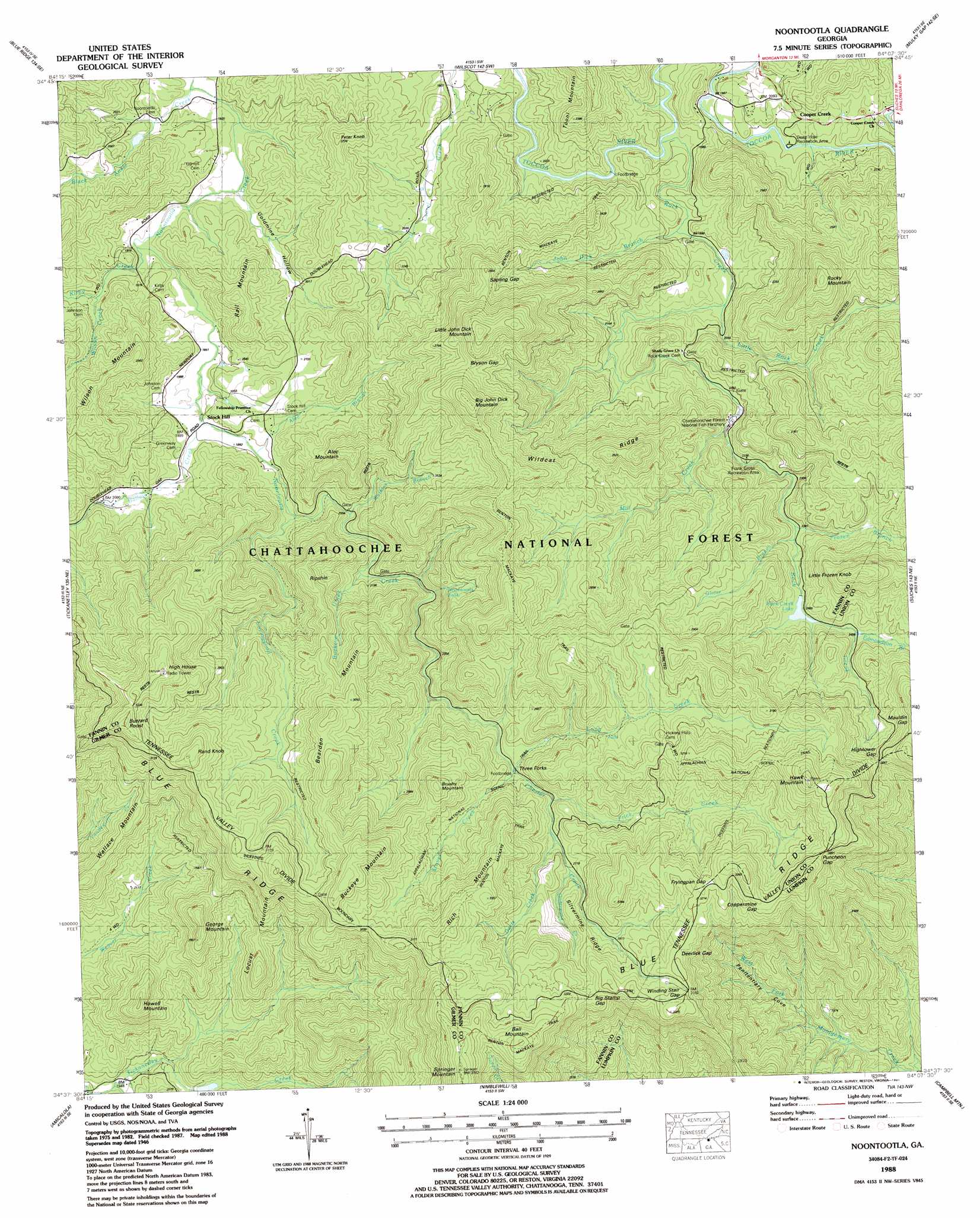
USGS Topo Quad 34084f2 - 1:24,000 scale
| Topo Map Name: | Noontootla |
| USGS Topo Quad ID: | 34084f2 |
| Print Size: | ca. 21 1/4" wide x 27" high |
| Southeast Coordinates: | 34.625° N latitude / 84.125° W longitude |
| Map Center Coordinates: | 34.6875° N latitude / 84.1875° W longitude |
| U.S. State: | GA |
| Filename: | o34084f2.jpg |
| Download Map JPG Image: | Noontootla topo map 1:24,000 scale |
| Map Type: | Topographic |
| Topo Series: | 7.5´ |
| Map Scale: | 1:24,000 |
| Source of Map Images: | United States Geological Survey (USGS) |
| Alternate Map Versions: |
Noontootla GA 1935 Download PDF Buy paper map Noontootla GA 1946, updated 1956 Download PDF Buy paper map Noontootla GA 1946, updated 1965 Download PDF Buy paper map Noontootla GA 1947, updated 1947 Download PDF Buy paper map Noontootla GA 1988, updated 1988 Download PDF Buy paper map Noontootla GA 1988, updated 1991 Download PDF Buy paper map Noontootla GA 2011 Download PDF Buy paper map Noontootla GA 2014 Download PDF Buy paper map |
| FStopo: | US Forest Service topo Noontootla is available: Download FStopo PDF Download FStopo TIF |
1:24,000 Topo Quads surrounding Noontootla
Epworth |
Mineral Bluff |
Culberson |
Nottely Dam |
Blairsville |
Cashes Valley |
Blue Ridge |
Wilscot |
Mulky Gap |
Coosa Bald |
Ellijay |
Tickanetley |
Noontootla |
Suches |
Neels Gap |
Dyke |
Amicalola |
Nimblewill |
Campbell Mountain |
Dahlonega |
Jasper |
Nelson |
Juno |
Dawsonville |
Murrayville |
> Back to 34084e1 at 1:100,000 scale
> Back to 34084a1 at 1:250,000 scale
> Back to U.S. Topo Maps home
Noontootla topo map: Gazetteer
Noontootla: Bays
Penitentiary Cove elevation 566m 1856′Noontootla: Dams
Cartecay River Watershed Dam Number Seven elevation 628m 2060′Rock Creek Lake Dam elevation 751m 2463′
Van Orsdal Lake Dam elevation 597m 1958′
Noontootla: Falls
High Falls elevation 700m 2296′Noontootla Falls elevation 775m 2542′
Noontootla: Flats
Hickory Flats elevation 895m 2936′Noontootla: Gaps
Big Stamp Gap elevation 951m 3120′Bryson Gap elevation 880m 2887′
Coppermine Gap elevation 992m 3254′
Deerlick Gap elevation 969m 3179′
Fryingpan Gap elevation 982m 3221′
Hightower Gap elevation 866m 2841′
Puncheon Gap elevation 976m 3202′
Sapling Gap elevation 832m 2729′
Winding Stair Gap elevation 971m 3185′
Noontootla: Parks
Blue Ridge Wildlife Management Area elevation 951m 3120′Noontootla: Populated Places
Argo (historical) elevation 714m 2342′Cooper Creek elevation 640m 2099′
Newport elevation 600m 1968′
Stock Hill elevation 599m 1965′
Three Forks elevation 766m 2513′
Wilson Mill elevation 680m 2230′
Noontootla: Ranges
John Dick Mountains elevation 946m 3103′Noontootla: Reservoirs
Little Lake elevation 628m 2060′Rock Creek Lake elevation 751m 2463′
Van Orsdal Lake elevation 597m 1958′
Noontootla: Ridges
Silvermine Ridge elevation 917m 3008′Wildcat Ridge elevation 845m 2772′
Noontootla: Streams
Alec Branch elevation 604m 1981′Bailey Creek elevation 598m 1961′
Black Ankle Creek elevation 568m 1863′
Buckeye Creek elevation 653m 2142′
Bucktown Creek elevation 589m 1932′
Chester Creek elevation 727m 2385′
Davis Creek elevation 814m 2670′
Edmondson Branch elevation 757m 2483′
Frick Creek elevation 794m 2604′
Frozen Branch elevation 710m 2329′
John Dick Branch elevation 606m 1988′
Kirby Creek elevation 579m 1899′
Little Rock Creek elevation 617m 2024′
Long Creek elevation 766m 2513′
Lovinggood Creek elevation 624m 2047′
Mill Creek elevation 679m 2227′
Oliver Branch elevation 715m 2345′
Rock Creek elevation 591m 1938′
Stover Creek elevation 769m 2522′
Underwood Creek elevation 823m 2700′
Watkins Branch elevation 637m 2089′
Wilson Creek elevation 595m 1952′
Noontootla: Summits
Alec Mountain elevation 829m 2719′Ball Mountain elevation 1109m 3638′
Bearden Mountain elevation 990m 3248′
Big John Dick Mountain elevation 999m 3277′
Brushy Mountain elevation 954m 3129′
Buckeye Mountain elevation 1000m 3280′
Buzzard Roost elevation 1020m 3346′
George Mountain elevation 883m 2896′
Hawk Mountain elevation 1089m 3572′
High House elevation 1038m 3405′
Howell Mountain elevation 850m 2788′
Little Frozen Knob elevation 961m 3152′
Little John Dick Mountain elevation 999m 3277′
Locust Mountain elevation 780m 2559′
Peter Knob elevation 746m 2447′
Rall Mountain elevation 723m 2372′
Rand Knob elevation 1012m 3320′
Rich Mountain elevation 1005m 3297′
Ripshin elevation 845m 2772′
Rocky Mountain elevation 941m 3087′
Sids Mountain elevation 784m 2572′
Springer Mountain elevation 1148m 3766′
Wallace Mountain elevation 818m 2683′
Wilson Mountain elevation 790m 2591′
Noontootla: Valleys
Goldmine Hollow elevation 572m 1876′Noontootla digital topo map on disk
Buy this Noontootla topo map showing relief, roads, GPS coordinates and other geographical features, as a high-resolution digital map file on DVD: