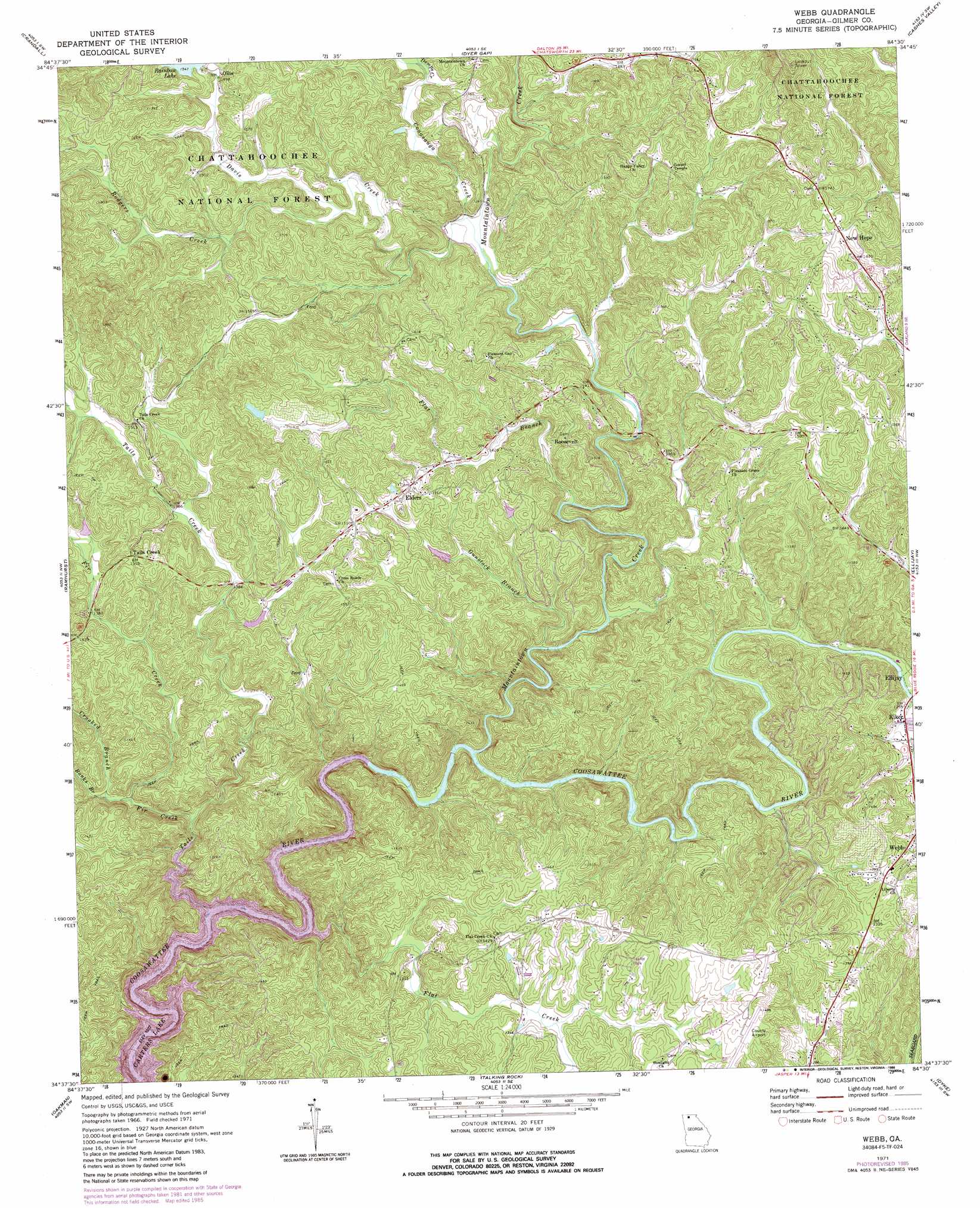
Webb Topo Map Georgia
To zoom in, hover over the map of Webb
USGS Topo Quad 34084f5 - 1:24,000 scale
| Topo Map Name: | Webb |
| USGS Topo Quad ID: | 34084f5 |
| Print Size: | ca. 21 1/4" wide x 27" high |
| Southeast Coordinates: | 34.625° N latitude / 84.5° W longitude |
| Map Center Coordinates: | 34.6875° N latitude / 84.5625° W longitude |
| U.S. State: | GA |
| Filename: | o34084f5.jpg |
| Download Map JPG Image: | Webb topo map 1:24,000 scale |
| Map Type: | Topographic |
| Topo Series: | 7.5´ |
| Map Scale: | 1:24,000 |
| Source of Map Images: | United States Geological Survey (USGS) |
| Alternate Map Versions: |
Webb GA 1971, updated 1973 Download PDF Buy paper map Webb GA 2011 Download PDF Buy paper map Webb GA 2014 Download PDF Buy paper map |
| FStopo: | US Forest Service topo Webb is available: Download FStopo PDF Download FStopo TIF |
1:24,000 Topo Quads surrounding Webb
Beaverdale |
Tennga |
Hemp Top |
Epworth |
Mineral Bluff |
Chatsworth |
Crandall |
Dyer Gap |
Cashes Valley |
Blue Ridge |
Calhoun Ne |
Ramhurst |
Webb |
Ellijay |
Tickanetley |
Redbud |
Oakman |
Talking Rock |
Dyke |
Amicalola |
Sonoraville |
Fairmount |
Ludville |
Jasper |
Nelson |
> Back to 34084e1 at 1:100,000 scale
> Back to 34084a1 at 1:250,000 scale
> Back to U.S. Topo Maps home
Webb topo map: Gazetteer
Webb: Airports
Gilmer County Airport elevation 442m 1450′Webb: Dams
Chitwood Lake Dam elevation 418m 1371′Webb: Parks
Ridgeway Recreation Area elevation 397m 1302′Webb: Populated Places
Elders elevation 454m 1489′Kiker elevation 381m 1250′
New Hope elevation 506m 1660′
Ollie elevation 455m 1492′
Ratcliff (historical) elevation 413m 1354′
Roosevelt elevation 441m 1446′
Tails Creek elevation 461m 1512′
Webb elevation 404m 1325′
Webb: Reservoirs
Chitwood Lake elevation 418m 1371′Rainbow Lake elevation 469m 1538′
Webb: Streams
Banks Branch elevation 364m 1194′Conasauga Creek elevation 406m 1332′
Crooked Branch elevation 361m 1184′
Davis Creek elevation 407m 1335′
Demps Creek elevation 420m 1377′
Fir Creek elevation 347m 1138′
Flat Branch elevation 373m 1223′
Flat Creek elevation 327m 1072′
Gunstock Branch elevation 354m 1161′
Mountaintown Creek elevation 338m 1108′
Rodgers Creek elevation 444m 1456′
Tails Creek elevation 327m 1072′
Webb digital topo map on disk
Buy this Webb topo map showing relief, roads, GPS coordinates and other geographical features, as a high-resolution digital map file on DVD: