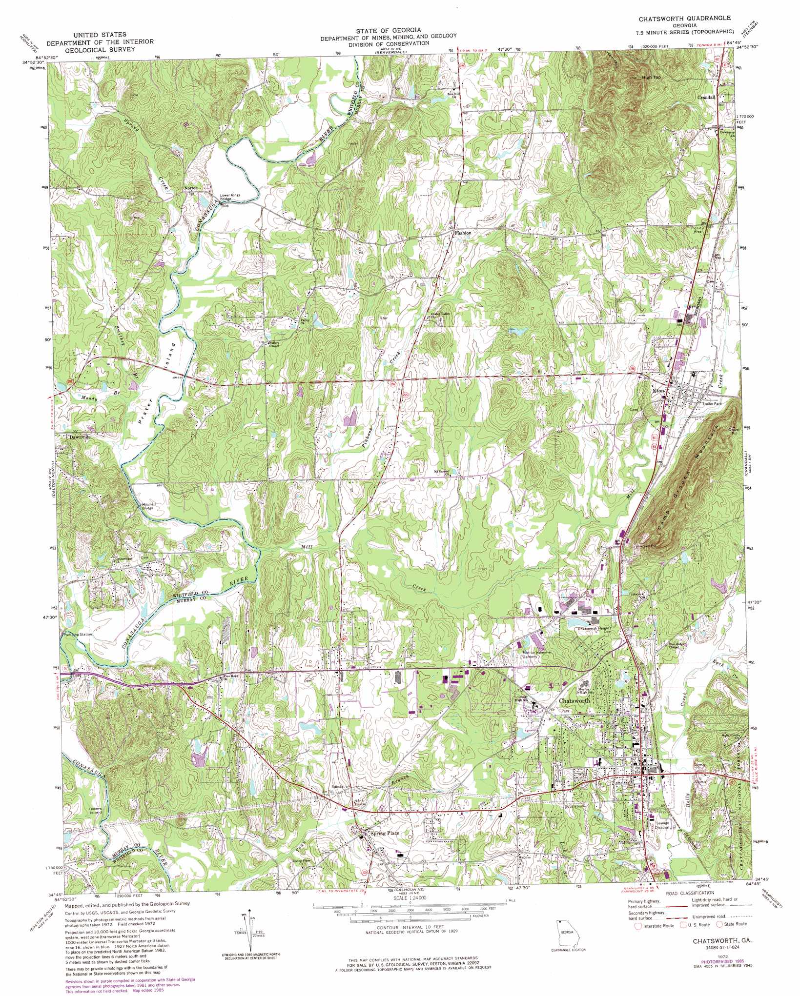
Chatsworth Topo Map Georgia
To zoom in, hover over the map of Chatsworth
USGS Topo Quad 34084g7 - 1:24,000 scale
| Topo Map Name: | Chatsworth |
| USGS Topo Quad ID: | 34084g7 |
| Print Size: | ca. 21 1/4" wide x 27" high |
| Southeast Coordinates: | 34.75° N latitude / 84.75° W longitude |
| Map Center Coordinates: | 34.8125° N latitude / 84.8125° W longitude |
| U.S. State: | GA |
| Filename: | o34084g7.jpg |
| Download Map JPG Image: | Chatsworth topo map 1:24,000 scale |
| Map Type: | Topographic |
| Topo Series: | 7.5´ |
| Map Scale: | 1:24,000 |
| Source of Map Images: | United States Geological Survey (USGS) |
| Alternate Map Versions: |
Chatsworth GA 1972, updated 1974 Download PDF Buy paper map Chatsworth GA 1972, updated 1986 Download PDF Buy paper map Chatsworth GA 2011 Download PDF Buy paper map Chatsworth GA 2014 Download PDF Buy paper map |
| FStopo: | US Forest Service topo Chatsworth is available: Download FStopo PDF Download FStopo TIF |
1:24,000 Topo Quads surrounding Chatsworth
Ooltewah |
Mcdonald |
Felker |
Parksville |
Caney Creek |
Ringgold |
Cohutta |
Beaverdale |
Tennga |
Hemp Top |
Tunnel Hill |
Dalton North |
Chatsworth |
Crandall |
Dyer Gap |
Villanow |
Dalton South |
Calhoun Ne |
Ramhurst |
Webb |
Sugar Valley |
Calhoun North |
Redbud |
Oakman |
Talking Rock |
> Back to 34084e1 at 1:100,000 scale
> Back to 34084a1 at 1:250,000 scale
> Back to U.S. Topo Maps home
Chatsworth topo map: Gazetteer
Chatsworth: Airports
R M Harris Airport elevation 239m 784′Chatsworth: Bridges
B T Parks Memorial Bridge elevation 219m 718′C W Bradley Bridge elevation 222m 728′
Goswick Bridge elevation 209m 685′
Lower Kings Bridge elevation 208m 682′
Mitchell Bridge elevation 210m 688′
Chatsworth: Crossings
Gudger Forst elevation 210m 688′Harris Ford elevation 210m 688′
Old Chattanooga Ford elevation 204m 669′
Chatsworth: Dams
Fort Mountain Spinners Lake Dam elevation 227m 744′Lents Lake Dam elevation 244m 800′
Chatsworth: Islands
Felkers Island elevation 201m 659′Prater Island elevation 208m 682′
Chatsworth: Populated Places
Chatsworth elevation 227m 744′Eton elevation 228m 748′
Fort Mountain (historical) elevation 251m 823′
Norton elevation 222m 728′
Oran elevation 238m 780′
Spring Place elevation 216m 708′
Treadwell elevation 209m 685′
Chatsworth: Reservoirs
Fort Mountain Spinners Lake elevation 227m 744′Lents Lake elevation 244m 800′
Chatsworth: Streams
Mill Creek elevation 203m 666′Moody Branch elevation 206m 675′
Nickolson Branch elevation 213m 698′
Pinhook Creek elevation 205m 672′
Rock Creek elevation 222m 728′
Smithey Branch elevation 207m 679′
Spring Creek elevation 207m 679′
Chatsworth: Summits
Camp Ground Mountain elevation 338m 1108′High Top elevation 338m 1108′
Chatsworth digital topo map on disk
Buy this Chatsworth topo map showing relief, roads, GPS coordinates and other geographical features, as a high-resolution digital map file on DVD: