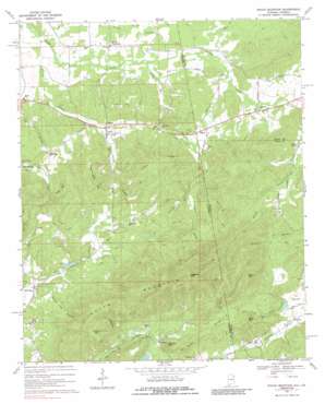
Indian Mountain Topo Map Alabama
To zoom in, hover over the map of Indian Mountain
USGS Topo Quad 34085a4 - 1:24,000 scale
| Topo Map Name: | Indian Mountain |
| USGS Topo Quad ID: | 34085a4 |
| Print Size: | ca. 21 1/4" wide x 27" high |
| Southeast Coordinates: | 34° N latitude / 85.375° W longitude |
| Map Center Coordinates: | 34.0625° N latitude / 85.4375° W longitude |
| U.S. States: | AL, GA |
| Filename: | o34085a4.jpg |
| Download Map JPG Image: | Indian Mountain topo map 1:24,000 scale |
| Map Type: | Topographic |
| Topo Series: | 7.5´ |
| Map Scale: | 1:24,000 |
| Source of Map Images: | United States Geological Survey (USGS) |
| Alternate Map Versions: |
Indian Mountain AL 1967, updated 1969 Download PDF Buy paper map Indian Mountain AL 1967, updated 1969 Download PDF Buy paper map Indian Mountain AL 1967, updated 1987 Download PDF Buy paper map Indian Mountain AL 2011 Download PDF Buy paper map Indian Mountain AL 2011 Download PDF Buy paper map Indian Mountain AL 2014 Download PDF Buy paper map |
| FStopo: | US Forest Service topo Indian Mountain is available: Download FStopo PDF Download FStopo TIF |
1:24,000 Topo Quads surrounding Indian Mountain
> Back to 34085a1 at 1:100,000 scale
> Back to 34084a1 at 1:250,000 scale
> Back to U.S. Topo Maps home
Indian Mountain topo map: Gazetteer
Indian Mountain: Dams
Terrapin Creek Watershed Dam Number 17 elevation 262m 859′Indian Mountain: Mines
Bustup Mine elevation 305m 1000′Indian Mine elevation 303m 994′
Klondike Mine elevation 272m 892′
Monahan Mine elevation 273m 895′
New Dykes Cut Mine elevation 297m 974′
Old Dykes Cut Mine elevation 299m 980′
Stonewall Mine elevation 307m 1007′
Texas Cut Mine elevation 302m 990′
Warhoop Mine elevation 301m 987′
Indian Mountain: Populated Places
Adams Crossroads elevation 224m 734′Bauxite elevation 267m 875′
Bluffton elevation 259m 849′
Etna elevation 273m 895′
Fearing (historical) elevation 277m 908′
Forney elevation 214m 702′
Haney elevation 220m 721′
Hanson elevation 221m 725′
McCord Crossroads elevation 195m 639′
Prior elevation 254m 833′
Rock Run elevation 223m 731′
Sandy Springs elevation 210m 688′
Sidhart (historical) elevation 249m 816′
Indian Mountain: Reservoirs
Terrapin Creek Lake Number 17 elevation 262m 859′Indian Mountain: Ridges
Indian Mountain elevation 463m 1519′Poplar Ridge elevation 336m 1102′
Indian Mountain: Springs
Log Hollow Spring elevation 343m 1125′Indian Mountain: Streams
Forney Branch elevation 182m 597′Indian Branch elevation 247m 810′
Lumpkin Mill Creek elevation 190m 623′
Sal Brown Branch elevation 254m 833′
Sat Brown Branch elevation 259m 849′
Indian Mountain: Summits
Bluffton Mountain elevation 368m 1207′Etna Mountain elevation 373m 1223′
Flagpole Mountain elevation 598m 1961′
Frost Mountain elevation 343m 1125′
Shorty Mountain elevation 485m 1591′
Suzanne Davis Mountain elevation 344m 1128′
Vineyard Mountain elevation 417m 1368′
Indian Mountain: Valleys
Hawkins Hollow elevation 252m 826′Pump Log Hollow elevation 228m 748′
Indian Mountain digital topo map on disk
Buy this Indian Mountain topo map showing relief, roads, GPS coordinates and other geographical features, as a high-resolution digital map file on DVD:


