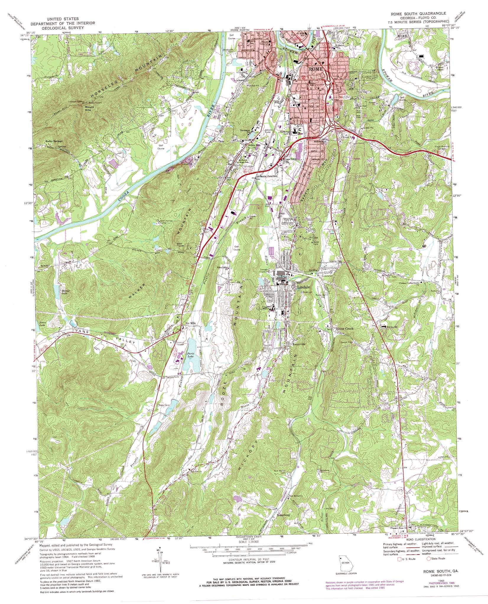
Rome South Topo Map Georgia
To zoom in, hover over the map of Rome South
USGS Topo Quad 34085b2 - 1:24,000 scale
| Topo Map Name: | Rome South |
| USGS Topo Quad ID: | 34085b2 |
| Print Size: | ca. 21 1/4" wide x 27" high |
| Southeast Coordinates: | 34.125° N latitude / 85.125° W longitude |
| Map Center Coordinates: | 34.1875° N latitude / 85.1875° W longitude |
| U.S. State: | GA |
| Filename: | o34085b2.jpg |
| Download Map JPG Image: | Rome South topo map 1:24,000 scale |
| Map Type: | Topographic |
| Topo Series: | 7.5´ |
| Map Scale: | 1:24,000 |
| Source of Map Images: | United States Geological Survey (USGS) |
| Alternate Map Versions: |
Rome South GA 1968, updated 1970 Download PDF Buy paper map Rome South GA 1968, updated 1986 Download PDF Buy paper map Rome South GA 1968, updated 1986 Download PDF Buy paper map Rome South GA 2011 Download PDF Buy paper map Rome South GA 2014 Download PDF Buy paper map |
1:24,000 Topo Quads surrounding Rome South
Lyerly |
Summerville |
Armuchee |
Plainville |
Calhoun South |
Chattoogaville |
Rock Mountain |
Rome North |
Shannon |
Adairsville |
Melson |
Livingston |
Rome South |
Wax |
Kingston |
Indian Mountain |
Cedartown West |
Cedartown East |
Rockmart North |
Tayorsville |
Borden Springs |
Benedict |
Felton |
Rockmart South |
Yorkville |
> Back to 34085a1 at 1:100,000 scale
> Back to 34084a1 at 1:250,000 scale
> Back to U.S. Topo Maps home
Rome South topo map: Gazetteer
Rome South: Bridges
East Rome Bridge elevation 177m 580′Rome South: Cliffs
Blacks Bluff elevation 192m 629′Rome South: Dams
Martens Lake Dam elevation 191m 626′North Jones Lake Dam elevation 193m 633′
Paris Lake Dam elevation 208m 682′
Powers Lake Dam Number One elevation 219m 718′
Powers Lake Dam Number Two elevation 225m 738′
Rome South: Mines
Six Mile Quarry elevation 240m 787′Rome South: Parks
East Rome Historic District elevation 194m 636′Parks Hoke Park elevation 183m 600′
Rome South: Populated Places
Atlanta Junction elevation 185m 606′Boozeville elevation 211m 692′
Callier Springs Heights elevation 229m 751′
Castle Cove elevation 219m 718′
Chapel Hill elevation 195m 639′
Chulio Hills elevation 205m 672′
Forrest Heights elevation 226m 741′
Gaither Park elevation 201m 659′
Horseleg Estates elevation 203m 666′
Horseshoe Bend elevation 209m 685′
John Graham Homes elevation 189m 620′
Lindale elevation 203m 666′
Maplewood Square elevation 186m 610′
Merry Acres elevation 189m 620′
New Rome elevation 189m 620′
Nottingham Estates elevation 268m 879′
Radio Springs elevation 240m 787′
Reeseburg elevation 242m 793′
Ridgedale elevation 215m 705′
Ridgewood Estates elevation 207m 679′
River Place elevation 189m 620′
River Ridge elevation 201m 659′
Rivermont elevation 213m 698′
Robealou Acres elevation 217m 711′
Rosemont Park elevation 214m 702′
Saddle Mountain elevation 251m 823′
Silver Creek elevation 210m 688′
Silvermont elevation 261m 856′
Six Mile elevation 213m 698′
Twickenham elevation 250m 820′
Woodpin Estates elevation 225m 738′
Rome South: Post Offices
Lindale Post Office elevation 198m 649′Silver Creek Post Office elevation 246m 807′
Rome South: Reservoirs
DeSoto Lake elevation 189m 620′Martens Lake elevation 191m 626′
Milner Lake elevation 181m 593′
North Jones Lake elevation 193m 633′
Paris Lake elevation 208m 682′
Powers Lake Number One elevation 219m 718′
Powers Lake Number Two elevation 225m 738′
Rome South: Springs
DeSoto Park Spring elevation 189m 620′Glen Alto Spring elevation 240m 787′
Rome South: Streams
Booze Creek elevation 195m 639′Prentis Branch elevation 183m 600′
Silver Creek elevation 177m 580′
Rome South: Summits
Booze Mountain elevation 304m 997′Hickory Mountain elevation 324m 1062′
Horseleg Mountain elevation 403m 1322′
Mount Alto elevation 456m 1496′
Saddle Mountain elevation 285m 935′
Walker Mountain elevation 288m 944′
Rome South: Woods
Marshall Forest elevation 209m 685′Rome South digital topo map on disk
Buy this Rome South topo map showing relief, roads, GPS coordinates and other geographical features, as a high-resolution digital map file on DVD: