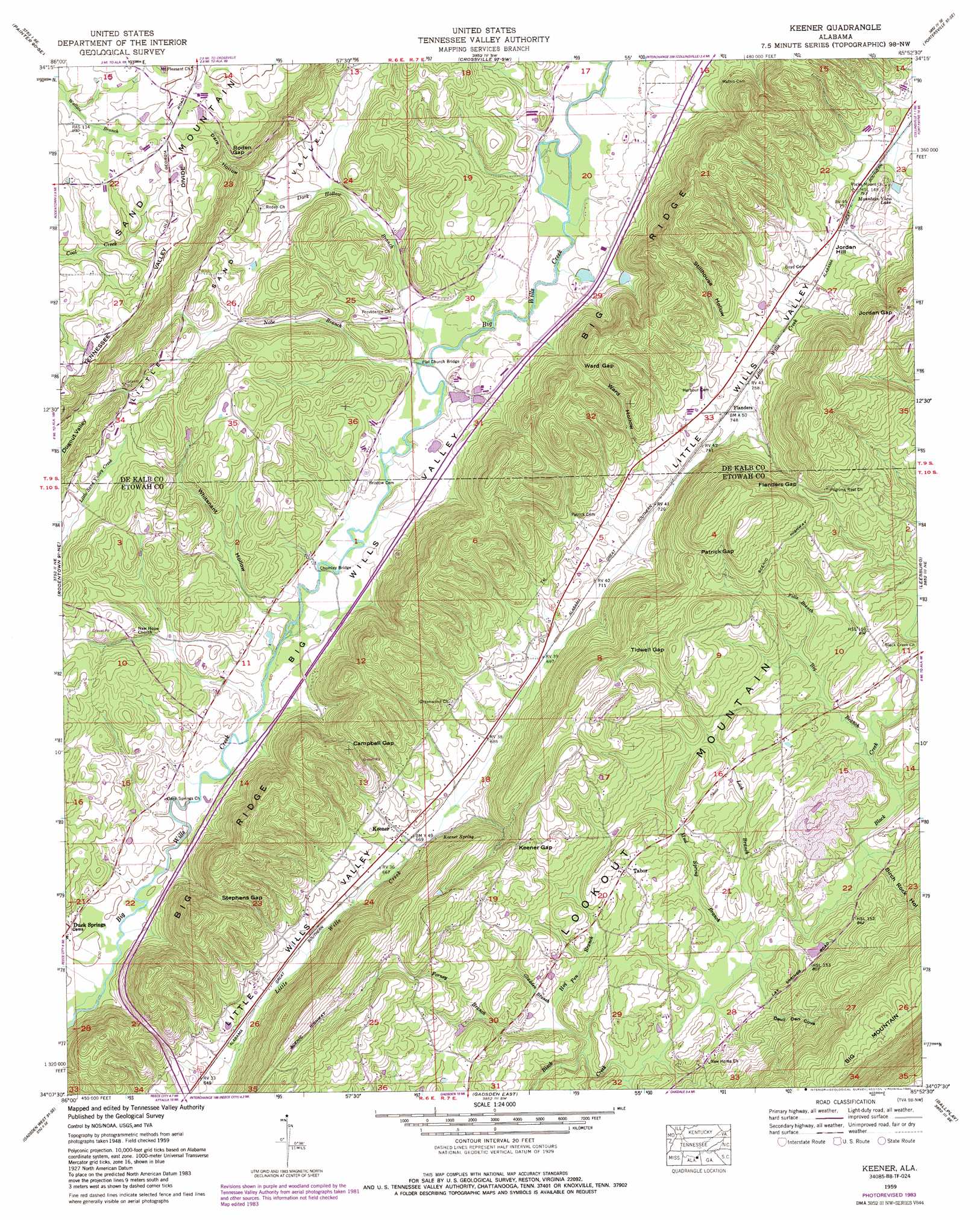
Keener Topo Map Alabama
To zoom in, hover over the map of Keener
USGS Topo Quad 34085b8 - 1:24,000 scale
| Topo Map Name: | Keener |
| USGS Topo Quad ID: | 34085b8 |
| Print Size: | ca. 21 1/4" wide x 27" high |
| Southeast Coordinates: | 34.125° N latitude / 85.875° W longitude |
| Map Center Coordinates: | 34.1875° N latitude / 85.9375° W longitude |
| U.S. State: | AL |
| Filename: | o34085b8.jpg |
| Download Map JPG Image: | Keener topo map 1:24,000 scale |
| Map Type: | Topographic |
| Topo Series: | 7.5´ |
| Map Scale: | 1:24,000 |
| Source of Map Images: | United States Geological Survey (USGS) |
| Alternate Map Versions: |
Roden Gap AL 1936 Download PDF Buy paper map Keener AL 1959, updated 1960 Download PDF Buy paper map Keener AL 1959, updated 1975 Download PDF Buy paper map Keener AL 1959, updated 1985 Download PDF Buy paper map Keener AL 2011 Download PDF Buy paper map Keener AL 2014 Download PDF Buy paper map |
1:24,000 Topo Quads surrounding Keener
Columbus City |
Grove Oak |
Fyffe |
Chavies |
Fort Payne |
Albertville |
Painter |
Crossville |
Portersville |
Little River |
Boaz |
Rodentown |
Keener |
Leesburg |
Centre |
Howelton |
Gadsden West |
Gadsden East |
Ballplay |
Weisner Mountain |
Steele |
Dunaway Mountain |
Glencoe |
Colvin Gap |
Piedmont Nw |
> Back to 34085a1 at 1:100,000 scale
> Back to 34084a1 at 1:250,000 scale
> Back to U.S. Topo Maps home
Keener topo map: Gazetteer
Keener: Bridges
Chumley Bridge elevation 187m 613′Duck Springs Covered Bridge (historical) elevation 183m 600′
Flat Church Bridge elevation 190m 623′
Smiths Bridge (historical) elevation 182m 597′
Stephens Bridge elevation 182m 597′
Keener: Dams
John Gilbreath Number 1 Dam elevation 286m 938′Smith Dam elevation 192m 629′
Keener: Gaps
Campbell Gap elevation 292m 958′Flanders Gap elevation 309m 1013′
Jordan Gap elevation 340m 1115′
Keener Gap elevation 296m 971′
Patrick Gap elevation 330m 1082′
Roden Gap elevation 321m 1053′
Stephens Gap elevation 260m 853′
Tidwell Gap elevation 327m 1072′
Ward Gap elevation 275m 902′
Keener: Populated Places
Black Creek elevation 244m 800′Chumley (historical) elevation 193m 633′
Duck Springs elevation 190m 623′
Flanders elevation 229m 751′
Greenwood elevation 226m 741′
Hendrixville elevation 193m 633′
Keener elevation 206m 675′
Marcus (historical) elevation 235m 770′
Smiths Bridge (historical) elevation 186m 610′
Tabor elevation 252m 826′
Yancy elevation 191m 626′
Keener: Post Offices
Greenwood Post Office elevation 226m 741′Keener: Reservoirs
John Gilbreath Number 1 Lake elevation 286m 938′Mountain View Lake elevation 243m 797′
Ray Smiths Lake elevation 192m 629′
Keener: Springs
Duck Springs elevation 189m 620′Keener Spring elevation 210m 688′
Yancey Spring elevation 190m 623′
Keener: Streams
Big Branch elevation 232m 761′Dark Hollow Branch elevation 190m 623′
Falls Branch elevation 242m 793′
Forney Branch elevation 222m 728′
Gladden Branch elevation 222m 728′
Hog Pen Branch elevation 223m 731′
Lick Branch elevation 230m 754′
Little Sand Valley Creek elevation 180m 590′
Mud Spring Branch elevation 229m 751′
Nobe Branch elevation 191m 626′
Spring Branch elevation 231m 757′
Keener: Summits
Jordan Hill elevation 249m 816′Keener: Valleys
Birch Rock Hollow elevation 232m 761′Dark Hollow elevation 222m 728′
Devil Den Cove elevation 231m 757′
Stillhouse Hollow elevation 243m 797′
Ward Hollow elevation 242m 793′
Whitsnant Hollow elevation 192m 629′
Keener digital topo map on disk
Buy this Keener topo map showing relief, roads, GPS coordinates and other geographical features, as a high-resolution digital map file on DVD: