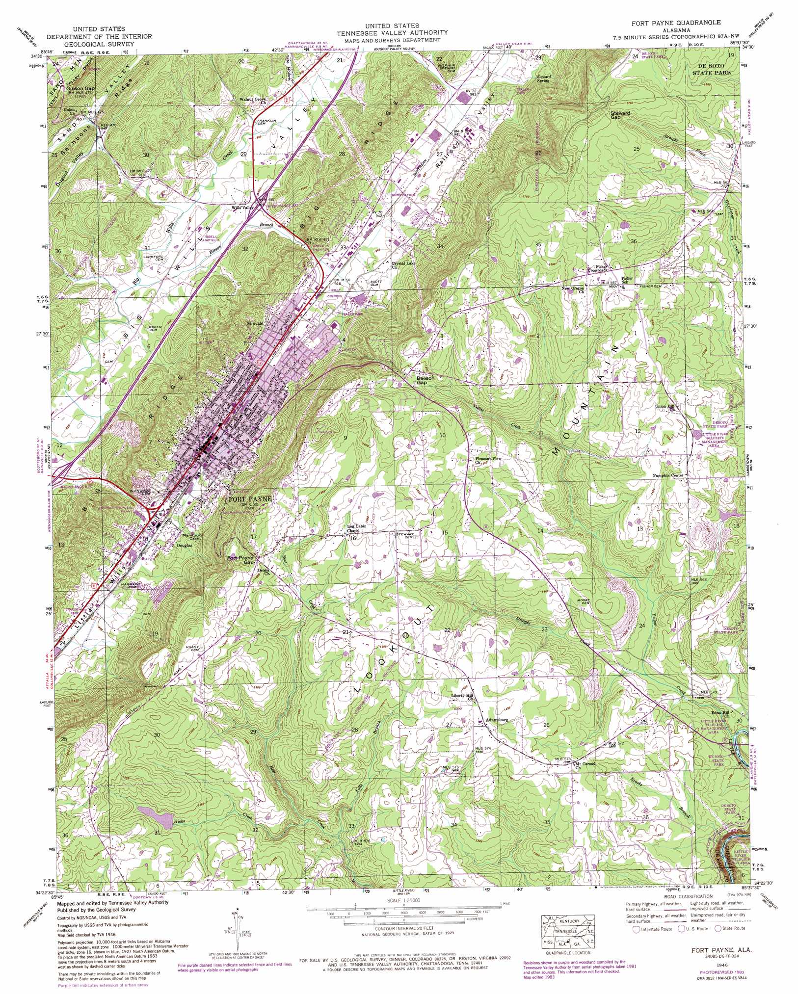
Fort Payne Topo Map Alabama
To zoom in, hover over the map of Fort Payne
USGS Topo Quad 34085d6 - 1:24,000 scale
| Topo Map Name: | Fort Payne |
| USGS Topo Quad ID: | 34085d6 |
| Print Size: | ca. 21 1/4" wide x 27" high |
| Southeast Coordinates: | 34.375° N latitude / 85.625° W longitude |
| Map Center Coordinates: | 34.4375° N latitude / 85.6875° W longitude |
| U.S. State: | AL |
| Filename: | o34085d6.jpg |
| Download Map JPG Image: | Fort Payne topo map 1:24,000 scale |
| Map Type: | Topographic |
| Topo Series: | 7.5´ |
| Map Scale: | 1:24,000 |
| Source of Map Images: | United States Geological Survey (USGS) |
| Alternate Map Versions: |
Ft Payne AL 1946, updated 1960 Download PDF Buy paper map Ft Payne AL 1946, updated 1967 Download PDF Buy paper map Fort Payne AL 1946, updated 1972 Download PDF Buy paper map Fort Payne AL 1946, updated 1978 Download PDF Buy paper map Fort Payne AL 1946, updated 1984 Download PDF Buy paper map Ft Payne AL 1947, updated 1947 Download PDF Buy paper map Fort Payne AL 2011 Download PDF Buy paper map Fort Payne AL 2014 Download PDF Buy paper map |
1:24,000 Topo Quads surrounding Fort Payne
Hollywood |
Henagar |
Ider |
Sulphur Springs |
Cedar Grove |
Dutton |
Sylvania |
Dugout Valley |
Valley Head |
Dougherty Gap |
Fyffe |
Chavies |
Fort Payne |
Jamestown |
Lyerly |
Crossville |
Portersville |
Little River |
Gaylesville |
Chattoogaville |
Keener |
Leesburg |
Centre |
Cedar Bluff |
Melson |
> Back to 34085a1 at 1:100,000 scale
> Back to 34084a1 at 1:250,000 scale
> Back to U.S. Topo Maps home
Fort Payne topo map: Gazetteer
Fort Payne: Airports
Isbell Field elevation 264m 866′Jennings Aeropark elevation 422m 1384′
Fort Payne: Crossings
Interchange 218 elevation 250m 820′Interchange 222 elevation 275m 902′
Fort Payne: Dams
Rotch and Cassidy Dam elevation 402m 1318′Temple Dam elevation 414m 1358′
Fort Payne: Falls
Little River Falls elevation 350m 1148′Fort Payne: Gaps
Beeson Gap elevation 450m 1476′Fort Payne Gap elevation 464m 1522′
Gibson Gap elevation 411m 1348′
Steward Gap elevation 511m 1676′
Fort Payne: Parks
City Park elevation 274m 898′Fort Payne Boom Town Historic District elevation 275m 902′
Fort Payne Main Street Historic District elevation 275m 902′
Fort Payne Residential Historic District elevation 284m 931′
Manitou Park elevation 279m 915′
Williams Avenue Athletic Facilities elevation 287m 941′
Fort Payne: Populated Places
Adamsburg elevation 447m 1466′Douglas elevation 282m 925′
Fisher Crossroads elevation 505m 1656′
Fort Payne elevation 275m 902′
Minvale elevation 303m 994′
Pumpkin Center elevation 445m 1459′
Rawlingsville (historical) elevation 292m 958′
Wills Valley elevation 270m 885′
Fort Payne: Post Offices
Fort Payne Post Office elevation 272m 892′Fort Payne: Reservoirs
Rotch and Cassidy Lake elevation 402m 1318′Temples Lake elevation 414m 1358′
Fort Payne: Springs
Manitou Spring elevation 273m 895′Steward Spring elevation 296m 971′
Fort Payne: Streams
Beeson Branch elevation 254m 833′Brooks Branch elevation 298m 977′
Falls Branch elevation 348m 1141′
Hicks Creek elevation 352m 1154′
Straight Creek elevation 372m 1220′
Yellow Creek elevation 356m 1167′
Fort Payne: Summits
Castle Rock elevation 486m 1594′Fort Payne: Valleys
Railroad Valley elevation 279m 915′Tate Hollow elevation 269m 882′
Fort Payne digital topo map on disk
Buy this Fort Payne topo map showing relief, roads, GPS coordinates and other geographical features, as a high-resolution digital map file on DVD: