Kensington Topo Map Georgia
To zoom in, hover over the map of Kensington
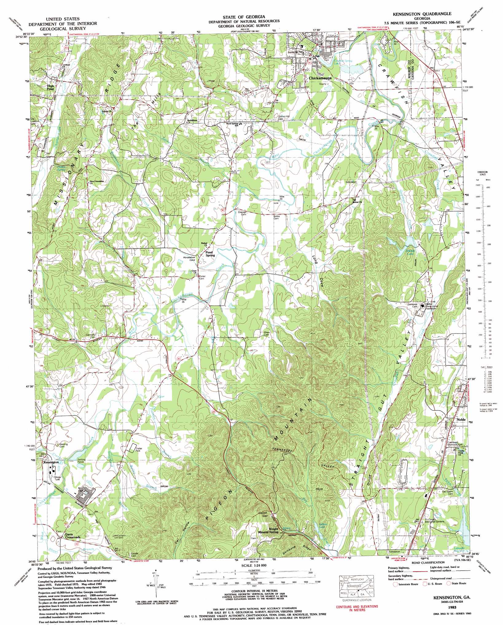
USGS Topo Quad 34085g3 - 1:24,000 scale
| Topo Map Name: | Kensington |
| USGS Topo Quad ID: | 34085g3 |
| Print Size: | ca. 21 1/4" wide x 27" high |
| Southeast Coordinates: | 34.75° N latitude / 85.25° W longitude |
| Map Center Coordinates: | 34.8125° N latitude / 85.3125° W longitude |
| U.S. State: | GA |
| Filename: | o34085g3.jpg |
| Download Map JPG Image: | Kensington topo map 1:24,000 scale |
| Map Type: | Topographic |
| Topo Series: | 7.5´ |
| Map Scale: | 1:24,000 |
| Source of Map Images: | United States Geological Survey (USGS) |
| Alternate Map Versions: |
Kensington GA 1936 Download PDF Buy paper map Kensington GA 1946, updated 1947 Download PDF Buy paper map Kensington GA 1946, updated 1960 Download PDF Buy paper map Kensington GA 1946, updated 1965 Download PDF Buy paper map Kensington GA 1946, updated 1972 Download PDF Buy paper map Kensington GA 1946, updated 1974 Download PDF Buy paper map Kensington GA 1983, updated 1984 Download PDF Buy paper map Kensington GA 2011 Download PDF Buy paper map Kensington GA 2014 Download PDF Buy paper map |
1:24,000 Topo Quads surrounding Kensington
Sequatchie |
Wauhatchie |
Chattanooga |
East Chattanooga |
Ooltewah |
New Home |
Hooker |
Fort Oglethorpe |
East Ridge |
Ringgold |
Trenton |
Durham |
Kensington |
Nickajack Gap |
Tunnel Hill |
Sulphur Springs |
Cedar Grove |
Estelle |
Catlett |
Villanow |
Valley Head |
Dougherty Gap |
Trion |
Subligna |
Sugar Valley |
> Back to 34085e1 at 1:100,000 scale
> Back to 34084a1 at 1:250,000 scale
> Back to U.S. Topo Maps home
Kensington topo map: Gazetteer
Kensington: Bays
Long Cove elevation 230m 754′Kensington: Dams
Barwick Mill Dam One elevation 244m 800′Krystal Lake Dam elevation 221m 725′
Shields Lake Dam elevation 249m 816′
Kensington: Gaps
Catlett Gap elevation 316m 1036′Kensington: Lakes
Crawfish Spring Lake elevation 221m 725′Kensington: Populated Places
Chickamauga elevation 223m 731′Davis Crossroads elevation 253m 830′
Estelle Station (historical) elevation 267m 875′
Hall Mill elevation 240m 787′
High Point elevation 239m 784′
Kendrick (historical) elevation 244m 800′
Kensington elevation 253m 830′
Noble elevation 271m 889′
Pond Spring elevation 233m 764′
Salem (historical) elevation 266m 872′
Warrens (historical) elevation 259m 849′
Kensington: Post Offices
Chickamauga Post Office elevation 225m 738′Kensington: Ranges
The Hills elevation 301m 987′Kensington: Reservoirs
Gilbert Lake elevation 266m 872′Krystal Lake elevation 221m 725′
Shields Lake elevation 249m 816′
Kensington: Springs
Blue Hole elevation 220m 721′Crawfish Spring elevation 220m 721′
Phillips Spring elevation 276m 905′
Kensington: Streams
Bailey Branch elevation 247m 810′Brotherton Creek elevation 230m 754′
Coke Oven Branch elevation 220m 721′
Crawfish Creek elevation 221m 725′
Hall Branch elevation 240m 787′
Jake Goodson Creek elevation 223m 731′
Ketner Branch elevation 230m 754′
Mill Creek elevation 240m 787′
Mill Creek elevation 239m 784′
Pittman Branch elevation 240m 787′
Shaw Branch elevation 250m 820′
Strickland Branch elevation 240m 787′
Kensington: Valleys
Crawfish Valley elevation 220m 721′Owl Hollow elevation 286m 938′
Kensington digital topo map on disk
Buy this Kensington topo map showing relief, roads, GPS coordinates and other geographical features, as a high-resolution digital map file on DVD: