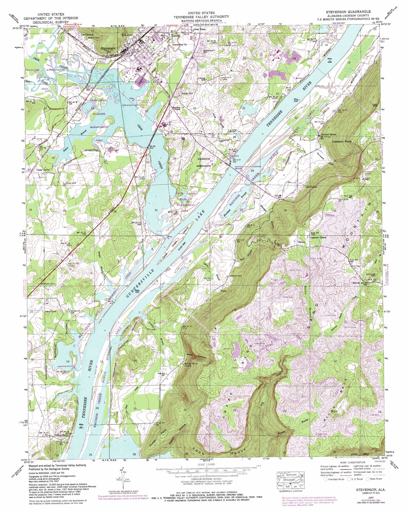
Stevenson Topo Map Alabama
To zoom in, hover over the map of Stevenson
USGS Topo Quad 34085g7 - 1:24,000 scale
| Topo Map Name: | Stevenson |
| USGS Topo Quad ID: | 34085g7 |
| Print Size: | ca. 21 1/4" wide x 27" high |
| Southeast Coordinates: | 34.75° N latitude / 85.75° W longitude |
| Map Center Coordinates: | 34.8125° N latitude / 85.8125° W longitude |
| U.S. State: | AL |
| Filename: | o34085g7.jpg |
| Download Map JPG Image: | Stevenson topo map 1:24,000 scale |
| Map Type: | Topographic |
| Topo Series: | 7.5´ |
| Map Scale: | 1:24,000 |
| Source of Map Images: | United States Geological Survey (USGS) |
| Alternate Map Versions: |
Stevenson AL 1936 Download PDF Buy paper map Stevenson AL 1947, updated 1972 Download PDF Buy paper map Stevenson AL 1947, updated 1984 Download PDF Buy paper map Stevenson AL 1947, updated 1984 Download PDF Buy paper map Stevenson AL 1950 Download PDF Buy paper map Stevenson AL 2011 Download PDF Buy paper map Stevenson AL 2014 Download PDF Buy paper map |
1:24,000 Topo Quads surrounding Stevenson
Pitcher Ridge |
Sinking Cove |
Orme |
South Pittsburg |
Sequatchie |
Hytop |
Eureka |
Doran Cove |
Bridgeport |
New Home |
Mud Creek |
Wannville |
Stevenson |
Flat Rock |
Trenton |
Scottsboro |
Hollywood |
Henagar |
Ider |
Sulphur Springs |
Langston |
Dutton |
Sylvania |
Dugout Valley |
Valley Head |
> Back to 34085e1 at 1:100,000 scale
> Back to 34084a1 at 1:250,000 scale
> Back to U.S. Topo Maps home
Stevenson topo map: Gazetteer
Stevenson: Bars
Coffee Bend Bar elevation 181m 593′Crow Bar elevation 181m 593′
Stevenson: Bends
Craze Bend elevation 406m 1332′Stevenson: Bridges
Captain John Snodgrass Bridge elevation 181m 593′Stevenson: Capes
Coalbank Point elevation 460m 1509′Hunter Point elevation 305m 1000′
Kings Bend elevation 453m 1486′
Stevenson: Crossings
Caperton Ferry elevation 186m 610′Coffeys Ferry elevation 182m 597′
Rudders Ferry (historical) elevation 181m 593′
Stevenson: Islands
Crow Creek Island elevation 183m 600′Stevenson: Parks
Crow Creek Wildlife Management Area elevation 189m 620′Mud Creek Public Shooting Area elevation 181m 593′
Raccoon Creek Public Hunting Area elevation 181m 593′
Stevenson Historic District elevation 192m 629′
Stevenson Municipal Park elevation 185m 606′
Stevenson: Populated Places
Card Switch elevation 196m 643′Cedar Grove elevation 186m 610′
Fabius elevation 438m 1437′
Hymer (historical) elevation 205m 672′
New Town elevation 186m 610′
Old Fabius elevation 205m 672′
Pinder Hill elevation 214m 702′
Stevenson elevation 192m 629′
Yucca elevation 188m 616′
Yucca (historical) elevation 194m 636′
Stevenson: Springs
Norwood Spring elevation 184m 603′Stevenson: Streams
Bengis Creek elevation 181m 593′Brogue Branch elevation 183m 600′
Coon Creek elevation 181m 593′
Crow Creek elevation 181m 593′
Deal Creek elevation 181m 593′
Marshall Branch elevation 181m 593′
Monday Branch elevation 198m 649′
Nichols Branch elevation 181m 593′
Pump Spring Branch elevation 183m 600′
Rocky Branch elevation 401m 1315′
Ross Branch elevation 411m 1348′
Slaton Branch elevation 181m 593′
Sterne Branch elevation 182m 597′
Warren Smith Creek elevation 371m 1217′
Stevenson: Summits
Warren Smith Hill elevation 449m 1473′Stevenson: Valleys
Devils Hollow elevation 201m 659′Mason Hollow elevation 182m 597′
Norwood Cove elevation 184m 603′
Wolf Hollow elevation 194m 636′
Stevenson digital topo map on disk
Buy this Stevenson topo map showing relief, roads, GPS coordinates and other geographical features, as a high-resolution digital map file on DVD: