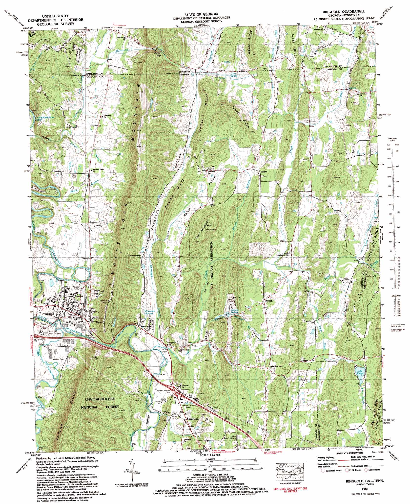
Ringgold Topo Map Georgia
To zoom in, hover over the map of Ringgold
USGS Topo Quad 34085h1 - 1:24,000 scale
| Topo Map Name: | Ringgold |
| USGS Topo Quad ID: | 34085h1 |
| Print Size: | ca. 21 1/4" wide x 27" high |
| Southeast Coordinates: | 34.875° N latitude / 85° W longitude |
| Map Center Coordinates: | 34.9375° N latitude / 85.0625° W longitude |
| U.S. States: | GA, TN |
| Filename: | o34085h1.jpg |
| Download Map JPG Image: | Ringgold topo map 1:24,000 scale |
| Map Type: | Topographic |
| Topo Series: | 7.5´ |
| Map Scale: | 1:24,000 |
| Source of Map Images: | United States Geological Survey (USGS) |
| Alternate Map Versions: |
Ringgold GA 1935 Download PDF Buy paper map Ringgold GA 1946, updated 1947 Download PDF Buy paper map Ringgold GA 1946, updated 1959 Download PDF Buy paper map Ringgold GA 1946, updated 1970 Download PDF Buy paper map Ringgold GA 1946, updated 1971 Download PDF Buy paper map Ringgold GA 1983, updated 1983 Download PDF Buy paper map Ringgold GA 1983, updated 1986 Download PDF Buy paper map Ringgold GA 1983, updated 1988 Download PDF Buy paper map Ringgold GA 2011 Download PDF Buy paper map Ringgold GA 2014 Download PDF Buy paper map |
| FStopo: | US Forest Service topo Ringgold is available: Download FStopo PDF Download FStopo TIF |
1:24,000 Topo Quads surrounding Ringgold
Fairmount |
Daisy |
Snow Hill |
South Cleveland |
East Cleveland |
Chattanooga |
East Chattanooga |
Ooltewah |
Mcdonald |
Felker |
Fort Oglethorpe |
East Ridge |
Ringgold |
Cohutta |
Beaverdale |
Kensington |
Nickajack Gap |
Tunnel Hill |
Dalton North |
Chatsworth |
Estelle |
Catlett |
Villanow |
Dalton South |
Calhoun Ne |
> Back to 34085e1 at 1:100,000 scale
> Back to 34084a1 at 1:250,000 scale
> Back to U.S. Topo Maps home
Ringgold topo map: Gazetteer
Ringgold: Airports
Catoosa Springs Stolport elevation 271m 889′Ringgold: Basins
Cherokee Valley elevation 283m 928′Salem Valley elevation 259m 849′
Ringgold: Crossings
Interchange 139 elevation 245m 803′Ringgold: Dams
Lake Kathy Dam elevation 274m 898′Ringgold: Gaps
Parker Gap elevation 248m 813′Ringgold: Parks
Joseph Standing Monument elevation 279m 915′Ringgold: Populated Places
Catoosa Springs elevation 247m 810′Greenwood elevation 250m 820′
Keith elevation 271m 889′
Kesler Hills elevation 268m 879′
Mount Vernon elevation 277m 908′
Ringgold elevation 237m 777′
Salem elevation 265m 869′
Shookville elevation 236m 774′
Stone Church elevation 236m 774′
Sugartown elevation 255m 836′
Ringgold: Post Offices
Catoosa Springs Post Office (historical) elevation 247m 810′Ringgold: Reservoirs
Lake Kathy elevation 274m 898′Ringgold: Ridges
Baker Ridge elevation 332m 1089′Baker Ridge elevation 339m 1112′
Cedar Bluff elevation 357m 1171′
Cohutta Ridge elevation 303m 994′
Conley Bluff elevation 341m 1118′
Conley Bluff elevation 267m 875′
Toney Ridge elevation 324m 1062′
Ringgold: Springs
Catoosa Springs elevation 248m 813′Cave Spring elevation 257m 843′
Cherokee Springs elevation 244m 800′
Ringgold: Streams
Broom Branch elevation 236m 774′Cat Creek elevation 259m 849′
Catoosa Springs Branch elevation 233m 764′
Cherokee Branch elevation 234m 767′
East Chickamauga Creek elevation 231m 757′
Johnson Branch elevation 250m 820′
Johnson Branch elevation 250m 820′
Kettle Branch elevation 215m 705′
Little Chickamauga Creek elevation 225m 738′
Little Creek elevation 253m 830′
Little Tiger Creek elevation 248m 813′
Peters Branch elevation 218m 715′
Sugar Creek elevation 241m 790′
Sugar Creek elevation 241m 790′
Tiger Creek elevation 232m 761′
Ward Branch elevation 259m 849′
Ringgold: Summits
Sand Mountain elevation 405m 1328′White Oak Mountain elevation 341m 1118′
White Oak Mountain elevation 373m 1223′
Ringgold: Valleys
Keith Valley elevation 298m 977′Mount Vernon Valley elevation 253m 830′
Rabbit Valley elevation 226m 741′
Rabbit Valley elevation 232m 761′
Rhinehart Valley elevation 256m 839′
Rhinehart Valley elevation 254m 833′
Ringgold digital topo map on disk
Buy this Ringgold topo map showing relief, roads, GPS coordinates and other geographical features, as a high-resolution digital map file on DVD: