East Ridge Topo Map Georgia
To zoom in, hover over the map of East Ridge
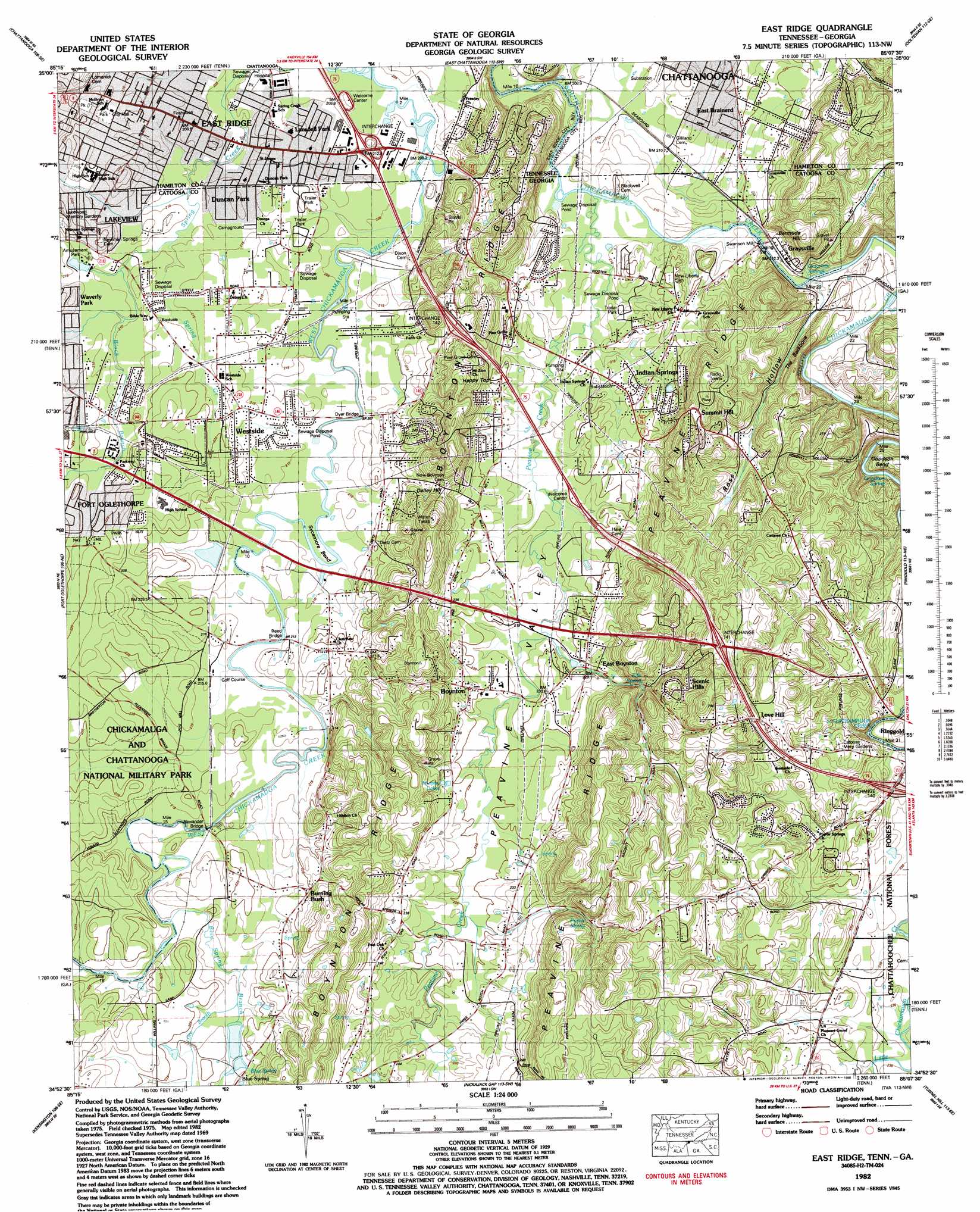
USGS Topo Quad 34085h2 - 1:24,000 scale
| Topo Map Name: | East Ridge |
| USGS Topo Quad ID: | 34085h2 |
| Print Size: | ca. 21 1/4" wide x 27" high |
| Southeast Coordinates: | 34.875° N latitude / 85.125° W longitude |
| Map Center Coordinates: | 34.9375° N latitude / 85.1875° W longitude |
| U.S. States: | GA, TN |
| Filename: | o34085h2.jpg |
| Download Map JPG Image: | East Ridge topo map 1:24,000 scale |
| Map Type: | Topographic |
| Topo Series: | 7.5´ |
| Map Scale: | 1:24,000 |
| Source of Map Images: | United States Geological Survey (USGS) |
| Alternate Map Versions: |
East Ridge TN 1935 Download PDF Buy paper map East Ridge TN 1943, updated 1957 Download PDF Buy paper map East Ridge TN 1946, updated 1947 Download PDF Buy paper map East Ridge TN 1958, updated 1959 Download PDF Buy paper map East Ridge TN 1958, updated 1967 Download PDF Buy paper map East Ridge TN 1969, updated 1970 Download PDF Buy paper map East Ridge TN 1969, updated 1975 Download PDF Buy paper map East Ridge TN 1982, updated 1983 Download PDF Buy paper map East Ridge TN 1982, updated 1988 Download PDF Buy paper map East Ridge TN 2011 Download PDF Buy paper map East Ridge TN 2013 Download PDF Buy paper map East Ridge TN 2016 Download PDF Buy paper map |
| FStopo: | US Forest Service topo East Ridge is available: Download FStopo PDF Download FStopo TIF |
1:24,000 Topo Quads surrounding East Ridge
Ketner Gap |
Fairmount |
Daisy |
Snow Hill |
South Cleveland |
Wauhatchie |
Chattanooga |
East Chattanooga |
Ooltewah |
Mcdonald |
Hooker |
Fort Oglethorpe |
East Ridge |
Ringgold |
Cohutta |
Durham |
Kensington |
Nickajack Gap |
Tunnel Hill |
Dalton North |
Cedar Grove |
Estelle |
Catlett |
Villanow |
Dalton South |
> Back to 34085e1 at 1:100,000 scale
> Back to 34084a1 at 1:250,000 scale
> Back to U.S. Topo Maps home
East Ridge topo map: Gazetteer
East Ridge: Areas
Brook Field elevation 226m 741′East Ridge: Basins
Dry Pond elevation 259m 849′East Ridge: Bends
Goodson Bend elevation 236m 774′Sycamore Bend elevation 206m 675′
East Ridge: Bridges
Alexander Bridge elevation 210m 688′Dyer Bridge elevation 206m 675′
Dyers Bridge (historical) elevation 206m 675′
Reed Bridge elevation 210m 688′
Ringgold Bridge (historical) elevation 205m 672′
East Ridge: Crossings
Byrams Ford elevation 210m 688′Daffron Ford elevation 205m 672′
Dalton Ford elevation 214m 702′
Dyers Ford elevation 208m 682′
Fowlers Ford elevation 209m 685′
Interchange 1 elevation 209m 685′
Interchange 140 elevation 239m 784′
Interchange 141 elevation 289m 948′
Interchange 142 elevation 242m 793′
Lamberts Ford elevation 209m 685′
Reeds Ford elevation 208m 682′
Reeds Ford elevation 209m 685′
Thedford Ford elevation 212m 695′
East Ridge: Dams
Blue Spring Lake Dam elevation 219m 718′East Ridge: Parks
Baldwin Monument elevation 225m 738′Elise Chapin Wildlife Sanctuary elevation 203m 666′
Helm Monument elevation 225m 738′
Smith Monument elevation 222m 728′
East Ridge: Populated Places
Belvoir Terrace elevation 214m 702′Blevins Acre elevation 224m 734′
Blue Spring elevation 220m 721′
Boyd Highlands elevation 266m 872′
Boynton elevation 236m 774′
Brookvale Estates elevation 212m 695′
Burning Bush elevation 224m 734′
Castle Park elevation 215m 705′
Cinderella Hills elevation 234m 767′
Dafron elevation 212m 695′
Dallondale elevation 219m 718′
Dietz elevation 221m 725′
East Boynton elevation 224m 734′
East Brainerd elevation 224m 734′
Ellie Spring elevation 235m 770′
Foster Hills elevation 226m 741′
Graysville elevation 214m 702′
Harris Hills elevation 237m 777′
Harris Hills elevation 276m 905′
Indian Springs elevation 219m 718′
Irwin Hills elevation 225m 738′
Lansdell Park elevation 212m 695′
Liles Addition elevation 221m 725′
Love Hill elevation 279m 915′
Mana Estates elevation 219m 718′
McDonald Acres elevation 217m 711′
Mitchell Acres elevation 220m 721′
Morris Estates elevation 216m 708′
New Liberty elevation 227m 744′
Newnan Springs elevation 216m 708′
Old Fort Estates elevation 236m 774′
Old Mill Trace elevation 219m 718′
Opeleika (historical) elevation 213m 698′
Pleasant Grove elevation 242m 793′
Poplar Springs elevation 246m 807′
Post Oak elevation 237m 777′
Scenic Hills elevation 281m 921′
Summit Hill elevation 274m 898′
Swanson Mill elevation 211m 692′
Walnut Hills elevation 207m 679′
Waverly Park elevation 220m 721′
Westside elevation 217m 711′
East Ridge: Reservoirs
Blue Spring Lake elevation 219m 718′Lake Winnepesauka elevation 212m 695′
Murphy Lakes elevation 228m 748′
East Ridge: Ridges
The Backbone elevation 263m 862′East Ridge: Springs
Blue Spring elevation 220m 721′Ellis Spring elevation 234m 767′
Goodson Spring elevation 225m 738′
Graysville Springs elevation 209m 685′
Poplar Spring elevation 257m 843′
Sweet Spring elevation 219m 718′
Wild Cat Spring elevation 222m 728′
East Ridge: Streams
Black Branch elevation 207m 679′Blue Spring Branch elevation 212m 695′
Dry Branch elevation 217m 711′
Hurricane Branch elevation 207m 679′
Hurricane Creek elevation 209m 685′
Mackey Branch elevation 205m 672′
Peavine Creek elevation 207m 679′
East Ridge: Summits
Bermuda Hill elevation 300m 984′Boynton Ridge elevation 271m 889′
Dailey Hill elevation 253m 830′
Happy Top elevation 280m 918′
East Ridge: Valleys
Peavine Valley elevation 207m 679′Ross Hollow elevation 210m 688′
East Ridge digital topo map on disk
Buy this East Ridge topo map showing relief, roads, GPS coordinates and other geographical features, as a high-resolution digital map file on DVD: