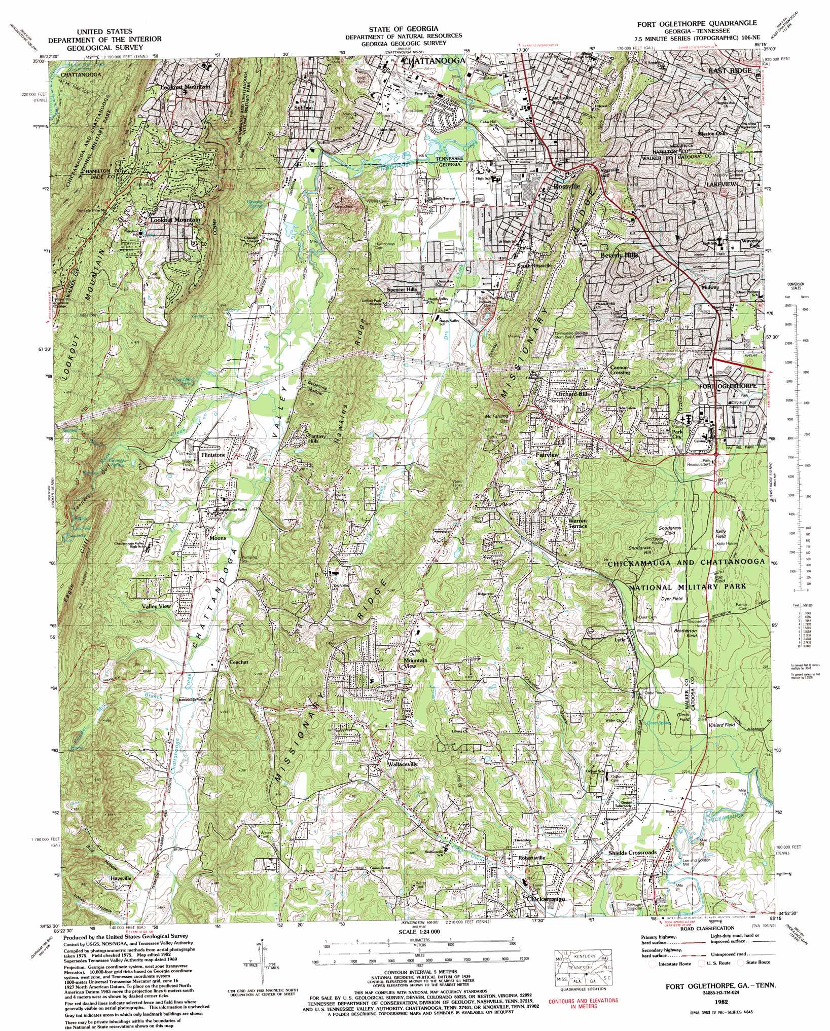
Fort Oglethorpe Topo Map Georgia
To zoom in, hover over the map of Fort Oglethorpe
USGS Topo Quad 34085h3 - 1:24,000 scale
| Topo Map Name: | Fort Oglethorpe |
| USGS Topo Quad ID: | 34085h3 |
| Print Size: | ca. 21 1/4" wide x 27" high |
| Southeast Coordinates: | 34.875° N latitude / 85.25° W longitude |
| Map Center Coordinates: | 34.9375° N latitude / 85.3125° W longitude |
| U.S. States: | GA, TN |
| Filename: | o34085h3.jpg |
| Download Map JPG Image: | Fort Oglethorpe topo map 1:24,000 scale |
| Map Type: | Topographic |
| Topo Series: | 7.5´ |
| Map Scale: | 1:24,000 |
| Source of Map Images: | United States Geological Survey (USGS) |
| Alternate Map Versions: |
Fort Oglethorpe GA 1936 Download PDF Buy paper map Fort Oglethorpe GA 1942, updated 1946 Download PDF Buy paper map Fort Oglethorpe GA 1942, updated 1957 Download PDF Buy paper map Fort Oglethorpe GA 1958, updated 1959 Download PDF Buy paper map Fort Oglethorpe GA 1958, updated 1965 Download PDF Buy paper map Fort Oglethorpe GA 1969, updated 1970 Download PDF Buy paper map Fort Oglethorpe GA 1982, updated 1983 Download PDF Buy paper map Fort Oglethorpe GA 1982, updated 1988 Download PDF Buy paper map Fort Oglethorpe GA 1982, updated 1988 Download PDF Buy paper map Fort Oglethorpe GA 2010 Download PDF Buy paper map Fort Oglethorpe GA 2014 Download PDF Buy paper map |
1:24,000 Topo Quads surrounding Fort Oglethorpe
Whitwell |
Ketner Gap |
Fairmount |
Daisy |
Snow Hill |
Sequatchie |
Wauhatchie |
Chattanooga |
East Chattanooga |
Ooltewah |
New Home |
Hooker |
Fort Oglethorpe |
East Ridge |
Ringgold |
Trenton |
Durham |
Kensington |
Nickajack Gap |
Tunnel Hill |
Sulphur Springs |
Cedar Grove |
Estelle |
Catlett |
Villanow |
> Back to 34085e1 at 1:100,000 scale
> Back to 34084a1 at 1:250,000 scale
> Back to U.S. Topo Maps home
Fort Oglethorpe topo map: Gazetteer
Fort Oglethorpe: Areas
Brotherton Field elevation 226m 741′Glenn Field elevation 220m 721′
Fort Oglethorpe: Cliffs
Eagle Cliff elevation 450m 1476′Fort Oglethorpe: Crossings
Halls Ford elevation 215m 705′Fort Oglethorpe: Falls
Lula Falls elevation 378m 1240′Fort Oglethorpe: Gaps
McFarland Gap elevation 254m 833′Rossville Gap elevation 233m 764′
Fort Oglethorpe: Lakes
Bloody Pond (historical) elevation 229m 751′Lula Lake elevation 387m 1269′
McCallie Lake elevation 234m 767′
Fort Oglethorpe: Parks
Alabama Monument elevation 240m 787′Bushrod R Johnson Monument elevation 233m 764′
Chickamauga and Chattanooga National Military Park elevation 336m 1102′
Chickamauga and Chattanooga National Military Park elevation 231m 757′
Colquitt Monument elevation 225m 738′
Deshier Monument elevation 237m 777′
Florids Monument elevation 225m 738′
Georgia Monument elevation 235m 770′
Heg Monument elevation 219m 718′
Kentucky Monument elevation 228m 748′
King Monument elevation 235m 770′
Lytle Monument elevation 228m 748′
Rossville Recreational Area elevation 206m 675′
South Carolina Monument elevation 256m 839′
Texas Monument elevation 236m 774′
Wilder Monument elevation 231m 757′
Fort Oglethorpe: Pillars
Wilder Tower elevation 231m 757′Fort Oglethorpe: Populated Places
Beverly Hills elevation 258m 846′Blowing Spring elevation 211m 692′
Cannon Crossing elevation 255m 836′
Cedar Hill elevation 224m 734′
Cenchat elevation 218m 715′
Chattanooga Valley elevation 227m 744′
Cloud Springs elevation 221m 725′
Dewberry Town elevation 260m 853′
Dickey (historical) elevation 207m 679′
Eagle Cliff elevation 223m 731′
Fairlawn Acres elevation 221m 725′
Fairview elevation 259m 849′
Fantasy Hills elevation 259m 849′
Flintstone elevation 212m 695′
Fort Oglethorpe elevation 223m 731′
Georgia Acres elevation 283m 928′
Gerber (historical) elevation 380m 1246′
Green Acres elevation 217m 711′
Green Hills elevation 272m 892′
Happy Valley elevation 248m 813′
Haysville elevation 238m 780′
John Ross Estates elevation 279m 915′
Lakeview elevation 234m 767′
Laurelwood Estates elevation 296m 971′
Lookout Mountain elevation 549m 1801′
Lookout Mountain elevation 564m 1850′
Lytle elevation 235m 770′
Midway elevation 229m 751′
Milbro Heights elevation 275m 902′
Mission Oaks elevation 230m 754′
Moons elevation 212m 695′
Mountain View elevation 316m 1036′
Orchard Hills elevation 288m 944′
Park City elevation 243m 797′
Pinewood Estates elevation 219m 718′
Piney Woods elevation 209m 685′
Red Belt elevation 222m 728′
Robertsville elevation 231m 757′
Rock City elevation 500m 1640′
Rossville elevation 213m 698′
Saint Elmo elevation 221m 725′
Shadynook elevation 274m 898′
South Rossville elevation 210m 688′
Spencer Hills elevation 208m 682′
Valley View elevation 219m 718′
Wallaceville elevation 261m 856′
Warren Terrace elevation 286m 938′
White Oak elevation 255m 836′
Woodland Hills elevation 202m 662′
Fort Oglethorpe: Post Offices
East Ridge Post Office elevation 244m 800′Lookout Mountain Post Office elevation 579m 1899′
Lytle Post Office (historical) elevation 235m 770′
Rossville Post Office elevation 212m 695′
Fort Oglethorpe: Ridges
Hawkins Ridge elevation 301m 987′Missionary Ridge elevation 284m 931′
Missionary Ridge elevation 324m 1062′
Fort Oglethorpe: Springs
Blowing Spring elevation 207m 679′Cave Spring elevation 225m 738′
Crutchfield Spring elevation 210m 688′
Knight Spring elevation 251m 823′
Tannery Spring elevation 256m 839′
Williams Spring elevation 219m 718′
Fort Oglethorpe: Streams
Big Spring Branch elevation 222m 728′Dry Creek elevation 198m 649′
Long Branch elevation 394m 1292′
Powder Mill Branch elevation 215m 705′
Rock Creek elevation 205m 672′
Sawmill Branch elevation 239m 784′
Fort Oglethorpe: Summits
Snodgrass Hill elevation 273m 895′Fort Oglethorpe: Trails
Bluff Trail elevation 572m 1876′Fort Oglethorpe: Valleys
Bird Hollow elevation 231m 757′Chandler Hollow elevation 233m 764′
Dynamite Hollow elevation 210m 688′
Ironco Hollow elevation 238m 780′
Long Hollow elevation 227m 744′
Lookout Valley elevation 197m 646′
Tannery Gulf elevation 231m 757′
Fort Oglethorpe digital topo map on disk
Buy this Fort Oglethorpe topo map showing relief, roads, GPS coordinates and other geographical features, as a high-resolution digital map file on DVD: