New Home Topo Map Georgia
To zoom in, hover over the map of New Home
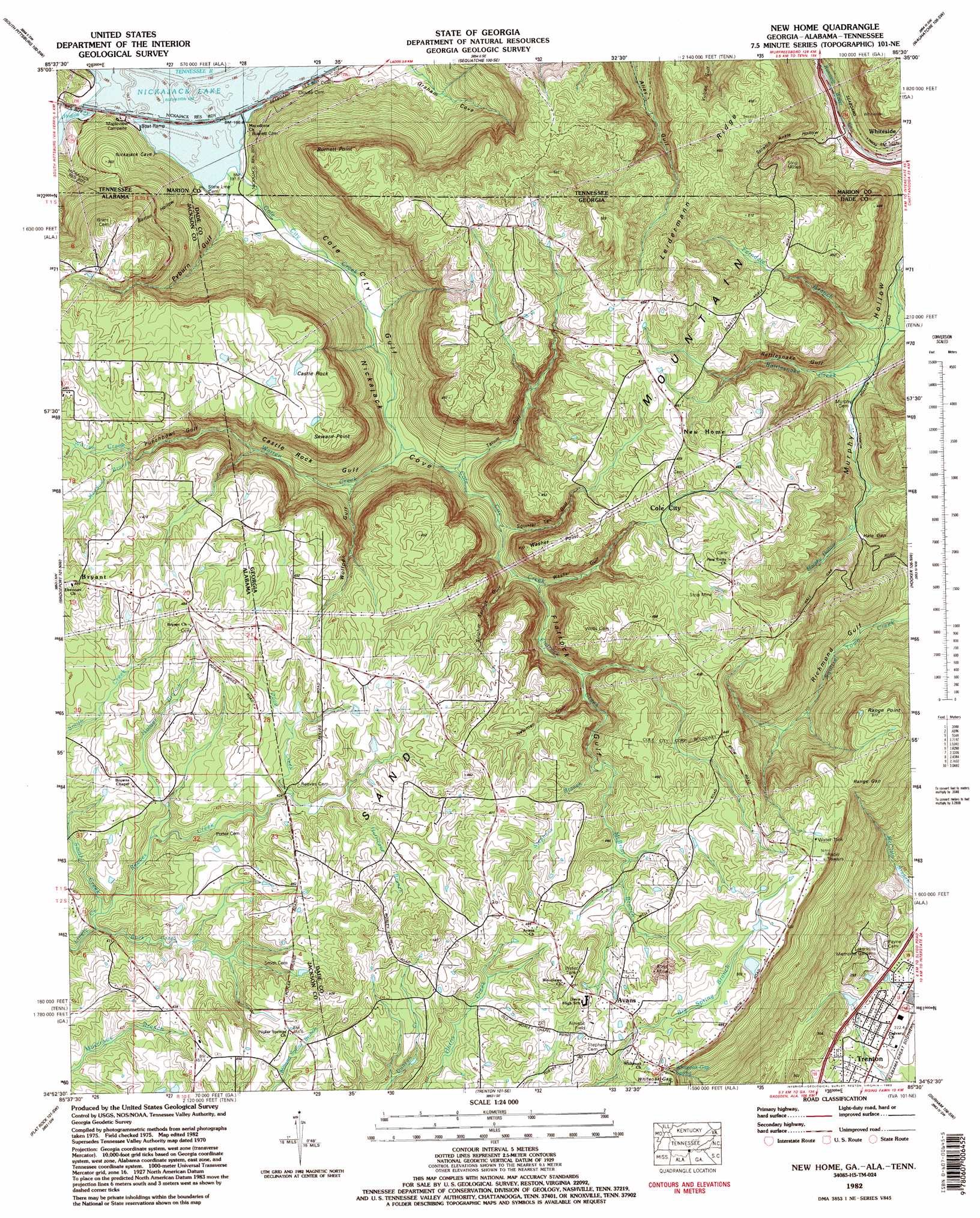
USGS Topo Quad 34085h5 - 1:24,000 scale
| Topo Map Name: | New Home |
| USGS Topo Quad ID: | 34085h5 |
| Print Size: | ca. 21 1/4" wide x 27" high |
| Southeast Coordinates: | 34.875° N latitude / 85.5° W longitude |
| Map Center Coordinates: | 34.9375° N latitude / 85.5625° W longitude |
| U.S. States: | GA, AL, TN |
| Filename: | o34085h5.jpg |
| Download Map JPG Image: | New Home topo map 1:24,000 scale |
| Map Type: | Topographic |
| Topo Series: | 7.5´ |
| Map Scale: | 1:24,000 |
| Source of Map Images: | United States Geological Survey (USGS) |
| Alternate Map Versions: |
Shellmound GA 1936 Download PDF Buy paper map Shellmound GA 1945 Download PDF Buy paper map Shellmound GA 1945, updated 1966 Download PDF Buy paper map Shellmound GA 1946, updated 1947 Download PDF Buy paper map New Home GA 1970, updated 1977 Download PDF Buy paper map New Home GA 1982, updated 1983 Download PDF Buy paper map New Home GA 1982, updated 1983 Download PDF Buy paper map New Home GA 2010 Download PDF Buy paper map New Home GA 2014 Download PDF Buy paper map |
1:24,000 Topo Quads surrounding New Home
Monteagle |
White City |
Whitwell |
Ketner Gap |
Fairmount |
Orme |
South Pittsburg |
Sequatchie |
Wauhatchie |
Chattanooga |
Doran Cove |
Bridgeport |
New Home |
Hooker |
Fort Oglethorpe |
Stevenson |
Flat Rock |
Trenton |
Durham |
Kensington |
Henagar |
Ider |
Sulphur Springs |
Cedar Grove |
Estelle |
> Back to 34085e1 at 1:100,000 scale
> Back to 34084a1 at 1:250,000 scale
> Back to U.S. Topo Maps home
New Home topo map: Gazetteer
New Home: Bays
Castle Rock Gulf elevation 247m 810′Newman Gulf elevation 348m 1141′
Sulphur Springs Gulf elevation 302m 990′
Tatum Gulf elevation 270m 885′
Washer Gulf elevation 298m 977′
Wolfpen Gulf elevation 265m 869′
New Home: Capes
Burnett Point elevation 482m 1581′New Home: Cliffs
Range Point elevation 504m 1653′Seward Point elevation 435m 1427′
New Home: Dams
Dyer Lake Dam elevation 248m 813′Lake Hills Estates Dam elevation 243m 797′
New Home: Gaps
Hale Gap elevation 333m 1092′Range Gap elevation 480m 1574′
Whiteoak Gap elevation 462m 1515′
New Home: Mines
Bailey Mine elevation 455m 1492′Castle Rock Mine elevation 430m 1410′
Cole City Mine elevation 431m 1414′
Dade Mine elevation 413m 1354′
Davis-Wells Mine elevation 434m 1423′
Ferndale Mine elevation 418m 1371′
Green Mine elevation 455m 1492′
Holland Mine elevation 352m 1154′
Mars Mine elevation 403m 1322′
Murphy Mine elevation 404m 1325′
New England Mine elevation 422m 1384′
New South Mine elevation 432m 1417′
Parker Mine elevation 429m 1407′
Pat Obrien Mine elevation 453m 1486′
Racoon Mine elevation 432m 1417′
Rattlesnake Mine elevation 396m 1299′
Tatum Gulf Mine elevation 426m 1397′
New Home: Parks
Maple View Public Use Area elevation 194m 636′New Home: Populated Places
Avans elevation 479m 1571′Cole City elevation 267m 875′
Nickajack (historical) elevation 193m 633′
Shellmound (historical) elevation 193m 633′
New Home: Ranges
Sand Mountain elevation 449m 1473′New Home: Reservoirs
Dyer Lake elevation 248m 813′Getter Lake elevation 243m 797′
New Home: Ridges
Leidermann Ridge elevation 454m 1489′Leidermann Ridge elevation 476m 1561′
New Home: Springs
Murphy Spring elevation 303m 994′White Spring elevation 248m 813′
Whiteoak Gap Spring elevation 478m 1568′
New Home: Streams
Buck Creek elevation 391m 1282′Cole City Creek elevation 194m 636′
Cole City Creek elevation 194m 636′
Dove Creek elevation 420m 1377′
Dove Creek elevation 419m 1374′
Ferndale Branch elevation 266m 872′
Flatrock Creek elevation 298m 977′
Hogjaw Creek elevation 193m 633′
Hogjaw Creek elevation 193m 633′
Holder Branch elevation 396m 1299′
Hurricane Branch elevation 419m 1374′
McBriar Branch elevation 399m 1309′
Meadows Branch elevation 421m 1381′
Rattlesnake Creek elevation 270m 885′
Reeves Creek elevation 389m 1276′
Reeves Creek elevation 387m 1269′
Smith Creek elevation 387m 1269′
Stephens Branch elevation 399m 1309′
Warren Creek elevation 243m 797′
Warren Creek elevation 244m 800′
New Home: Summits
Castle Rock elevation 420m 1377′Sand Mountain elevation 449m 1473′
New Home: Valleys
Barton Hollow elevation 199m 652′Barton Hollow elevation 202m 662′
Castle Rock Gulf elevation 246m 807′
Nickajack Cove elevation 194m 636′
Punchbowl Gulf elevation 335m 1099′
Pyburn Gulf elevation 213m 698′
Pyburn Gulf elevation 219m 718′
Rattlesnake Gulf elevation 288m 944′
Richmond Gulf elevation 242m 793′
Scratch Ankle Hollow elevation 247m 810′
Squirrel Tail Gulf elevation 283m 928′
New Home digital topo map on disk
Buy this New Home topo map showing relief, roads, GPS coordinates and other geographical features, as a high-resolution digital map file on DVD: