Howelton Topo Map Alabama
To zoom in, hover over the map of Howelton
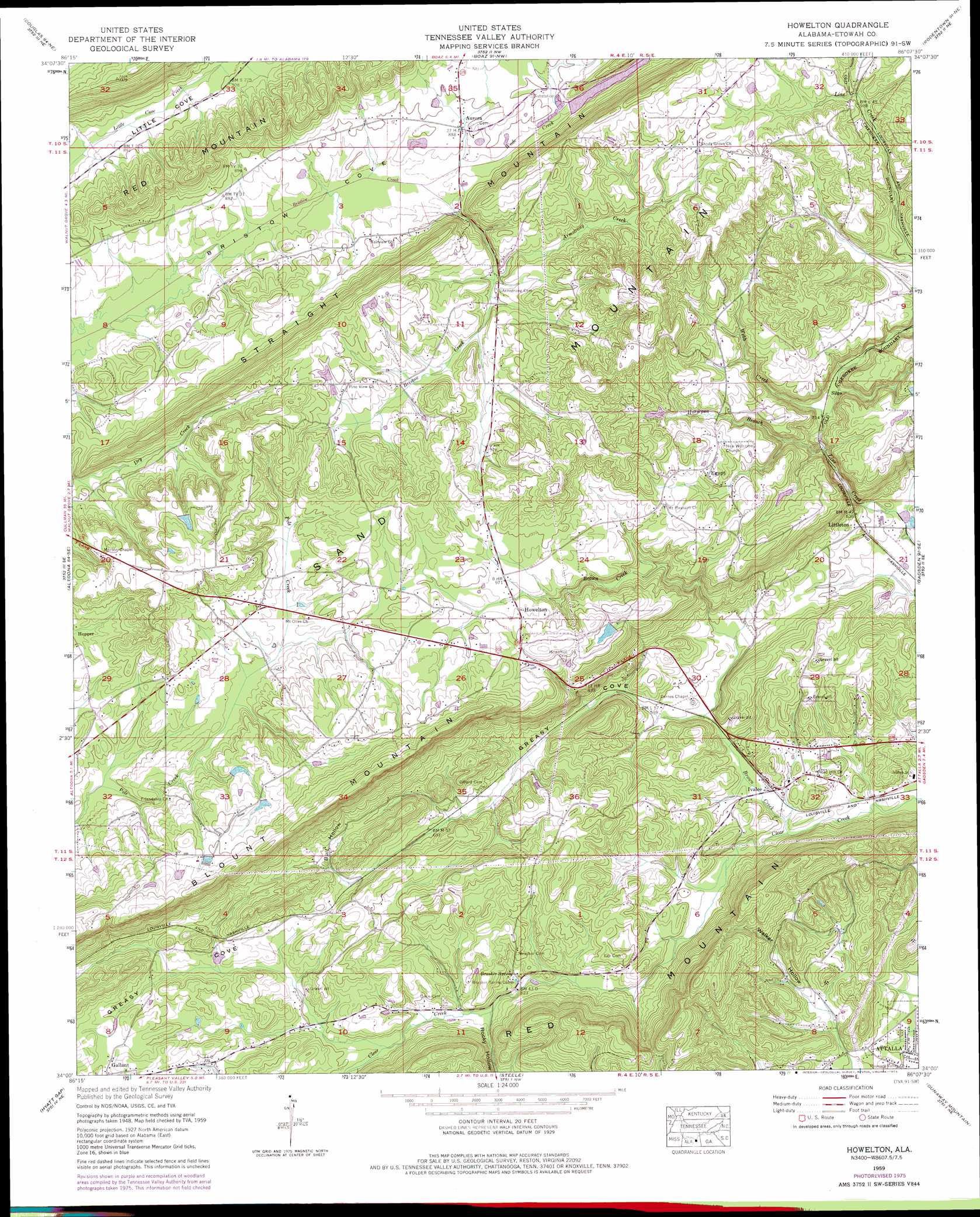
USGS Topo Quad 34086a2 - 1:24,000 scale
| Topo Map Name: | Howelton |
| USGS Topo Quad ID: | 34086a2 |
| Print Size: | ca. 21 1/4" wide x 27" high |
| Southeast Coordinates: | 34° N latitude / 86.125° W longitude |
| Map Center Coordinates: | 34.0625° N latitude / 86.1875° W longitude |
| U.S. State: | AL |
| Filename: | o34086a2.jpg |
| Download Map JPG Image: | Howelton topo map 1:24,000 scale |
| Map Type: | Topographic |
| Topo Series: | 7.5´ |
| Map Scale: | 1:24,000 |
| Source of Map Images: | United States Geological Survey (USGS) |
| Alternate Map Versions: |
Howelton AL 1959, updated 1961 Download PDF Buy paper map Howelton AL 1959, updated 1976 Download PDF Buy paper map Howelton AL 2011 Download PDF Buy paper map Howelton AL 2014 Download PDF Buy paper map |
1:24,000 Topo Quads surrounding Howelton
Arab |
Guntersville |
Albertville |
Painter |
Crossville |
Brooksville |
Douglas |
Boaz |
Rodentown |
Keener |
Clarence |
Altoona |
Howelton |
Gadsden West |
Gadsden East |
Oneonta |
Hyatt Gap |
Steele |
Dunaway Mountain |
Glencoe |
Springville |
Ashville |
Cox Gap |
Ohatchee |
Wellington |
> Back to 34086a1 at 1:100,000 scale
> Back to 34086a1 at 1:250,000 scale
> Back to U.S. Topo Maps home
Howelton topo map: Gazetteer
Howelton: Dams
Bristows Creek Watershed Dam Number 1 elevation 273m 895′Glassco Lake Dam elevation 298m 977′
Howelton: Gaps
Gregory Gap elevation 265m 869′Sheffield Gap elevation 192m 629′
Howelton: Populated Places
Aurora elevation 270m 885′Benson (historical) elevation 182m 597′
Egypt elevation 288m 944′
Harrisville elevation 304m 997′
Howelton elevation 302m 990′
Ivalee elevation 180m 590′
Littleton elevation 190m 623′
Mays elevation 275m 902′
Pleasant Valley elevation 180m 590′
Shady Grove elevation 332m 1089′
Stanfield (historical) elevation 203m 666′
Howelton: Reservoirs
Aurora Lake elevation 275m 902′Aurora Recreational Lake elevation 273m 895′
Glassco Lake elevation 298m 977′
Howelton: Springs
Brasher Spring elevation 194m 636′Shahan Spring elevation 176m 577′
Howelton: Streams
Armstrong Creek elevation 273m 895′Brown Creek elevation 169m 554′
Horsepen Branch elevation 208m 682′
Pole Creek elevation 262m 859′
Wade Creek elevation 264m 866′
Webb Creek elevation 219m 718′
Howelton: Summits
Walker Mountain elevation 367m 1204′Howelton: Valleys
Bull Hollow elevation 226m 741′Greasy Cove elevation 179m 587′
Lemon Hollow elevation 205m 672′
Rocky Hollow elevation 195m 639′
Walker Hollow elevation 183m 600′
Howelton digital topo map on disk
Buy this Howelton topo map showing relief, roads, GPS coordinates and other geographical features, as a high-resolution digital map file on DVD: