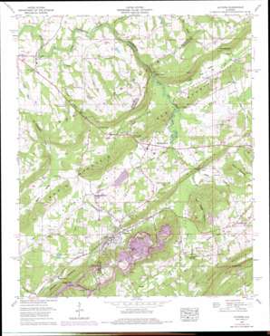
Altoona Topo Map Alabama
To zoom in, hover over the map of Altoona
USGS Topo Quad 34086a3 - 1:24,000 scale
| Topo Map Name: | Altoona |
| USGS Topo Quad ID: | 34086a3 |
| Print Size: | ca. 21 1/4" wide x 27" high |
| Southeast Coordinates: | 34° N latitude / 86.25° W longitude |
| Map Center Coordinates: | 34.0625° N latitude / 86.3125° W longitude |
| U.S. State: | AL |
| Filename: | o34086a3.jpg |
| Download Map JPG Image: | Altoona topo map 1:24,000 scale |
| Map Type: | Topographic |
| Topo Series: | 7.5´ |
| Map Scale: | 1:24,000 |
| Source of Map Images: | United States Geological Survey (USGS) |
| Alternate Map Versions: |
Altoona AL 1958, updated 1960 Download PDF Buy paper map Altoona AL 1958, updated 1976 Download PDF Buy paper map Altoona AL 1958, updated 1986 Download PDF Buy paper map Altoona AL 1975, updated 1977 Download PDF Buy paper map Altoona AL 1975, updated 1983 Download PDF Buy paper map Altoona AL 2011 Download PDF Buy paper map Altoona AL 2014 Download PDF Buy paper map |
1:24,000 Topo Quads surrounding Altoona
> Back to 34086a1 at 1:100,000 scale
> Back to 34086a1 at 1:250,000 scale
> Back to U.S. Topo Maps home
Altoona topo map: Gazetteer
Altoona: Bridges
Thompson Bridge elevation 250m 820′Altoona: Dams
Jenkins Number One Dam elevation 271m 889′Jenkins Number Three Dam elevation 265m 869′
Jenkins Number Two Dam elevation 275m 902′
Ruell Snead Dam Number One elevation 269m 882′
Ruell Snead Dam Number Two elevation 278m 912′
Altoona: Gaps
Crooked Gap elevation 377m 1236′Drury Bynum Gap elevation 280m 918′
Maynor Gap elevation 266m 872′
Nelson Gap elevation 253m 830′
Nix Gap elevation 253m 830′
Silver Gap elevation 285m 935′
Tanyard Gap elevation 285m 935′
Tumlin Gap elevation 382m 1253′
Altoona: Lakes
Hanna Pond elevation 291m 954′Altoona: Mines
Altoona Coal Mines elevation 344m 1128′Parker Mine elevation 279m 915′
Altoona: Populated Places
Altoona elevation 289m 948′Boxtel elevation 275m 902′
Clayborn elevation 262m 859′
Ellison Crossroads elevation 263m 862′
Hopper elevation 281m 921′
New Home elevation 268m 879′
Old Snead elevation 245m 803′
Pana elevation 259m 849′
Phillips (historical) elevation 280m 918′
Pine Grove elevation 262m 859′
Redbud elevation 279m 915′
Schuler (historical) elevation 269m 882′
Walnut Grove elevation 262m 859′
Altoona: Reservoirs
Doctor Jenkins Lake elevation 265m 869′Jenkins Number One Lake elevation 271m 889′
Jenkins Number Two Lake elevation 275m 902′
Snead Lake One elevation 269m 882′
Snead Lake Two elevation 278m 912′
Altoona: Ridges
Altoona Mountain elevation 397m 1302′Straight Mountain elevation 355m 1164′
Altoona: Springs
Cove Spring elevation 260m 853′Maynor Spring elevation 267m 875′
Altoona: Streams
Bristow Creek elevation 247m 810′Clear Creek elevation 235m 770′
Dry Creek elevation 253m 830′
Kenchelow Creek elevation 230m 754′
Little Cove Creek elevation 246m 807′
Mining Pond Branch elevation 255m 836′
Payne Branch elevation 250m 820′
Phillips Branch elevation 246m 807′
Robbins Branch elevation 250m 820′
Samuels Chapel Creek elevation 255m 836′
Tanyard Branch elevation 236m 774′
Altoona: Summits
Elrod Mountain elevation 335m 1099′Sam Hopper Mountain elevation 346m 1135′
Altoona: Valleys
Bristow Cove elevation 248m 813′Little Cove elevation 247m 810′
Van Zandt Hollow elevation 267m 875′
Warrior Valley elevation 253m 830′
Altoona digital topo map on disk
Buy this Altoona topo map showing relief, roads, GPS coordinates and other geographical features, as a high-resolution digital map file on DVD:


