Guntersville Topo Map Alabama
To zoom in, hover over the map of Guntersville
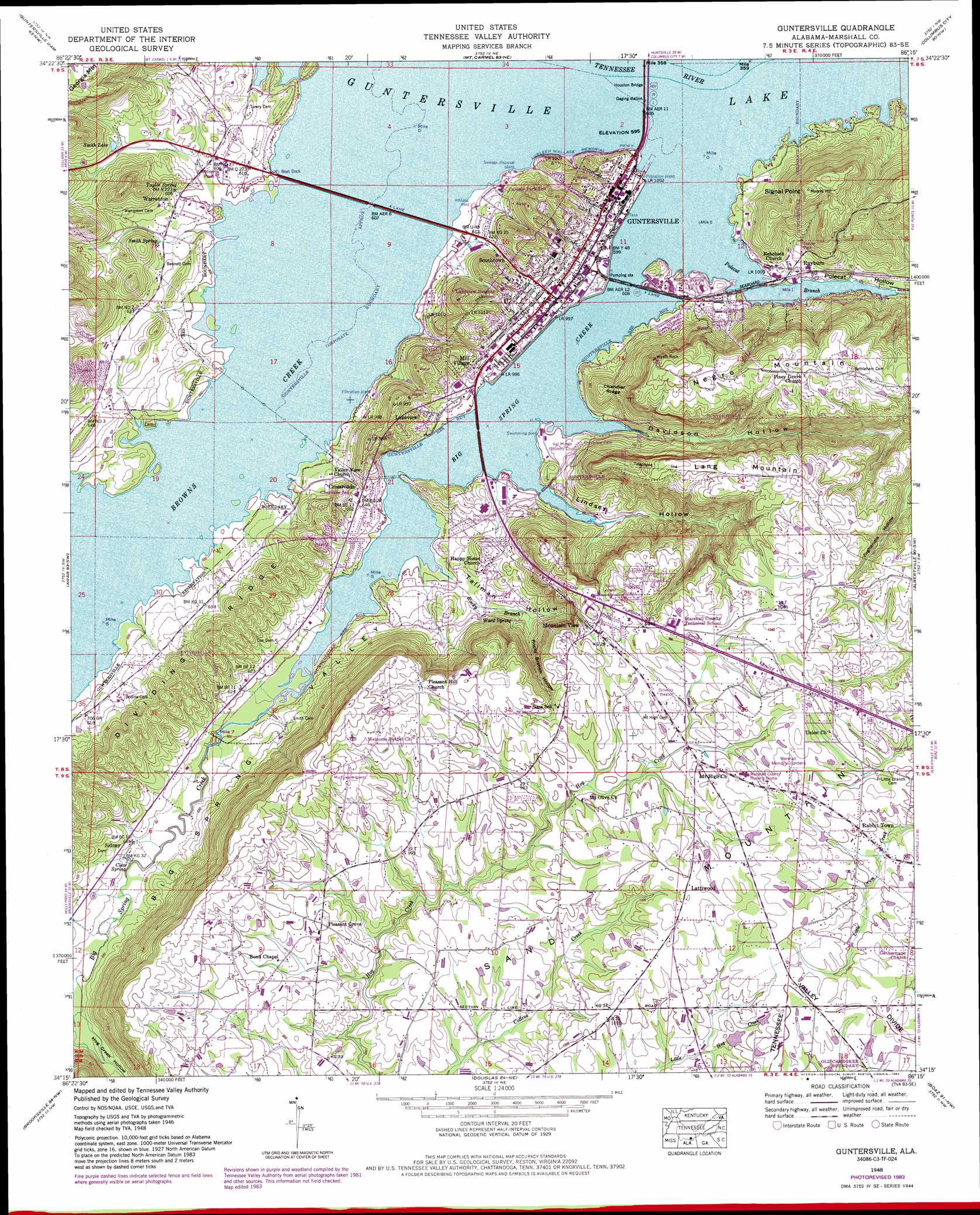
USGS Topo Quad 34086c3 - 1:24,000 scale
| Topo Map Name: | Guntersville |
| USGS Topo Quad ID: | 34086c3 |
| Print Size: | ca. 21 1/4" wide x 27" high |
| Southeast Coordinates: | 34.25° N latitude / 86.25° W longitude |
| Map Center Coordinates: | 34.3125° N latitude / 86.3125° W longitude |
| U.S. State: | AL |
| Filename: | o34086c3.jpg |
| Download Map JPG Image: | Guntersville topo map 1:24,000 scale |
| Map Type: | Topographic |
| Topo Series: | 7.5´ |
| Map Scale: | 1:24,000 |
| Source of Map Images: | United States Geological Survey (USGS) |
| Alternate Map Versions: |
Guntersville AL 1936 Download PDF Buy paper map Guntersville AL 1948, updated 1969 Download PDF Buy paper map Guntersville AL 1948, updated 1972 Download PDF Buy paper map Guntersville AL 1948, updated 1983 Download PDF Buy paper map Guntersville AL 1950 Download PDF Buy paper map Guntersville AL 2011 Download PDF Buy paper map Guntersville AL 2014 Download PDF Buy paper map |
1:24,000 Topo Quads surrounding Guntersville
Farley |
New Hope |
Grant |
Swearengin |
Langston |
Newsome Sinks |
Guntersville Dam |
Mount Carmel |
Columbus City |
Grove Oak |
Hulaco |
Arab |
Guntersville |
Albertville |
Painter |
Holly Pond |
Brooksville |
Douglas |
Boaz |
Rodentown |
Blountsville |
Clarence |
Altoona |
Howelton |
Gadsden West |
> Back to 34086a1 at 1:100,000 scale
> Back to 34086a1 at 1:250,000 scale
> Back to U.S. Topo Maps home
Guntersville topo map: Gazetteer
Guntersville: Airports
Smith Landing Field (historical) elevation 181m 593′Guntersville: Bars
Gunters Reef elevation 181m 593′Guntersville: Bridges
Houston Bridge elevation 181m 593′Guntersville: Capes
Signal Point elevation 326m 1069′Guntersville: Crossings
Guntersville Ferry (historical) elevation 181m 593′Guntersville: Lakes
Moore Pond (historical) elevation 181m 593′Smith Lake elevation 192m 629′
Guntersville: Parks
Big Spring Creek Small Wild Area elevation 183m 600′David Crockett Visit Lions Club Park elevation 182m 597′
Guntersville Municipal Park elevation 183m 600′
Ogletree Park elevation 185m 606′
Tom Jackson Park elevation 185m 606′
Guntersville: Pillars
Wyeth Rock elevation 327m 1072′Guntersville: Populated Places
Big Spring Creek Subdivision elevation 185m 606′Country Club Estates elevation 192m 629′
Crossroads elevation 200m 656′
Gregory (historical) elevation 312m 1023′
Guntersville elevation 194m 636′
Guntersville Shores elevation 272m 892′
Hide Away Acres elevation 182m 597′
Lakeview elevation 194m 636′
Lattiwood elevation 321m 1053′
Lindsay Lane elevation 302m 990′
Meadow Wood elevation 188m 616′
Mill Village elevation 202m 662′
Morrow Acres elevation 192m 629′
Mountain View elevation 300m 984′
Pleasant Grove elevation 305m 1000′
Rabbit Town elevation 306m 1003′
Rayburn elevation 189m 620′
Sandy Point Subdivision elevation 190m 623′
Sidney elevation 188m 616′
Signal Point Subdivision elevation 197m 646′
Smith Shores elevation 183m 600′
Southtown elevation 204m 669′
Street (historical) elevation 299m 980′
Sunrise Shores elevation 186m 610′
Warrenton elevation 189m 620′
Warrenton Subdivision elevation 190m 623′
Wyeth City elevation 182m 597′
Guntersville: Ridges
Chandler Ridge elevation 246m 807′Lang Mountain elevation 318m 1043′
Guntersville: Springs
Clear Spring elevation 186m 610′Smith Spring elevation 189m 620′
Taylor Spring elevation 189m 620′
Ward Spring elevation 189m 620′
Guntersville: Streams
Big Spring Creek elevation 181m 593′Browns Creek elevation 181m 593′
Hog Creek elevation 186m 610′
Polecat Branch elevation 181m 593′
Rocky Branch elevation 181m 593′
Guntersville: Summits
Moores Hill elevation 350m 1148′Negro Mountain elevation 336m 1102′
Guntersville: Valleys
Big Spring Valley elevation 187m 613′Davidson Hollow elevation 181m 593′
Hog Creek Hollow elevation 186m 610′
Lindsey Hollow elevation 181m 593′
Polecat Hollow elevation 181m 593′
Rocky Branch Hollow elevation 192m 629′
Tallman Hollow elevation 181m 593′
Guntersville digital topo map on disk
Buy this Guntersville topo map showing relief, roads, GPS coordinates and other geographical features, as a high-resolution digital map file on DVD: