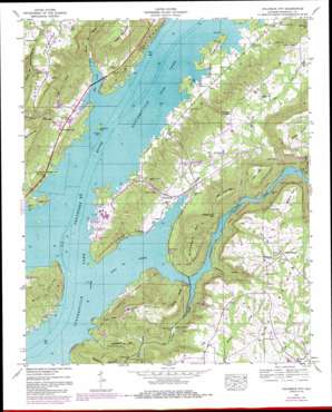
Columbus City Topo Map Alabama
To zoom in, hover over the map of Columbus City
USGS Topo Quad 34086d2 - 1:24,000 scale
| Topo Map Name: | Columbus City |
| USGS Topo Quad ID: | 34086d2 |
| Print Size: | ca. 21 1/4" wide x 27" high |
| Southeast Coordinates: | 34.375° N latitude / 86.125° W longitude |
| Map Center Coordinates: | 34.4375° N latitude / 86.1875° W longitude |
| U.S. State: | AL |
| Filename: | o34086d2.jpg |
| Download Map JPG Image: | Columbus City topo map 1:24,000 scale |
| Map Type: | Topographic |
| Topo Series: | 7.5´ |
| Map Scale: | 1:24,000 |
| Source of Map Images: | United States Geological Survey (USGS) |
| Alternate Map Versions: |
Columbus City AL 1936 Download PDF Buy paper map Columbus City AL 1947, updated 1972 Download PDF Buy paper map Columbus City AL 1947, updated 1985 Download PDF Buy paper map Columbus City AL 1949 Download PDF Buy paper map Columbus City AL 2011 Download PDF Buy paper map Columbus City AL 2014 Download PDF Buy paper map |
1:24,000 Topo Quads surrounding Columbus City
> Back to 34086a1 at 1:100,000 scale
> Back to 34086a1 at 1:250,000 scale
> Back to U.S. Topo Maps home
Columbus City topo map: Gazetteer
Columbus City: Bars
Buck Island Bar elevation 181m 593′Columbus Bar elevation 181m 593′
Gunters Bar elevation 181m 593′
Henrys Bar elevation 181m 593′
Lower Bar elevation 181m 593′
Columbus City: Bays
Mill Creek elevation 181m 593′Columbus City: Capes
Williams Point elevation 340m 1115′Columbus City: Crossings
Columbus City Ferry (historical) elevation 181m 593′Town Creek Ferry (historical) elevation 181m 593′
Columbus City: Gaps
Smith Gap elevation 329m 1079′The Narrows elevation 283m 928′
Village Ford Gap elevation 241m 790′
Winston Gap elevation 318m 1043′
Columbus City: Islands
Buck Island (historical) elevation 181m 593′Pine Island (historical) elevation 181m 593′
Columbus City: Parks
Lake Guntersville State Park elevation 270m 885′Columbus City: Populated Places
Alexander Subdivision elevation 201m 659′Asbury elevation 337m 1105′
Campbell Mill elevation 329m 1079′
Columbus City elevation 203m 666′
Five Points elevation 199m 652′
Glen Haven elevation 190m 623′
Little New York elevation 189m 620′
Meltonsville elevation 198m 649′
Mid (historical) elevation 207m 679′
Miller Subdivision elevation 198m 649′
Pine Island Subdivision elevation 193m 633′
Poplar Springs elevation 348m 1141′
Star Point Subdivision elevation 192m 629′
Tanglewood elevation 201m 659′
Columbus City: Ridges
Bailey Ridge elevation 296m 971′Cedar Ridge elevation 282m 925′
Columbus City: Springs
McDonald Spring elevation 303m 994′Columbus City: Streams
Chandler Branch elevation 182m 597′Duvall Branch elevation 182m 597′
Hurricane Branch elevation 181m 593′
Minky Creek elevation 182m 597′
Old Union Branch elevation 335m 1099′
Town Creek elevation 181m 593′
Columbus City: Summits
Center Point elevation 377m 1236′Ellenburg Mountain elevation 332m 1089′
Graveyard Hill elevation 293m 961′
John Doss Mountain elevation 355m 1164′
Little Mountain elevation 356m 1167′
McCorkle Mountain elevation 367m 1204′
Murphy Hill elevation 207m 679′
Negro Mountain elevation 377m 1236′
Stubblefield Mountain elevation 341m 1118′
Taylor Mountain elevation 346m 1135′
Columbus City: Valleys
Bryant Mill Hollow elevation 181m 593′Johnson Hollow elevation 182m 597′
Columbus City digital topo map on disk
Buy this Columbus City topo map showing relief, roads, GPS coordinates and other geographical features, as a high-resolution digital map file on DVD:


