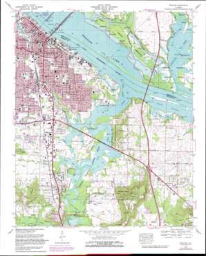
Decatur Topo Map Alabama
To zoom in, hover over the map of Decatur
USGS Topo Quad 34086e8 - 1:24,000 scale
| Topo Map Name: | Decatur |
| USGS Topo Quad ID: | 34086e8 |
| Print Size: | ca. 21 1/4" wide x 27" high |
| Southeast Coordinates: | 34.5° N latitude / 86.875° W longitude |
| Map Center Coordinates: | 34.5625° N latitude / 86.9375° W longitude |
| U.S. State: | AL |
| Filename: | o34086e8.jpg |
| Download Map JPG Image: | Decatur topo map 1:24,000 scale |
| Map Type: | Topographic |
| Topo Series: | 7.5´ |
| Map Scale: | 1:24,000 |
| Source of Map Images: | United States Geological Survey (USGS) |
| Alternate Map Versions: |
Decatur AL 1936 Download PDF Buy paper map Decatur AL 1950, updated 1952 Download PDF Buy paper map Decatur AL 1950, updated 1960 Download PDF Buy paper map Decatur AL 1963, updated 1966 Download PDF Buy paper map Decatur AL 1975, updated 1976 Download PDF Buy paper map Decatur AL 1975, updated 1983 Download PDF Buy paper map Decatur AL 1975, updated 1983 Download PDF Buy paper map Decatur AL 2011 Download PDF Buy paper map Decatur AL 2014 Download PDF Buy paper map |
| FStopo: | US Forest Service topo Decatur is available: Download FStopo PDF Download FStopo TIF |
1:24,000 Topo Quads surrounding Decatur
> Back to 34086e1 at 1:100,000 scale
> Back to 34086a1 at 1:250,000 scale
> Back to U.S. Topo Maps home
Decatur topo map: Gazetteer
Decatur: Airports
Robinson Private Airport elevation 189m 620′Decatur: Bars
Limestone Bar (historical) elevation 170m 557′South Flint River Bar (historical) elevation 170m 557′
Decatur: Bays
Garth Slough elevation 170m 557′Susie Hole elevation 170m 557′
Decatur: Bridges
Flint Bridge elevation 170m 557′Keller Memorial Bridge elevation 170m 557′
Norris Bridge elevation 172m 564′
Red Bank Bridge elevation 170m 557′
Decatur: Crossings
Burleson Ferry (historical) elevation 170m 557′Interchange 334 elevation 189m 620′
Mount Pisgah Ford elevation 170m 557′
Red Bank Ford elevation 170m 557′
Rhodes Ferry (historical) elevation 170m 557′
Decatur: Guts
Crabtree Slough elevation 170m 557′Dinsmore Slough elevation 170m 557′
Decatur: Harbors
Decatur Harbor elevation 170m 557′Disco Harbor elevation 170m 557′
Decatur: Islands
Flint Creek Island elevation 173m 567′Decatur: Lakes
Beaver Lake (historical) elevation 170m 557′English Pond elevation 180m 590′
Goose Pond (historical) elevation 170m 557′
Johnson Pond elevation 176m 577′
Swan Lake (historical) elevation 170m 557′
Decatur: Parks
Albany Heritage Neighborhood Historic District elevation 182m 597′Aquadome Park elevation 177m 580′
Bank Street-Old Decatur Historic District elevation 181m 593′
Delano Park elevation 178m 583′
Funland Park elevation 175m 574′
Malone Park elevation 171m 561′
Morgan Lake Park elevation 182m 597′
Point Mallard Park elevation 170m 557′
Rhodes Ferry Park elevation 177m 580′
Wheeler National Wildlife Refuge elevation 168m 551′
Decatur: Populated Places
Albany elevation 173m 567′Bayside elevation 174m 570′
Burningtree Estates elevation 177m 580′
Burningtree Mountain elevation 252m 826′
Cedar Lake elevation 174m 570′
Crowtown elevation 173m 567′
Decatur elevation 171m 561′
Fairview elevation 173m 567′
Flint City elevation 184m 603′
Hickory Hills elevation 181m 593′
Longleaf Estates elevation 186m 610′
Oakworth elevation 175m 574′
Priceville elevation 189m 620′
Rolling Hills elevation 198m 649′
Russell Village elevation 182m 597′
Six Way elevation 184m 603′
West Decatur elevation 176m 577′
Decatur: Reservoirs
Morgan Lake elevation 177m 580′Decatur: Ridges
Priceville Mountain elevation 259m 849′Decatur: Springs
Bird Spring elevation 196m 643′Mooresville Spring elevation 170m 557′
Parker Spring elevation 174m 570′
Decatur: Streams
Beaverdam Creek elevation 170m 557′Black Branch elevation 169m 554′
Black Branch elevation 170m 557′
Blue Hole Branch elevation 170m 557′
Brush Creek elevation 170m 557′
Clark Spring Branch elevation 171m 561′
Flint Creek elevation 170m 557′
Limestone Creek elevation 170m 557′
Long Branch elevation 171m 561′
Muddy Branch elevation 170m 557′
Piney Creek elevation 170m 557′
Village Branch elevation 172m 564′
Decatur: Summits
Bald Knob elevation 225m 738′Burleson Mountain elevation 269m 882′
Harris Mountain elevation 231m 757′
Decatur: Valleys
Peck Hollow elevation 182m 597′Decatur digital topo map on disk
Buy this Decatur topo map showing relief, roads, GPS coordinates and other geographical features, as a high-resolution digital map file on DVD:


