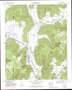
Paint Rock Topo Map Alabama
To zoom in, hover over the map of Paint Rock
USGS Topo Quad 34086f3 - 1:24,000 scale
| Topo Map Name: | Paint Rock |
| USGS Topo Quad ID: | 34086f3 |
| Print Size: | ca. 21 1/4" wide x 27" high |
| Southeast Coordinates: | 34.625° N latitude / 86.25° W longitude |
| Map Center Coordinates: | 34.6875° N latitude / 86.3125° W longitude |
| U.S. State: | AL |
| Filename: | o34086f3.jpg |
| Download Map JPG Image: | Paint Rock topo map 1:24,000 scale |
| Map Type: | Topographic |
| Topo Series: | 7.5´ |
| Map Scale: | 1:24,000 |
| Source of Map Images: | United States Geological Survey (USGS) |
| Alternate Map Versions: |
Paint Rock AL 1936 Download PDF Buy paper map Paint Rock AL 1948, updated 1966 Download PDF Buy paper map Paint Rock AL 1948, updated 1975 Download PDF Buy paper map Paint Rock AL 1948, updated 1976 Download PDF Buy paper map Paint Rock AL 1948, updated 1982 Download PDF Buy paper map Paint Rock AL 1948, updated 1982 Download PDF Buy paper map Paint Rock AL 1950 Download PDF Buy paper map Paint Rock AL 1997, updated 2001 Download PDF Buy paper map Paint Rock AL 2011 Download PDF Buy paper map Paint Rock AL 2014 Download PDF Buy paper map |
1:24,000 Topo Quads surrounding Paint Rock
> Back to 34086e1 at 1:100,000 scale
> Back to 34086a1 at 1:250,000 scale
> Back to U.S. Topo Maps home
Paint Rock topo map: Gazetteer
Paint Rock: Basins
Bucks Pocket elevation 354m 1161′Paint Rock: Capes
Bullock Point elevation 425m 1394′Frazier Point elevation 300m 984′
High Point elevation 471m 1545′
Nolton Point elevation 472m 1548′
Paint Rock: Crossings
Flippo Ford elevation 182m 597′Walker Mill Ford elevation 183m 600′
Wells Ford elevation 183m 600′
Paint Rock: Dams
Smith, Walker and Johnson Lake Dam elevation 211m 692′Paint Rock: Lakes
Big Lake elevation 183m 600′Paint Rock: Mines
Naught Mine elevation 347m 1138′Paint Rock: Parks
Elliott Reservation elevation 194m 636′Fern Cave National Wildlife Refuge elevation 276m 905′
Lacy Reservation elevation 184m 603′
Stevens Reservation elevation 201m 659′
Paint Rock: Populated Places
Garth elevation 199m 652′Paint Rock elevation 186m 610′
Trenton elevation 205m 672′
Woodville elevation 189m 620′
Paint Rock: Reservoirs
Smith, Walker and Johnson Lake elevation 211m 692′Paint Rock: Springs
Blair Spring elevation 206m 675′Blue Spring elevation 177m 580′
Chalybeate Spring elevation 450m 1476′
Cole Spring elevation 185m 606′
Daniel Spring elevation 207m 679′
Gilliam Spring elevation 186m 610′
Haley Spring elevation 182m 597′
Serotas Spring elevation 183m 600′
Spout Spring elevation 195m 639′
Paint Rock: Streams
Bingham Creek elevation 183m 600′Clear Creek elevation 183m 600′
Cole Spring Branch elevation 180m 590′
Laurel Branch elevation 180m 590′
Little Dry Creek elevation 186m 610′
Shanty Branch elevation 184m 603′
Paint Rock: Summits
Splitrock Mountain elevation 457m 1499′Paint Rock: Valleys
Bingham Cove elevation 189m 620′Butler Hollow elevation 186m 610′
Clay Cove elevation 187m 613′
Cotton Cove elevation 184m 603′
Finley Cove elevation 186m 610′
Hales Cove elevation 180m 590′
Kennamer Hollow elevation 180m 590′
Kirk Cove elevation 186m 610′
Paint Rock Valley elevation 176m 577′
Peters Cove elevation 187m 613′
Rousseau Hollow elevation 187m 613′
Stewart Cove elevation 183m 600′
Webb Hollow elevation 188m 616′
Paint Rock digital topo map on disk
Buy this Paint Rock topo map showing relief, roads, GPS coordinates and other geographical features, as a high-resolution digital map file on DVD:


