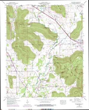
Moontown Topo Map Alabama
To zoom in, hover over the map of Moontown
USGS Topo Quad 34086f4 - 1:24,000 scale
| Topo Map Name: | Moontown |
| USGS Topo Quad ID: | 34086f4 |
| Print Size: | ca. 21 1/4" wide x 27" high |
| Southeast Coordinates: | 34.625° N latitude / 86.375° W longitude |
| Map Center Coordinates: | 34.6875° N latitude / 86.4375° W longitude |
| U.S. State: | AL |
| Filename: | o34086f4.jpg |
| Download Map JPG Image: | Moontown topo map 1:24,000 scale |
| Map Type: | Topographic |
| Topo Series: | 7.5´ |
| Map Scale: | 1:24,000 |
| Source of Map Images: | United States Geological Survey (USGS) |
| Alternate Map Versions: |
Moontown AL 1936 Download PDF Buy paper map Moontown AL 1948, updated 1952 Download PDF Buy paper map Moontown AL 1948, updated 1964 Download PDF Buy paper map Moontown AL 1948, updated 1974 Download PDF Buy paper map Moontown AL 1948, updated 1976 Download PDF Buy paper map Moontown AL 2011 Download PDF Buy paper map Moontown AL 2014 Download PDF Buy paper map |
1:24,000 Topo Quads surrounding Moontown
> Back to 34086e1 at 1:100,000 scale
> Back to 34086a1 at 1:250,000 scale
> Back to U.S. Topo Maps home
Moontown topo map: Gazetteer
Moontown: Airports
Gurley Airport elevation 191m 626′Madison County Sky Park elevation 196m 643′
Wood Airport elevation 192m 629′
Moontown: Basins
Lickskillet elevation 301m 987′Moontown: Bends
Salty Bottom elevation 189m 620′Moontown: Bridges
Cobb Bridge (historical) elevation 180m 590′Moontown: Capes
Blair Point elevation 271m 889′Grayson Point elevation 468m 1535′
Sublett Point elevation 366m 1200′
Moontown: Cliffs
Sublett Bluff elevation 207m 679′Moontown: Crossings
Adair Ford elevation 183m 600′Grayson Ford elevation 183m 600′
Moontown: Guts
Robinson Mill Creek elevation 180m 590′Moontown: Islands
Buffalo Island elevation 182m 597′Esslinger Island elevation 183m 600′
Moontown: Lakes
Collier Lake elevation 186m 610′Moontown: Populated Places
Berkley elevation 188m 616′Big Cove elevation 189m 620′
Brownsboro elevation 190m 623′
Cherrytree elevation 183m 600′
Dug Hill elevation 249m 816′
Gurley elevation 195m 639′
Moontown elevation 195m 639′
Sublett Mill elevation 183m 600′
Moontown: Post Offices
Gurley Post Office elevation 195m 639′Moontown: Springs
Beason Spring elevation 196m 643′Blair Spring elevation 222m 728′
Drake Spring elevation 195m 639′
Esslinger Spring elevation 183m 600′
Grayson Spring elevation 184m 603′
Moontown: Streams
Big Cove Creek elevation 181m 593′Buck Ditch elevation 180m 590′
Goose Creek elevation 180m 590′
Hurricane Creek elevation 183m 600′
Killingsworth Cove Branch elevation 188m 616′
Peevey Creek elevation 183m 600′
Sand Branch elevation 183m 600′
Section Branch elevation 193m 633′
Moontown: Summits
Candlestand elevation 252m 826′Chestnut Knob elevation 490m 1607′
Drake Mountain elevation 440m 1443′
Ginn Point elevation 434m 1423′
Gurley Mountain elevation 350m 1148′
High Point elevation 393m 1289′
Little Mountain elevation 288m 944′
Reed Mountain elevation 425m 1394′
Moontown: Valleys
Chandler Hollow elevation 204m 669′Esslinger Hollow elevation 199m 652′
Horse Cove elevation 185m 606′
Killingsworth Cove elevation 189m 620′
Little Cove elevation 182m 597′
Mills Hollow elevation 220m 721′
Negro Hollow elevation 204m 669′
Pelletier Hollow elevation 224m 734′
Potts Hollow elevation 183m 600′
Vinson Hollow elevation 224m 734′
Moontown digital topo map on disk
Buy this Moontown topo map showing relief, roads, GPS coordinates and other geographical features, as a high-resolution digital map file on DVD:


