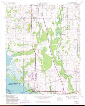
Tanner Topo Map Alabama
To zoom in, hover over the map of Tanner
USGS Topo Quad 34086f8 - 1:24,000 scale
| Topo Map Name: | Tanner |
| USGS Topo Quad ID: | 34086f8 |
| Print Size: | ca. 21 1/4" wide x 27" high |
| Southeast Coordinates: | 34.625° N latitude / 86.875° W longitude |
| Map Center Coordinates: | 34.6875° N latitude / 86.9375° W longitude |
| U.S. State: | AL |
| Filename: | o34086f8.jpg |
| Download Map JPG Image: | Tanner topo map 1:24,000 scale |
| Map Type: | Topographic |
| Topo Series: | 7.5´ |
| Map Scale: | 1:24,000 |
| Source of Map Images: | United States Geological Survey (USGS) |
| Alternate Map Versions: |
Tanner AL 1936 Download PDF Buy paper map Tanner AL 1938 Download PDF Buy paper map Tanner AL 1963, updated 1966 Download PDF Buy paper map Tanner AL 1963, updated 1975 Download PDF Buy paper map Tanner AL 2011 Download PDF Buy paper map Tanner AL 2014 Download PDF Buy paper map |
1:24,000 Topo Quads surrounding Tanner
> Back to 34086e1 at 1:100,000 scale
> Back to 34086a1 at 1:250,000 scale
> Back to U.S. Topo Maps home
Tanner topo map: Gazetteer
Tanner: Airports
Pryor Field elevation 178m 583′Tanner: Crossings
Interchange 340 elevation 182m 597′Tanner: Flats
Haney Bottoms elevation 177m 580′Tanner: Parks
Decatur Day Use Park elevation 170m 557′Swan Creek Waterfowl Management Area elevation 170m 557′
Tanner: Populated Places
Belle Mina elevation 183m 600′Decatur Junction elevation 171m 561′
Garner (historical) elevation 199m 652′
Harris Station elevation 172m 564′
Irvington elevation 181m 593′
Mooresville elevation 175m 574′
Murphree Place elevation 187m 613′
Orrville elevation 173m 567′
Peets Corner elevation 192m 629′
Salem Corner elevation 183m 600′
Sweetwater elevation 177m 580′
Tanner elevation 203m 666′
Tanner Crossroads elevation 200m 656′
Whiteside elevation 182m 597′
Tanner: Post Offices
Mooresville Post Office elevation 176m 577′Tanner Post Office elevation 202m 662′
Tanner: Springs
Page Spring elevation 201m 659′Pryor Spring elevation 173m 567′
Tanner: Streams
Little Piney Creek elevation 185m 606′Old Schoolhouse Branch elevation 181m 593′
Pryor Branch elevation 170m 557′
Spring Branch elevation 172m 564′
Spring Creek elevation 170m 557′
Swan Creek elevation 170m 557′
Tanner: Swamps
Blair Swamp elevation 184m 603′Harris-Sweetwater Dewatering Area elevation 170m 557′
Tanner digital topo map on disk
Buy this Tanner topo map showing relief, roads, GPS coordinates and other geographical features, as a high-resolution digital map file on DVD:


