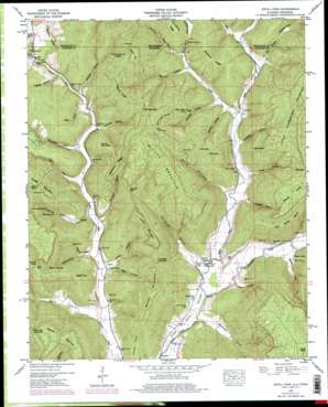
Estill Fork Topo Map Alabama
To zoom in, hover over the map of Estill Fork
USGS Topo Quad 34086h2 - 1:24,000 scale
| Topo Map Name: | Estill Fork |
| USGS Topo Quad ID: | 34086h2 |
| Print Size: | ca. 21 1/4" wide x 27" high |
| Southeast Coordinates: | 34.875° N latitude / 86.125° W longitude |
| Map Center Coordinates: | 34.9375° N latitude / 86.1875° W longitude |
| U.S. States: | AL, TN |
| Filename: | o34086h2.jpg |
| Download Map JPG Image: | Estill Fork topo map 1:24,000 scale |
| Map Type: | Topographic |
| Topo Series: | 7.5´ |
| Map Scale: | 1:24,000 |
| Source of Map Images: | United States Geological Survey (USGS) |
| Alternate Map Versions: |
Estill Fork AL 1939 Download PDF Buy paper map Estill Fork AL 1948, updated 1973 Download PDF Buy paper map Estill Fork AL 1948, updated 1976 Download PDF Buy paper map Estill Fork AL 1948, updated 1976 Download PDF Buy paper map Estill Fork AL 1951 Download PDF Buy paper map Estill Fork AL 2010 Download PDF Buy paper map Estill Fork AL 2011 Download PDF Buy paper map Estill Fork AL 2014 Download PDF Buy paper map |
1:24,000 Topo Quads surrounding Estill Fork
> Back to 34086e1 at 1:100,000 scale
> Back to 34086a1 at 1:250,000 scale
> Back to U.S. Topo Maps home
Estill Fork topo map: Gazetteer
Estill Fork: Basins
Bucky Sink elevation 398m 1305′Hard Sink elevation 403m 1322′
Moores Cove elevation 286m 938′
Moores Cove elevation 288m 944′
Estill Fork: Benches
Cold Spring Bench elevation 405m 1328′Estill Fork: Bridges
Freedom Bridge elevation 201m 659′Estill Fork: Capes
Prince Point elevation 299m 980′Sisk Point elevation 534m 1751′
Estill Fork: Cliffs
Deer Lick Bluff elevation 502m 1646′Sheep Bluff elevation 289m 948′
Estill Fork: Gaps
Fanning Low Gap elevation 465m 1525′Low Gap elevation 451m 1479′
Sisk Gap elevation 509m 1669′
The Narrows elevation 469m 1538′
Vandiver Low Gap elevation 437m 1433′
Walnut Gap elevation 439m 1440′
Estill Fork: Populated Places
Estillfork elevation 215m 705′Francisco elevation 234m 767′
Larkin elevation 204m 669′
Milan (historical) elevation 202m 662′
Estill Fork: Ridges
Backbone Ridge elevation 475m 1558′Bradford Ridge elevation 415m 1361′
Hogyard Ridge elevation 495m 1624′
Estill Fork: Springs
Bishop Spring elevation 213m 698′Larkin Spring elevation 267m 875′
Mill Seat Spring elevation 418m 1371′
Poplar Spring elevation 523m 1715′
Putman Spring elevation 262m 859′
Estill Fork: Streams
Bear Creek elevation 208m 682′Beaver Branch elevation 213m 698′
Bull Run elevation 210m 688′
Bull Run elevation 210m 688′
Burks Creek elevation 206m 675′
Estill Fork elevation 197m 646′
Granny Branch elevation 243m 797′
Hurricane Creek elevation 197m 646′
Larkin Spring Branch elevation 235m 770′
Pigeon Creek elevation 238m 780′
Puncheon Creek elevation 209m 685′
Reid Hollow Creek elevation 202m 662′
Suck Branch elevation 217m 711′
Suck Branch elevation 217m 711′
Estill Fork: Summits
Brewer Mountain elevation 511m 1676′Buddy Top elevation 400m 1312′
Doctor Knob elevation 537m 1761′
Hodge Mountain elevation 528m 1732′
Larkin Mountain elevation 530m 1738′
Little Cumberland Mountain elevation 543m 1781′
Maxwell Mountain elevation 509m 1669′
Miller Mountain elevation 531m 1742′
Round Mountain elevation 385m 1263′
Skillet Handle elevation 479m 1571′
The Knob elevation 510m 1673′
Wilson Top elevation 548m 1797′
Estill Fork: Valleys
Anderson Hollow elevation 198m 649′Bishop Cove elevation 213m 698′
Dodson Cove elevation 305m 1000′
Duboise Hollow elevation 216m 708′
Duboise Hollow elevation 217m 711′
Earwood Hollow elevation 217m 711′
Erwin Hollow elevation 205m 672′
Fanning Cove elevation 204m 669′
Fanning Hollow elevation 211m 692′
Gifford Hollow elevation 213m 698′
Henshaw Cove elevation 198m 649′
Holland Cove elevation 201m 659′
Honey Hollow elevation 219m 718′
Houston Hollow elevation 209m 685′
Kennedy Hollow elevation 218m 715′
Langham Hollow elevation 209m 685′
Mill Hollow elevation 212m 695′
Mill Hollow elevation 211m 692′
Newby Hollow elevation 221m 725′
Opossum Hollow elevation 231m 757′
Opossum Hollow elevation 227m 744′
Parks Hollow elevation 214m 702′
Puncheon Cove elevation 209m 685′
Reid Cove elevation 214m 702′
Reid Hollow elevation 202m 662′
Rich Hollow elevation 203m 666′
Shepard Hollow elevation 205m 672′
Shooting Ground Hollow elevation 309m 1013′
Simpson Hollow elevation 205m 672′
Slick Rock Hollow elevation 246m 807′
Trice Hollow elevation 207m 679′
Estill Fork digital topo map on disk
Buy this Estill Fork topo map showing relief, roads, GPS coordinates and other geographical features, as a high-resolution digital map file on DVD:


