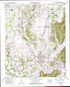
New Market Topo Map Alabama
To zoom in, hover over the map of New Market
USGS Topo Quad 34086h4 - 1:24,000 scale
| Topo Map Name: | New Market |
| USGS Topo Quad ID: | 34086h4 |
| Print Size: | ca. 21 1/4" wide x 27" high |
| Southeast Coordinates: | 34.875° N latitude / 86.375° W longitude |
| Map Center Coordinates: | 34.9375° N latitude / 86.4375° W longitude |
| U.S. States: | AL, TN |
| Filename: | o34086h4.jpg |
| Download Map JPG Image: | New Market topo map 1:24,000 scale |
| Map Type: | Topographic |
| Topo Series: | 7.5´ |
| Map Scale: | 1:24,000 |
| Source of Map Images: | United States Geological Survey (USGS) |
| Alternate Map Versions: |
New Market AL 1936 Download PDF Buy paper map New Market AL 1949, updated 1976 Download PDF Buy paper map New Market AL 1951, updated 1951 Download PDF Buy paper map New Market AL 2010 Download PDF Buy paper map New Market AL 2011 Download PDF Buy paper map New Market AL 2014 Download PDF Buy paper map |
1:24,000 Topo Quads surrounding New Market
> Back to 34086e1 at 1:100,000 scale
> Back to 34086a1 at 1:250,000 scale
> Back to U.S. Topo Maps home
New Market topo map: Gazetteer
New Market: Crossings
Bloucher Ford elevation 207m 679′New Market: Dams
Jimmy Johnston Lake Dam elevation 233m 764′New Market: Gaps
Cedar Gap elevation 292m 958′New Market: Lakes
Milner Pond elevation 274m 898′New Market: Parks
Sharon Johnson Park elevation 238m 780′New Market: Populated Places
Fairview elevation 268m 879′Fannings Crossing elevation 232m 761′
Hillsboro elevation 244m 800′
Mint Spring elevation 242m 793′
New Market elevation 231m 757′
Plevna elevation 259m 849′
Roseboro elevation 268m 879′
Steele Crossing elevation 272m 892′
Union Grove elevation 249m 816′
Walnut Grove elevation 249m 816′
New Market: Post Offices
New Market Post Office elevation 226m 741′New Market: Reservoirs
Jimmy Johnston Lake elevation 233m 764′New Market: Springs
Fuqua Spring elevation 294m 964′Prater Spring elevation 296m 971′
New Market: Streams
Bethany Branch elevation 210m 688′Hester Creek elevation 215m 705′
Jenny River elevation 244m 800′
Jenny River elevation 244m 800′
Payne Branch elevation 210m 688′
Rodgers Branch elevation 212m 695′
Swamp Branch elevation 229m 751′
Walker Branch elevation 235m 770′
New Market: Summits
Cedar Gap Mountain elevation 353m 1158′Graveyard Hill elevation 242m 793′
New Market: Valleys
Jones Hollow elevation 225m 738′Summers Hollow elevation 275m 902′
New Market digital topo map on disk
Buy this New Market topo map showing relief, roads, GPS coordinates and other geographical features, as a high-resolution digital map file on DVD:


