Bee Branch Topo Map Alabama
To zoom in, hover over the map of Bee Branch
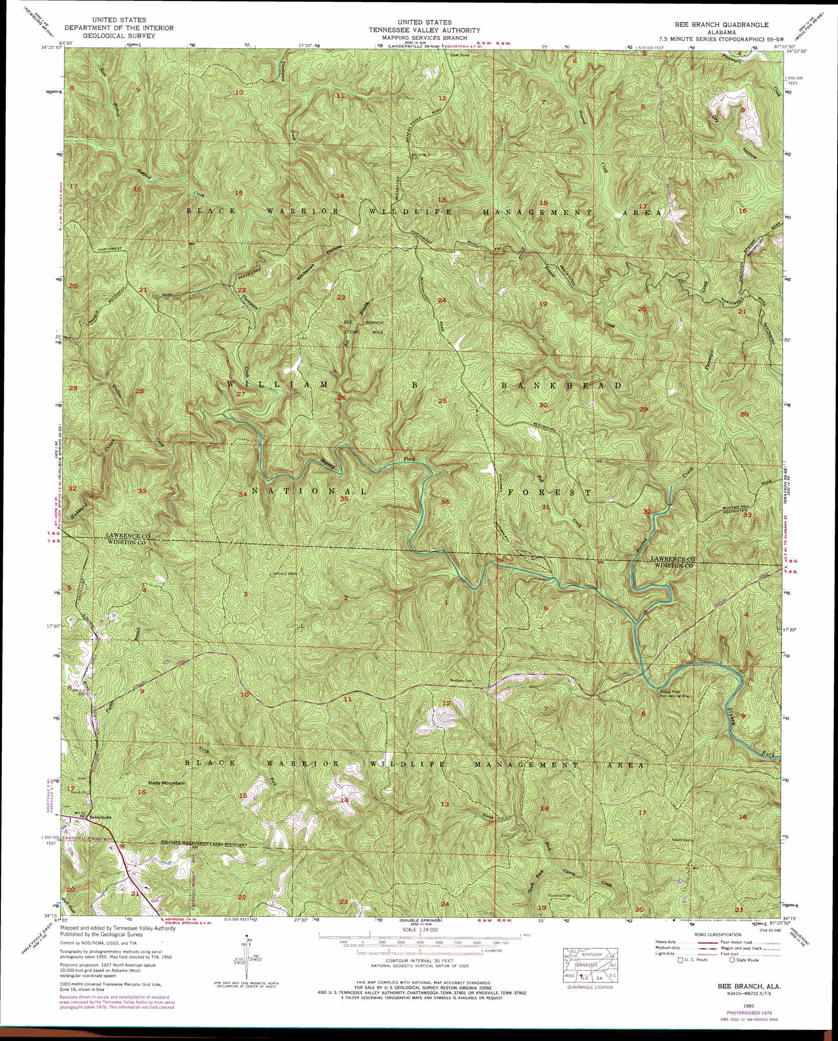
USGS Topo Quad 34087c4 - 1:24,000 scale
| Topo Map Name: | Bee Branch |
| USGS Topo Quad ID: | 34087c4 |
| Print Size: | ca. 21 1/4" wide x 27" high |
| Southeast Coordinates: | 34.25° N latitude / 87.375° W longitude |
| Map Center Coordinates: | 34.3125° N latitude / 87.4375° W longitude |
| U.S. State: | AL |
| Filename: | o34087c4.jpg |
| Download Map JPG Image: | Bee Branch topo map 1:24,000 scale |
| Map Type: | Topographic |
| Topo Series: | 7.5´ |
| Map Scale: | 1:24,000 |
| Source of Map Images: | United States Geological Survey (USGS) |
| Alternate Map Versions: |
Bee Branch AL 1960, updated 1961 Download PDF Buy paper map Bee Branch AL 1960, updated 1975 Download PDF Buy paper map Bee Branch AL 1960, updated 1977 Download PDF Buy paper map Bee Branch AL 1960, updated 1977 Download PDF Buy paper map Bee Branch AL 2000, updated 2003 Download PDF Buy paper map Bee Branch AL 2011 Download PDF Buy paper map Bee Branch AL 2014 Download PDF Buy paper map |
| FStopo: | US Forest Service topo Bee Branch is available: Download FStopo PDF Download FStopo TIF |
1:24,000 Topo Quads surrounding Bee Branch
Russellville |
Old Bethel |
Hatton |
Masterson |
Caddo |
Spruce Pine |
Newburg |
Landersville |
Moulton |
Oakville |
Phil Campbell |
Kinlock Spring |
Bee Branch |
Grayson |
Upshaw |
Haleyville West |
Haleyville East |
Double Springs |
Houston |
Addison |
Gold Mine |
Lynn |
Poplar Springs |
Black Pond |
Arley |
> Back to 34087a1 at 1:100,000 scale
> Back to 34086a1 at 1:250,000 scale
> Back to U.S. Topo Maps home
Bee Branch topo map: Gazetteer
Bee Branch: Falls
Parker Cascades elevation 201m 659′Parker Falls elevation 201m 659′
Bee Branch: Parks
Bee Branch Scenic Area elevation 224m 734′Bee Branch: Populated Places
Rabbittown elevation 293m 961′Bee Branch: Ridges
Devils Backbone elevation 253m 830′Bee Branch: Streams
Bee Branch elevation 184m 603′Borden Creek elevation 166m 544′
Braziel Creek elevation 170m 557′
Fall Creek elevation 167m 547′
Flannagin Creek elevation 174m 570′
Hagood Creek elevation 183m 600′
Hubbard Creek elevation 177m 580′
North Fork Caney Creek elevation 174m 570′
Parker Branch elevation 179m 587′
Quillan Creek elevation 179m 587′
Ross Branch elevation 198m 649′
South Fork Caney Creek elevation 174m 570′
Tedford Creek elevation 184m 603′
Thompson Creek elevation 177m 580′
Ugly Creek elevation 176m 577′
White Oak Branch elevation 182m 597′
Wolf Pen Branch elevation 169m 554′
Bee Branch: Summits
Balls Mountain elevation 300m 984′Needles Eye elevation 209m 685′
Bee Branch: Swamps
Gum Pond elevation 285m 935′Bee Branch: Trails
Borden Creek Trail elevation 170m 557′Braziel Creek Trail elevation 191m 626′
Bee Branch: Valleys
Bee Branch Canyon elevation 176m 577′Big Tree Canyon elevation 185m 606′
Braziel Canyon elevation 172m 564′
Buck Rough elevation 176m 577′
Clifty Canyon elevation 172m 564′
Dry Hollow elevation 188m 616′
Flannagin Canyon elevation 173m 567′
Hubbard Canyon elevation 182m 597′
Little Ugly Canyon elevation 173m 567′
North Caney Creek Canyon elevation 176m 577′
Parker Canyon elevation 250m 820′
Quillan Canyon elevation 180m 590′
Whiteoak Hollow elevation 192m 629′
Bee Branch digital topo map on disk
Buy this Bee Branch topo map showing relief, roads, GPS coordinates and other geographical features, as a high-resolution digital map file on DVD: