Masterson Topo Map Alabama
To zoom in, hover over the map of Masterson
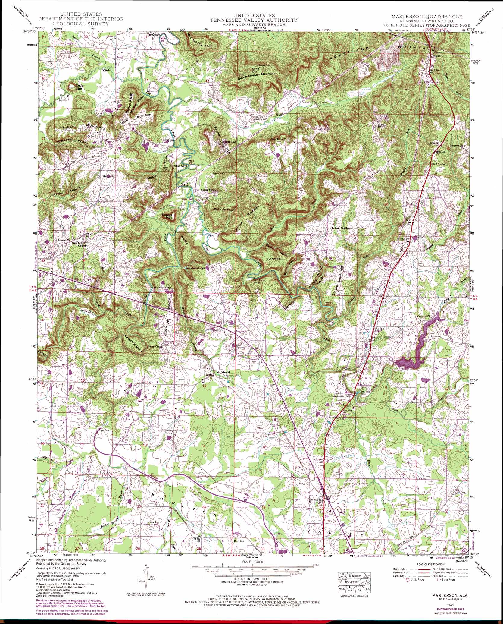
USGS Topo Quad 34087e3 - 1:24,000 scale
| Topo Map Name: | Masterson |
| USGS Topo Quad ID: | 34087e3 |
| Print Size: | ca. 21 1/4" wide x 27" high |
| Southeast Coordinates: | 34.5° N latitude / 87.25° W longitude |
| Map Center Coordinates: | 34.5625° N latitude / 87.3125° W longitude |
| U.S. State: | AL |
| Filename: | o34087e3.jpg |
| Download Map JPG Image: | Masterson topo map 1:24,000 scale |
| Map Type: | Topographic |
| Topo Series: | 7.5´ |
| Map Scale: | 1:24,000 |
| Source of Map Images: | United States Geological Survey (USGS) |
| Alternate Map Versions: |
Masterson AL 1936 Download PDF Buy paper map Masterson AL 1948, updated 1973 Download PDF Buy paper map Masterson AL 1951, updated 1951 Download PDF Buy paper map Masterson Mill AL 2011 Download PDF Buy paper map Masterson Mill AL 2014 Download PDF Buy paper map |
1:24,000 Topo Quads surrounding Masterson
Killen |
Wheeler Dam |
Rogersville |
Cairo |
Ripley |
Leighton |
Town Creek |
Courtland |
Hillsboro |
Jones Crossroads |
Old Bethel |
Hatton |
Masterson |
Caddo |
Trinity |
Newburg |
Landersville |
Moulton |
Oakville |
Danville |
Kinlock Spring |
Bee Branch |
Grayson |
Upshaw |
Massey |
> Back to 34087e1 at 1:100,000 scale
> Back to 34086a1 at 1:250,000 scale
> Back to U.S. Topo Maps home
Masterson topo map: Gazetteer
Masterson: Basins
Devils Den elevation 231m 757′Masterson: Bends
Horseshoe Bend elevation 195m 639′Masterson: Bridges
Jack Locke Bridge elevation 174m 570′John R Bridge elevation 174m 570′
Stickmeyer Bridge elevation 174m 570′
Masterson: Crossings
Trace Ford elevation 176m 577′Masterson: Dams
Masterson Mill Lake Dam elevation 200m 656′Masterson: Populated Places
Letson Settlement elevation 221m 725′Longtown elevation 199m 652′
Loosier elevation 228m 748′
Masterson Mill elevation 181m 593′
Mount Moriah elevation 195m 639′
Mountain Home elevation 227m 744′
Terrytown elevation 178m 583′
Masterson: Reservoirs
Moulton City Lake elevation 200m 656′Masterson: Ridges
Peanut Ridge elevation 223m 731′Masterson: Springs
Bluff Spring elevation 234m 767′Grandma Spring elevation 174m 570′
Horton Spring elevation 206m 675′
Poplar Spring elevation 207m 679′
Sinking Creek Spring elevation 194m 636′
Spout Spring elevation 233m 764′
Masterson: Streams
Bear Branch elevation 173m 567′Borden Creek elevation 179m 587′
Bridge Creek elevation 172m 564′
Cane Creek elevation 174m 570′
Clear Fork elevation 172m 564′
Cold Spring Branch elevation 179m 587′
Crooked Creek elevation 171m 561′
Crow Branch elevation 184m 603′
Doney Branch elevation 171m 561′
Early Branch elevation 201m 659′
Eddy Creek elevation 180m 590′
Key Branch elevation 179m 587′
Millie Branch elevation 173m 567′
Moore Creek elevation 180m 590′
Muddy Fork elevation 172m 564′
Muddy Prong elevation 183m 600′
Rocky Branch elevation 175m 574′
Rutherford Creek elevation 173m 567′
Sinking Creek elevation 179m 587′
Sulphur Spring Branch elevation 180m 590′
Turkey Creek elevation 213m 698′
Turkey Creek elevation 188m 616′
Wade Creek elevation 187m 613′
Walker Creek elevation 193m 633′
Masterson: Summits
Bash Mountain elevation 236m 774′Bethel Mountain elevation 229m 751′
Cedar Mountain elevation 205m 672′
Horton Mountain elevation 223m 731′
Mackeys Mountain elevation 243m 797′
Range Mountain elevation 218m 715′
Round Mountain elevation 218m 715′
Shoot Hill elevation 221m 725′
Sinking Creek Hill elevation 219m 718′
Stickmeyer Mountain elevation 227m 744′
Summerhouse Mountain elevation 241m 790′
Sykes Mountain elevation 231m 757′
Masterson: Valleys
Bullpen Hollow elevation 181m 593′Dickson Hollow elevation 177m 580′
Double Branch Hollow elevation 191m 626′
Fall Hollow elevation 194m 636′
Hightower Hollow elevation 176m 577′
Moats Hollow elevation 176m 577′
White Oak Hollow elevation 175m 574′
Masterson digital topo map on disk
Buy this Masterson topo map showing relief, roads, GPS coordinates and other geographical features, as a high-resolution digital map file on DVD: