Leighton Topo Map Alabama
To zoom in, hover over the map of Leighton
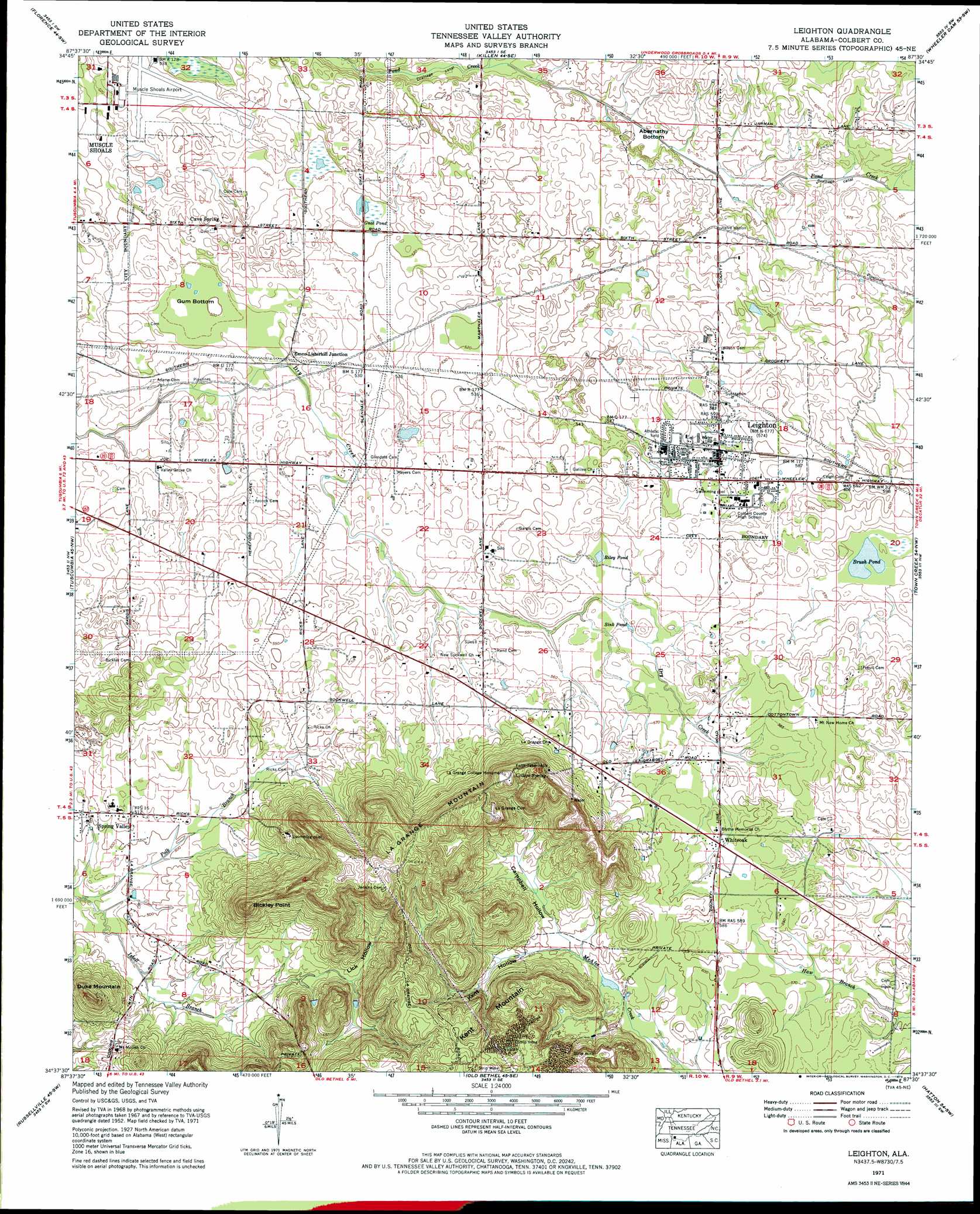
USGS Topo Quad 34087f5 - 1:24,000 scale
| Topo Map Name: | Leighton |
| USGS Topo Quad ID: | 34087f5 |
| Print Size: | ca. 21 1/4" wide x 27" high |
| Southeast Coordinates: | 34.625° N latitude / 87.5° W longitude |
| Map Center Coordinates: | 34.6875° N latitude / 87.5625° W longitude |
| U.S. State: | AL |
| Filename: | o34087f5.jpg |
| Download Map JPG Image: | Leighton topo map 1:24,000 scale |
| Map Type: | Topographic |
| Topo Series: | 7.5´ |
| Map Scale: | 1:24,000 |
| Source of Map Images: | United States Geological Survey (USGS) |
| Alternate Map Versions: |
Leighton AL 1936 Download PDF Buy paper map Leighton AL 1952, updated 1957 Download PDF Buy paper map Leighton AL 1971, updated 1973 Download PDF Buy paper map Leighton AL 1971, updated 1973 Download PDF Buy paper map Leighton AL 2011 Download PDF Buy paper map Leighton AL 2014 Download PDF Buy paper map |
1:24,000 Topo Quads surrounding Leighton
Threet |
Blackburn |
Pruitton |
Center Hill |
Lexington |
Sinking Creek |
Florence |
Killen |
Wheeler Dam |
Rogersville |
Pride |
Tuscumbia |
Leighton |
Town Creek |
Courtland |
Frankfort |
Russellville |
Old Bethel |
Hatton |
Masterson |
Isbell |
Spruce Pine |
Newburg |
Landersville |
Moulton |
> Back to 34087e1 at 1:100,000 scale
> Back to 34086a1 at 1:250,000 scale
> Back to U.S. Topo Maps home
Leighton topo map: Gazetteer
Leighton: Airports
Muscle Shoals Regional Airport elevation 165m 541′Leighton: Basins
Gum Bottom elevation 152m 498′Leighton: Flats
Abernathy Bottom elevation 162m 531′Leighton: Lakes
Alcock Pond elevation 156m 511′Bates Pond (historical) elevation 165m 541′
Brush Pond elevation 173m 567′
Gnat Pond elevation 161m 528′
Haw Pond elevation 157m 515′
Poplar Pond (historical) elevation 166m 544′
Riley Pond elevation 170m 557′
Sink Pond elevation 169m 554′
Leighton: Parks
LaGrange College Monument elevation 250m 820′Leighton: Pillars
Sand Rock elevation 246m 807′Leighton: Populated Places
Campbell Settlement (historical) elevation 202m 662′Cave Spring elevation 164m 538′
Emco-Listerhill Junction elevation 158m 518′
Hunter (historical) elevation 157m 515′
La Grange (historical) elevation 249m 816′
Leighton elevation 173m 567′
Spring Valley elevation 156m 511′
Valley Grove elevation 156m 511′
Whiteoak elevation 179m 587′
Leighton: Post Offices
Hunter Post Office (historical) elevation 157m 515′La Grange Post Office (historical) elevation 249m 816′
Leighton: Springs
College Spring elevation 242m 793′Sand Spring elevation 206m 675′
Leighton: Streams
Isbell Branch elevation 143m 469′Leighton: Summits
Bickley Point elevation 255m 836′Duke Mountain elevation 221m 725′
Kent Mountain elevation 244m 800′
LaGrange Mountain elevation 262m 859′
Leighton: Swamps
Gnat Pond elevation 159m 521′Leighton: Valleys
Campbell Hollow elevation 180m 590′Kent Hollow elevation 179m 587′
Lick Hollow elevation 161m 528′
Leighton digital topo map on disk
Buy this Leighton topo map showing relief, roads, GPS coordinates and other geographical features, as a high-resolution digital map file on DVD: