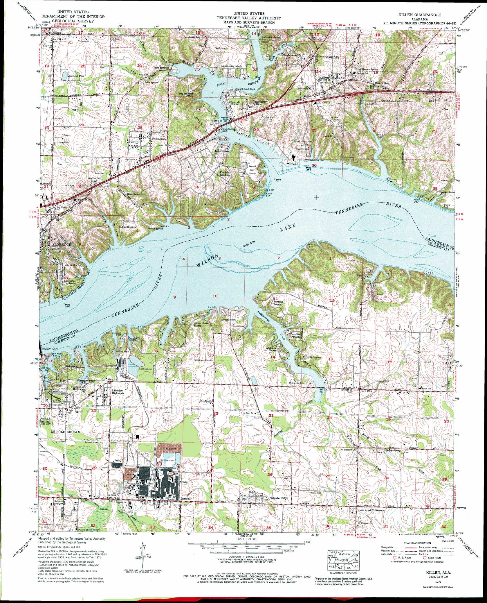
Killen Topo Map Alabama
To zoom in, hover over the map of Killen
USGS Topo Quad 34087g5 - 1:24,000 scale
| Topo Map Name: | Killen |
| USGS Topo Quad ID: | 34087g5 |
| Print Size: | ca. 21 1/4" wide x 27" high |
| Southeast Coordinates: | 34.75° N latitude / 87.5° W longitude |
| Map Center Coordinates: | 34.8125° N latitude / 87.5625° W longitude |
| U.S. State: | AL |
| Filename: | o34087g5.jpg |
| Download Map JPG Image: | Killen topo map 1:24,000 scale |
| Map Type: | Topographic |
| Topo Series: | 7.5´ |
| Map Scale: | 1:24,000 |
| Source of Map Images: | United States Geological Survey (USGS) |
| Alternate Map Versions: |
Killen AL 1936 Download PDF Buy paper map Killen AL 1953, updated 1957 Download PDF Buy paper map Killen AL 1971, updated 1973 Download PDF Buy paper map Killen AL 1971, updated 1991 Download PDF Buy paper map Killen AL 1971, updated 1991 Download PDF Buy paper map Killen AL 2011 Download PDF Buy paper map Killen AL 2014 Download PDF Buy paper map |
1:24,000 Topo Quads surrounding Killen
Cypress Inn |
Whitten |
Saint Joseph |
Loretto |
Bonnertown |
Threet |
Blackburn |
Pruitton |
Center Hill |
Lexington |
Sinking Creek |
Florence |
Killen |
Wheeler Dam |
Rogersville |
Pride |
Tuscumbia |
Leighton |
Town Creek |
Courtland |
Frankfort |
Russellville |
Old Bethel |
Hatton |
Masterson |
> Back to 34087e1 at 1:100,000 scale
> Back to 34086a1 at 1:250,000 scale
> Back to U.S. Topo Maps home
Killen topo map: Gazetteer
Killen: Airports
Landing Strip elevation 182m 597′Killen: Bars
Bainbridge Eddy (historical) elevation 155m 508′Big Jump Bar (historical) elevation 155m 508′
Big Muscle Shoals (historical) elevation 155m 508′
Dry Bar (historical) elevation 155m 508′
Little Jump Bar (historical) elevation 155m 508′
Little Muscle Shoals (historical) elevation 155m 508′
Muscle Shoals elevation 155m 508′
Poor Horse Bar (historical) elevation 155m 508′
Raccoon Bar (historical) elevation 155m 508′
Killen: Bridges
Shoal Creek Bridge elevation 155m 508′Killen: Canals
Muscle Shoals Canal (historical) elevation 155m 508′Shoal Creek Aqueduct (historical) elevation 155m 508′
Killen: Crossings
Bainbridge Ferry (historical) elevation 155m 508′Killen: Dams
Lock Number Eight (historical) elevation 155m 508′Lock Number Nine (historical) elevation 155m 508′
Lock Number Seven (historical) elevation 155m 508′
Lock Number Six (historical) elevation 155m 508′
Killen: Guts
Tate Slough elevation 155m 508′Killen: Islands
Five Acre Island (historical) elevation 155m 508′Forty Acres Island (historical) elevation 155m 508′
Kings Island (historical) elevation 155m 508′
Polk Island (historical) elevation 155m 508′
Resting Island (historical) elevation 155m 508′
Turkey Chute Island (historical) elevation 155m 508′
Killen: Lakes
Kasmeier Pond elevation 185m 606′Killen: Parks
Killen Park elevation 195m 639′Lock Six Day Use Area elevation 163m 534′
Killen: Populated Places
Alabama Shores elevation 166m 544′Bainbridge (historical) elevation 155m 508′
Bainbridge (historical) elevation 172m 564′
Bellemeade elevation 189m 620′
Brooks Acres elevation 167m 547′
Davidsons Cross Roads (historical) elevation 174m 570′
Detroit Park elevation 161m 528′
East Killen elevation 169m 554′
Elm Acres elevation 194m 636′
Emerald Shores elevation 156m 511′
Evergreen Estates elevation 199m 652′
Ford City elevation 167m 547′
Hideaway Hills elevation 177m 580′
Indian Springs elevation 176m 577′
Killen elevation 186m 610′
Kingman (historical) elevation 155m 508′
Lake Coves elevation 161m 528′
Lakeside Acres elevation 155m 508′
Lakeside Highlands elevation 181m 593′
Lakeview elevation 161m 528′
Lakeview elevation 171m 561′
Lakeview Heights elevation 178m 583′
Lakeview Highlands elevation 173m 567′
Lauderdale Beach elevation 161m 528′
Lingerlost elevation 159m 521′
Listerhill elevation 168m 551′
Lock Six elevation 195m 639′
Lockland elevation 187m 613′
Masonville (historical) elevation 182m 597′
Morningside Heights elevation 181m 593′
Mount Pleasant (historical) elevation 160m 524′
Nitrate City elevation 174m 570′
Paradise Points elevation 165m 541′
Peytona Points elevation 174m 570′
Rivermont elevation 180m 590′
Saint Florian elevation 190m 623′
Shoals Acres elevation 162m 531′
Sky Park elevation 166m 544′
Sombrero Acres elevation 161m 528′
Steenson Hollow elevation 157m 515′
Underwood Crossroads elevation 186m 610′
Village Pines elevation 201m 659′
Virginia Shores elevation 166m 544′
Wilson Heights elevation 189m 620′
Wilson Lake Shores elevation 172m 564′
Woodlawn elevation 197m 646′
Killen: Post Offices
Bainbridge Post Office (historical) elevation 172m 564′Kingman Post Office (historical) elevation 155m 508′
Killen: Rapids
Galloping Waters (historical) elevation 155m 508′Killen: Springs
Henson Spring elevation 172m 564′Indian Spring elevation 164m 538′
Price Spring elevation 172m 564′
Shegog Spring elevation 168m 551′
Tate Springs elevation 174m 570′
Killen: Streams
Brush Creek elevation 155m 508′Hawkins Creek elevation 155m 508′
McKiernan Creek elevation 155m 508′
Price Branch elevation 155m 508′
Saint Florian Branch elevation 155m 508′
Shegog Creek elevation 155m 508′
Shoal Creek elevation 155m 508′
Sixmile Creek elevation 155m 508′
Killen: Valleys
Fleet Hollow elevation 155m 508′Killen digital topo map on disk
Buy this Killen topo map showing relief, roads, GPS coordinates and other geographical features, as a high-resolution digital map file on DVD: