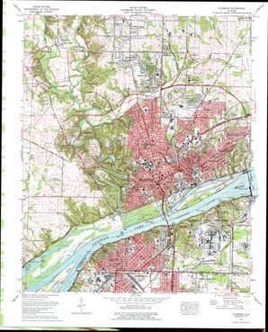
Florence Topo Map Alabama
To zoom in, hover over the map of Florence
USGS Topo Quad 34087g6 - 1:24,000 scale
| Topo Map Name: | Florence |
| USGS Topo Quad ID: | 34087g6 |
| Print Size: | ca. 21 1/4" wide x 27" high |
| Southeast Coordinates: | 34.75° N latitude / 87.625° W longitude |
| Map Center Coordinates: | 34.8125° N latitude / 87.6875° W longitude |
| U.S. State: | AL |
| Filename: | o34087g6.jpg |
| Download Map JPG Image: | Florence topo map 1:24,000 scale |
| Map Type: | Topographic |
| Topo Series: | 7.5´ |
| Map Scale: | 1:24,000 |
| Source of Map Images: | United States Geological Survey (USGS) |
| Alternate Map Versions: |
Florence AL 1936 Download PDF Buy paper map Florence AL 1957, updated 1958 Download PDF Buy paper map Florence AL 1957, updated 1966 Download PDF Buy paper map Florence AL 1971, updated 1972 Download PDF Buy paper map Florence AL 1971, updated 1977 Download PDF Buy paper map Florence AL 1971, updated 1977 Download PDF Buy paper map Florence AL 2011 Download PDF Buy paper map Florence AL 2014 Download PDF Buy paper map |
1:24,000 Topo Quads surrounding Florence
> Back to 34087e1 at 1:100,000 scale
> Back to 34086a1 at 1:250,000 scale
> Back to U.S. Topo Maps home
Florence topo map: Gazetteer
Florence: Bars
Cow Ford Bar elevation 127m 416′Tuscumbia Bar elevation 126m 413′
Florence: Basins
Smith Bottom elevation 161m 528′Florence: Bays
O'Neal Harbor elevation 126m 413′Florence: Bridges
Cypress Creek Bridge elevation 132m 433′Jackson Ford Bridge elevation 144m 472′
O'Neal Bridge elevation 126m 413′
Florence: Canals
Florence Canal elevation 126m 413′Florence: Cliffs
York Bluffs elevation 126m 413′Florence: Crossings
Florence Ferry (historical) elevation 126m 413′Jackson Ford elevation 144m 472′
Jacksons Crossing (historical) elevation 126m 413′
Sheffield Ferry (historical) elevation 126m 413′
Florence: Dams
Wilson Dam elevation 153m 501′Florence: Flats
McFarland Bottoms elevation 127m 416′Florence: Islands
Jackson Island elevation 129m 423′Patton Island elevation 128m 419′
Florence: Parks
Cox Creek Park elevation 151m 495′Florence Municipal Park elevation 129m 423′
McFarland Park elevation 128m 419′
North Alabama State Fair Park elevation 152m 498′
North Florence Park elevation 178m 583′
Point Park elevation 177m 580′
Sannoner Historic District elevation 178m 583′
Tenth Avenue Park elevation 161m 528′
Tri Cities Park elevation 166m 544′
Walnut Street Historic District elevation 174m 570′
Wildwood Park elevation 166m 544′
Wilson Park elevation 175m 574′
Wood Avenue Historic District elevation 183m 600′
York Terrace Park elevation 170m 557′
Florence: Populated Places
Alexander Heights elevation 173m 567′Beckman elevation 186m 610′
Beechwood elevation 184m 603′
Briarcliff elevation 172m 564′
Buckingham elevation 157m 515′
Canaan (historical) elevation 160m 524′
Chisholm Hills elevation 181m 593′
Cliff Haven elevation 180m 590′
Cloverdale Heights elevation 193m 633′
Country Club Acres elevation 166m 544′
Creekwood elevation 175m 574′
Cypress Crest elevation 179m 587′
Cypress Forest elevation 167m 547′
Cypress Heights elevation 165m 541′
East Florence elevation 167m 547′
East Sheffield elevation 175m 574′
Easton elevation 164m 538′
Edgemont elevation 182m 597′
Fairview elevation 144m 472′
Florence elevation 167m 547′
Forest Hills elevation 181m 593′
Furnace Hill (historical) elevation 149m 488′
Glendale Estates elevation 168m 551′
Greenbrier elevation 184m 603′
Heathrow elevation 177m 580′
Hickory Hills elevation 186m 610′
Loyall (historical) elevation 150m 492′
Mansion View elevation 159m 521′
Mars Hill elevation 166m 544′
McGee Town elevation 179m 587′
Morningdale elevation 180m 590′
New Castle Estates elevation 181m 593′
North Florence elevation 181m 593′
North Port (historical) elevation 129m 423′
Northwood Hills elevation 182m 597′
Northwood Park elevation 165m 541′
Olland elevation 159m 521′
Petersville elevation 186m 610′
River Oaks elevation 171m 561′
Rose Park elevation 186m 610′
Sheffield elevation 157m 515′
Sheffield Heights elevation 170m 557′
Sherill Gardens elevation 162m 531′
Sherwood Forest elevation 169m 554′
Six Points elevation 179m 587′
South Florence elevation 151m 495′
The Cedars elevation 182m 597′
Three Forks elevation 182m 597′
Twin Brooks elevation 167m 547′
Underwood elevation 183m 600′
Underwood Estates elevation 192m 629′
Vestavia Gardens elevation 179m 587′
Washington Park elevation 158m 518′
Weeden Heights elevation 183m 600′
Wilson Dam Village Number Three (historical) elevation 171m 561′
Windcrest elevation 186m 610′
Windsor Heights elevation 176m 577′
Woodlawn Heights elevation 157m 515′
Florence: Post Offices
Wilson Dam Post Office (historical) elevation 168m 551′Florence: Reservoirs
Wilson Lake elevation 154m 505′Florence: Springs
Beasley Spring elevation 137m 449′Beaver Dam Creek Springs elevation 127m 416′
Burtwell Spring elevation 157m 515′
King Spring elevation 167m 547′
Valley Spring elevation 156m 511′
Florence: Streams
Bailey Branch elevation 151m 495′Cox Creek elevation 140m 459′
Craven Branch elevation 167m 547′
Cypress Creek elevation 127m 416′
Cypress Creek elevation 127m 416′
Huddon Creek elevation 166m 544′
Little Cypress Creek elevation 143m 469′
Pond Creek elevation 126m 413′
Sweetwater Creek elevation 128m 419′
Wilson Creek elevation 166m 544′
Florence: Summits
River Hill elevation 150m 492′Waumanona Mound elevation 140m 459′
Florence: Valleys
Jackson Hollow elevation 126m 413′Jones Hollow elevation 128m 419′
Stewart Spring Hollow elevation 129m 423′
Florence digital topo map on disk
Buy this Florence topo map showing relief, roads, GPS coordinates and other geographical features, as a high-resolution digital map file on DVD:


