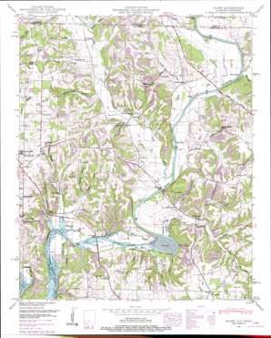
Salem Topo Map Alabama
To zoom in, hover over the map of Salem
USGS Topo Quad 34087h1 - 1:24,000 scale
| Topo Map Name: | Salem |
| USGS Topo Quad ID: | 34087h1 |
| Print Size: | ca. 21 1/4" wide x 27" high |
| Southeast Coordinates: | 34.875° N latitude / 87° W longitude |
| Map Center Coordinates: | 34.9375° N latitude / 87.0625° W longitude |
| U.S. States: | AL, TN |
| Filename: | o34087h1.jpg |
| Download Map JPG Image: | Salem topo map 1:24,000 scale |
| Map Type: | Topographic |
| Topo Series: | 7.5´ |
| Map Scale: | 1:24,000 |
| Source of Map Images: | United States Geological Survey (USGS) |
| Alternate Map Versions: |
Salem AL 1936 Download PDF Buy paper map Salem AL 1948, updated 1974 Download PDF Buy paper map Salem AL 1951 Download PDF Buy paper map Salem AL 2010 Download PDF Buy paper map Salem AL 2011 Download PDF Buy paper map Salem AL 2014 Download PDF Buy paper map |
1:24,000 Topo Quads surrounding Salem
> Back to 34087e1 at 1:100,000 scale
> Back to 34086a1 at 1:250,000 scale
> Back to U.S. Topo Maps home
Salem topo map: Gazetteer
Salem: Bars
Chickasaw Shoals elevation 208m 682′Salem: Bends
Round Bottom elevation 173m 567′Salem: Bridges
Buck Island Bridge elevation 170m 557′Easter Ferry Bridge (historical) elevation 171m 561′
Maple Bridge (historical) elevation 171m 561′
Salem: Cliffs
Winding Stair Bluff elevation 214m 702′Salem: Crossings
Easter Ferry (historical) elevation 171m 561′Grigsby Ferry (historical) elevation 170m 557′
Salem: Islands
Buck Island elevation 170m 557′Gallus Island elevation 171m 561′
Mason Island elevation 171m 561′
Salem: Populated Places
Clifton (historical) elevation 213m 698′Gipsy elevation 177m 580′
Gourdsville elevation 186m 610′
Leggtown elevation 179m 587′
Salem elevation 240m 787′
Spencer Store elevation 182m 597′
Walnut Hill elevation 180m 590′
Salem: Post Offices
Gilbertsborough Post Office (historical) elevation 189m 620′Salem: Ridges
Cabbage Ridge elevation 241m 790′Gray Ridge elevation 239m 784′
Salem: Springs
Beasley Spring elevation 181m 593′Blue Spring elevation 175m 574′
Cave Spring elevation 199m 652′
Cedar Bluff Spring elevation 179m 587′
Gaston Cave Spring elevation 205m 672′
Gipsy Spring elevation 180m 590′
Hillside Spring elevation 202m 662′
Monday Spring elevation 238m 780′
Salem Spring elevation 174m 570′
Salem: Streams
Baptizing Branch elevation 170m 557′Coffman Branch elevation 171m 561′
Collier Branch elevation 171m 561′
Crooked Branch elevation 171m 561′
Davis Branch elevation 174m 570′
Double Branch elevation 170m 557′
Jenkins Creek elevation 171m 561′
Mill Creek elevation 176m 577′
Moore Branch elevation 180m 590′
Shoal Creek elevation 171m 561′
Sulphur Creek elevation 171m 561′
Turkey Creek elevation 228m 748′
Williams Spring Branch elevation 198m 649′
Witty Branch elevation 171m 561′
Witty Creek elevation 178m 583′
Salem: Valleys
Buzzard Roost Hollow elevation 181m 593′Chatman Hollow elevation 170m 557′
Dupree Hollow elevation 180m 590′
Gardner Hollow elevation 193m 633′
Gaston Hollow elevation 190m 623′
Happy Hollow elevation 179m 587′
Horton Hollow elevation 170m 557′
Jones Hollow elevation 174m 570′
Patterson Hollow elevation 171m 561′
Smith Hollow elevation 184m 603′
Smith Hollow elevation 173m 567′
Vaughn Hollow elevation 176m 577′
Salem digital topo map on disk
Buy this Salem topo map showing relief, roads, GPS coordinates and other geographical features, as a high-resolution digital map file on DVD:


