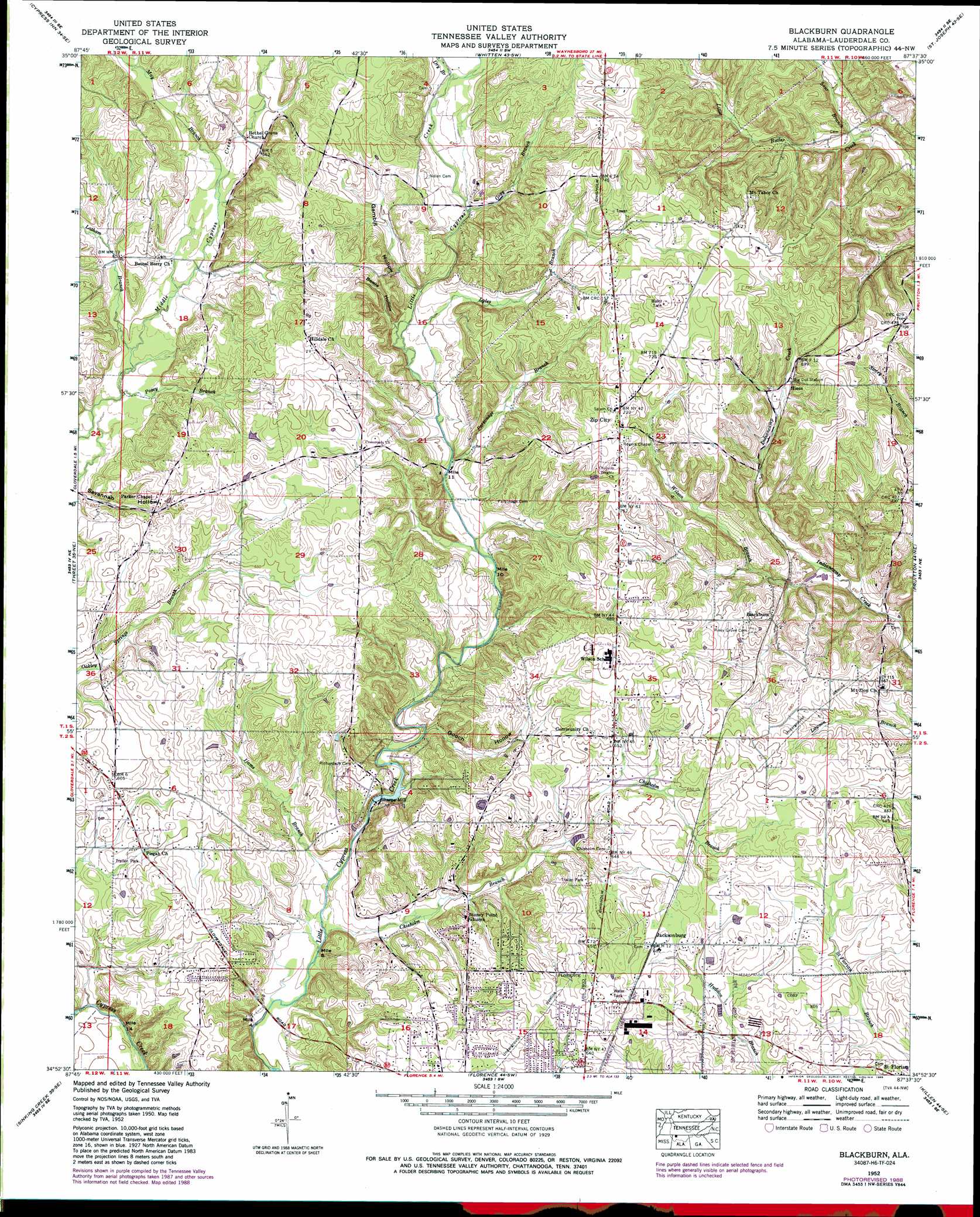
Blackburn Topo Map Alabama
To zoom in, hover over the map of Blackburn
USGS Topo Quad 34087h6 - 1:24,000 scale
| Topo Map Name: | Blackburn |
| USGS Topo Quad ID: | 34087h6 |
| Print Size: | ca. 21 1/4" wide x 27" high |
| Southeast Coordinates: | 34.875° N latitude / 87.625° W longitude |
| Map Center Coordinates: | 34.9375° N latitude / 87.6875° W longitude |
| U.S. State: | AL |
| Filename: | o34087h6.jpg |
| Download Map JPG Image: | Blackburn topo map 1:24,000 scale |
| Map Type: | Topographic |
| Topo Series: | 7.5´ |
| Map Scale: | 1:24,000 |
| Source of Map Images: | United States Geological Survey (USGS) |
| Alternate Map Versions: |
Blackburn AL 1936, updated 1936 Download PDF Buy paper map Blackburn AL 1952, updated 1958 Download PDF Buy paper map Blackburn AL 1952, updated 1973 Download PDF Buy paper map Blackburn AL 1952, updated 1989 Download PDF Buy paper map Blackburn AL 2011 Download PDF Buy paper map Blackburn AL 2014 Download PDF Buy paper map |
1:24,000 Topo Quads surrounding Blackburn
Martins Mills |
Three Churches |
Collinwood |
Westpoint |
Long Branch |
Ransom Stand |
Cypress Inn |
Whitten |
Saint Joseph |
Loretto |
Wright |
Threet |
Blackburn |
Pruitton |
Center Hill |
Cherokee |
Sinking Creek |
Florence |
Killen |
Wheeler Dam |
Barton |
Pride |
Tuscumbia |
Leighton |
Town Creek |
> Back to 34087e1 at 1:100,000 scale
> Back to 34086a1 at 1:250,000 scale
> Back to U.S. Topo Maps home
Blackburn topo map: Gazetteer
Blackburn: Dams
Sharps Mill Dam elevation 162m 531′Blackburn: Populated Places
Bethel Grove elevation 195m 639′Blackburn elevation 189m 620′
Fairview elevation 184m 603′
Hines elevation 204m 669′
Jacksonburg elevation 202m 662′
Keys Chapel (historical) elevation 212m 695′
Oak Hill elevation 195m 639′
Sharps Mill elevation 161m 528′
Stoney Point (historical) elevation 170m 557′
Suncrest elevation 197m 646′
Terrace View elevation 198m 649′
Twin Oaks elevation 201m 659′
Webster (historical) elevation 195m 639′
Wilkes Park elevation 196m 643′
Wilson elevation 217m 711′
Zip City elevation 222m 728′
Blackburn: Post Offices
Hope Post Office elevation 195m 639′Blackburn: Reservoirs
Sharps Mill Pond elevation 162m 531′Blackburn: Streams
Bowie Branch elevation 180m 590′Chisholm Branch elevation 155m 508′
Dry Branch elevation 194m 636′
Dry Branch elevation 194m 636′
Gray Branch elevation 191m 626′
Ijams Branch elevation 159m 521′
Latham Branch elevation 180m 590′
Lyles Branch elevation 181m 593′
May Branch elevation 191m 626′
May Branch elevation 191m 626′
Parsonage Branch elevation 181m 593′
Posey Branch elevation 178m 583′
Sour Branch elevation 172m 564′
Sour Branch elevation 172m 564′
Wilson Branch elevation 171m 561′
Blackburn: Valleys
Bowie Hollow elevation 196m 643′Gambill Hollow elevation 191m 626′
Gooch Hollow elevation 164m 538′
Savannah Hollow elevation 175m 574′
Blackburn digital topo map on disk
Buy this Blackburn topo map showing relief, roads, GPS coordinates and other geographical features, as a high-resolution digital map file on DVD: