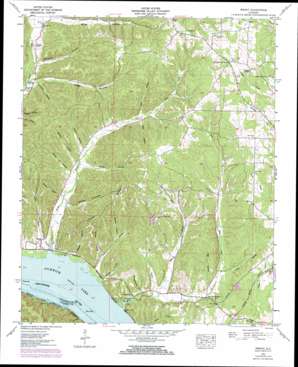
Wright Topo Map Alabama
To zoom in, hover over the map of Wright
USGS Topo Quad 34087h8 - 1:24,000 scale
| Topo Map Name: | Wright |
| USGS Topo Quad ID: | 34087h8 |
| Print Size: | ca. 21 1/4" wide x 27" high |
| Southeast Coordinates: | 34.875° N latitude / 87.875° W longitude |
| Map Center Coordinates: | 34.9375° N latitude / 87.9375° W longitude |
| U.S. State: | AL |
| Filename: | o34087h8.jpg |
| Download Map JPG Image: | Wright topo map 1:24,000 scale |
| Map Type: | Topographic |
| Topo Series: | 7.5´ |
| Map Scale: | 1:24,000 |
| Source of Map Images: | United States Geological Survey (USGS) |
| Alternate Map Versions: |
Wright AL 1935 Download PDF Buy paper map Wright AL 1953, updated 1958 Download PDF Buy paper map Wright AL 1953, updated 1973 Download PDF Buy paper map Wright AL 1953, updated 1973 Download PDF Buy paper map Wright AL 2011 Download PDF Buy paper map Wright AL 2014 Download PDF Buy paper map |
1:24,000 Topo Quads surrounding Wright
> Back to 34087e1 at 1:100,000 scale
> Back to 34086a1 at 1:250,000 scale
> Back to U.S. Topo Maps home
Wright topo map: Gazetteer
Wright: Islands
Brush Creek Island (historical) elevation 126m 413′Crusoe Island (historical) elevation 268m 879′
Wright: Parks
Brush Creek Park elevation 128m 419′Wright: Populated Places
Dart elevation 267m 875′Gravelly Springs elevation 141m 462′
Kendell (historical) elevation 247m 810′
Murphy Cross Roads elevation 257m 843′
Wright elevation 137m 449′
Wright: Post Offices
Dart Post Office elevation 267m 875′Wright: Ridges
Rainbow Ridge elevation 252m 826′Texas Ridge elevation 239m 784′
Wright: Springs
Gravelly Springs elevation 153m 501′Wright: Streams
Barton Branch elevation 127m 416′Bitter Branch elevation 130m 426′
Bluff Creek elevation 126m 413′
Brush Creek elevation 126m 413′
Dry Branch elevation 129m 423′
Fowler Branch elevation 160m 524′
Lindsey Branch elevation 185m 606′
Long Branch elevation 126m 413′
Pigeon Branch elevation 182m 597′
Shady Branch elevation 130m 426′
Troublesome Hollow Branch elevation 143m 469′
Wright: Summits
Bluff Creek Hill elevation 185m 606′Pettipoole Hill elevation 233m 764′
Wright: Valleys
Baskens Hollow elevation 156m 511′Beckham Hollow elevation 150m 492′
Bolling Spring Hollow elevation 132m 433′
Dump Hollow elevation 126m 413′
Gooch Hollow elevation 156m 511′
Landrum Hollow elevation 156m 511′
Landrum Hollow elevation 141m 462′
Lester Hollow elevation 147m 482′
Lewis Hollow elevation 154m 505′
Melton Hollow elevation 131m 429′
Menton Hollow elevation 155m 508′
Pitts Hollow elevation 188m 616′
Sharps Hollow elevation 146m 479′
Sigh Hollow elevation 148m 485′
Smith Hollow elevation 157m 515′
Smith Hollow elevation 141m 462′
Spain Hollow elevation 161m 528′
White Hollow elevation 157m 515′
Wright digital topo map on disk
Buy this Wright topo map showing relief, roads, GPS coordinates and other geographical features, as a high-resolution digital map file on DVD:


